Where to stay in Karvia
The right area depends on your trip. Here's who each one suits — pick the place, then the hotel.
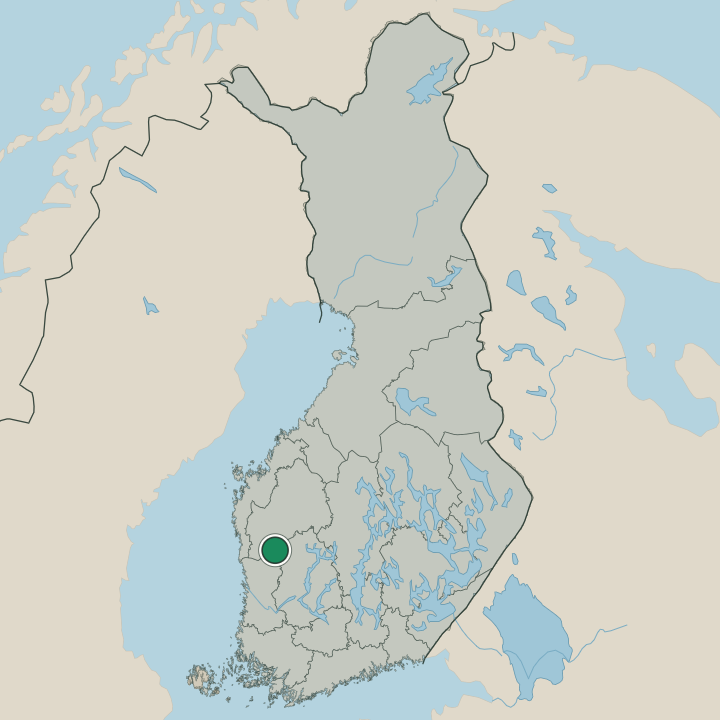
Karvia keeps only a modest stock of beds for a forest municipality of Satakunta, the kind of place where a small guesthouse or a cottage in the woods is the usual room. The village centre around the wooden Karvian kirkko suits visitors who want the parish on foot, with the church, the local shops and the Karvian kotiseutumuseo all within an easy walk in this corner of south-western Finland. It is the simplest base.
Out toward the Kauhanevan-Pohjankankaan kansallispuisto, cabins and cottages stand among the pinewoods and the mire edges, a good base for walkers heading onto the duckboard trails of the national park. Stock is thin away from the centre. Travellers tracing the old fortifications often stay near the redoubt of the Kyrön skanssi and the village of Karviankylä, while many instead sleep in the larger towns of Satakunta and drive in for a day on the bogs.
Book ahead in the bog-walking season, when the few rooms near the national park at Karvia go early.
About Karvia
What is Karvia known for?
Karvia is known above all for the Kauhanevan-Pohjankankaan kansallispuisto, the national park of open mire and pinewood that spreads across this corner of south-western Finland. Bogs define the place. The duckboard trails cross some of the widest raised bogs in Satakunta, while the wooden Karvian kirkko and the old redoubt of the Kyrön skanssi keep the history of the parish.
The Karvian kotiseutumuseo gathers the local past of farm, forest and the long sand ridges that run through the municipality.
What are the main landmarks in Karvia?
The Kauhanevan-Pohjankankaan kansallispuisto is the landmark that draws visitors to Karvia, a national park of raised bog and pinewood spread across this part of south-western Finland. In the village stands the wooden Karvian kirkko, the parish church, its belfry the Karvian kirkon tapuli rising beside it. History runs deep here.
The earthwork redoubt of the Kyrön skanssi recalls old border defence, the Pantin kivikautinen asuinpaikka marks a Stone Age dwelling site, and the historic sand-ridge road of the Hämeenkankaan- ja Kyrönkankaantie threads the forests of Satakunta past the Karvian kotiseutumuseo.
What is the history of Karvia?
Karvia's history runs from the forests and ridges of the backwoods to a settled parish. People worked this ground far back, as the Stone Age dwelling site of the Pantin kivikautinen asuinpaikka shows, and the long sand-ridge route of the Hämeenkankaan- ja Kyrönkankaantie carried travel and trade across the wild interior of south-western Finland long before the parish took shape. The land came slowly under the plough.
Scattered farms and forest hamlets of Satakunta, with old villages like Karviankylä, made up the settlement, and the earthwork redoubt of the Kyrön skanssi recalls the old defence of this border country. The parish gathered around its church. Karvia was chartered as a municipality in 1865, its centre set at the wooden Karvian kirkko whose belfry the Karvian kirkon tapuli stands beside, and the forest economy of timber and tar worked the pinewoods and the mires through the years that followed.
The wide raised bogs that now lie protected in the Kauhanevan-Pohjankankaan kansallispuisto were long a part of that working land, cut for peat and crossed by foot. Karvia settled into its quiet life as a forest municipality of Satakunta, its local past kept in the Karvian kotiseutumuseo.
Where is Karvia?
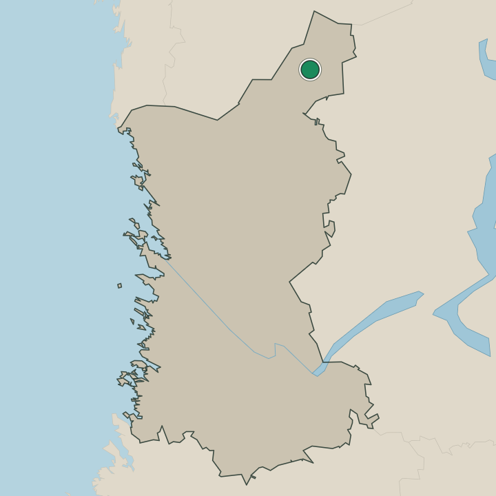
Karvia spreads across the forest-and-mire interior of northern Satakunta, in south-western Finland, a broad municipality of pinewood, bog and long sand ridges. The wide raised bogs of the Kauhanevan-Pohjankankaan kansallispuisto fill its western ground, the open mire crossed by duckboard among the pines. Land lies flat and high.
Threading the woods, the historic sand-ridge route of the Hämeenkankaan- ja Kyrönkankaantie runs past the village centre that gathers by the Karvian kirkko, with scattered hamlets like Karviankylä among the forests of this part of inland Satakunta.
What is the climate of Karvia?
Karvia has a cold continental climate, its seasons set hard by the forests and mires of the Satakunta interior. Winters are long and snowy, deep frost gripping the bogs of the Kauhanevan-Pohjankankaan kansallispuisto and the pinewoods around the village from early in the season until the late spring thaw. Summers are warm and bright.
The long northern daylight dries the duckboard trails and warms the sand ridges through the short growing season around Karvia, the season when walkers come onto the mires of this part of south-western Finland.
How do you get to Karvia?
Karvia lies in the forest interior of Satakunta, and the car is the usual way in along the roads that thread the pinewoods. No railway serves the village, so most travellers drive in from the larger towns of the region or follow the old sand-ridge line of the Hämeenkankaan- ja Kyrönkankaantie. The woods stretch on every side.
Bus links run to Karvia along the main roads, joining the small municipality to the rest of south-western Finland, and walkers bound for the national park come through the bigger towns before the last stretch into the mire country.
Where Karvia sits
Boundaries © geoBoundaries (CC BY) & Wikidata (CC0); water & neighbours: Natural Earth.