Where to stay in Kökar
The right area depends on your trip. Here's who each one suits — pick the place, then the hotel.
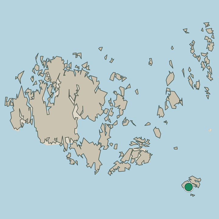
Kökar keeps a thin stock of beds for an outer municipality of the Åland Islands, where a guesthouse, a fishing cabin, or a room at the harbour is the usual lodging rather than a hotel. The settlement at Karlby holds the heart of the island, with the shop, the small services, and the ferry quay within reach of the road that threads the skerries. It is the natural base.
Rooms are few even there. Out by the islet of Hamnö, where the stone Kökars kyrka and the ruined Kökars konvent stand above the water, summer cottages and a handful of cabins look out over the Baltic Sea, a fine base for sea kayaking, fishing, and slow days on the rock. Stock thins toward the open skerries.
Travellers drawn to the bare Bronze Age shore of Otterböte should look toward the cabins of the eastern islets, while many visitors instead come for a single night off the long archipelago ferry. Book ahead in high summer, when the few rooms on this corner of the Åland Islands fill early.
About Kökar
What is Kökar known for?
Kökar is the lonely outpost of the Åland Islands, a low cluster of rock and water set far out in the Baltic Sea at the southern edge of the autonomous archipelago. The stone Kökars kyrka stands on the islet of Hamnö, where the ruined Kökars konvent recalls the Franciscan friars who once kept this seaward parish. People come for the bare rock.
The Bronze Age dwellings of Otterböte, the open skerries, and the long sea crossing draw travellers who want the far edge of Åland and little else.
What are the main landmarks in Kökar?
The stone Kökars kyrka is the chief landmark of the island, the parish church raised on the islet of Hamnö above the water of the Baltic Sea. Old faith and older life ring it. Beside the church stand the ruins of the Kökars konvent, the medieval Franciscan friary that once held this outer parish of the Åland Islands, while the bell tower of Kökars kyrka rises apart on the rock.
Far older still is Otterböte, the Bronze Age dwelling site whose hut floors mark some of the earliest settlement on Kökar, a record of people on these skerries long before the friars came.
What is the history of Kökar?
People reached Kökar in the Bronze Age. The hut floors of Otterböte mark a seasonal settlement of seal hunters on these outer skerries of the Baltic Sea, some of the oldest traces of life anywhere in the Åland Islands, left by people who crossed open water to a bare rock far from any mainland. For long centuries the island lived by the sea, by seal hunting and fishing and the lean keeping of a few beasts on thin soil, a scattered community on the southern rim of the archipelago.
The friars changed the island. In the Middle Ages a Franciscan house, the Kökars konvent, was raised on the islet of Hamnö, and around it the stone Kökars kyrka rose as the fixed centre of this seaward parish, its bell tower standing apart on the rock. The friary fell to ruin after the Reformation, yet the church held, and Kökar stayed what it had long been, a remote fishing and seafaring parish of the Åland Islands.
The old skerry life is read now in the Bronze Age floors of Otterböte and the medieval stones of Hamnö, two ages of settlement on one small island out in the Baltic Sea.
Where is Kökar?
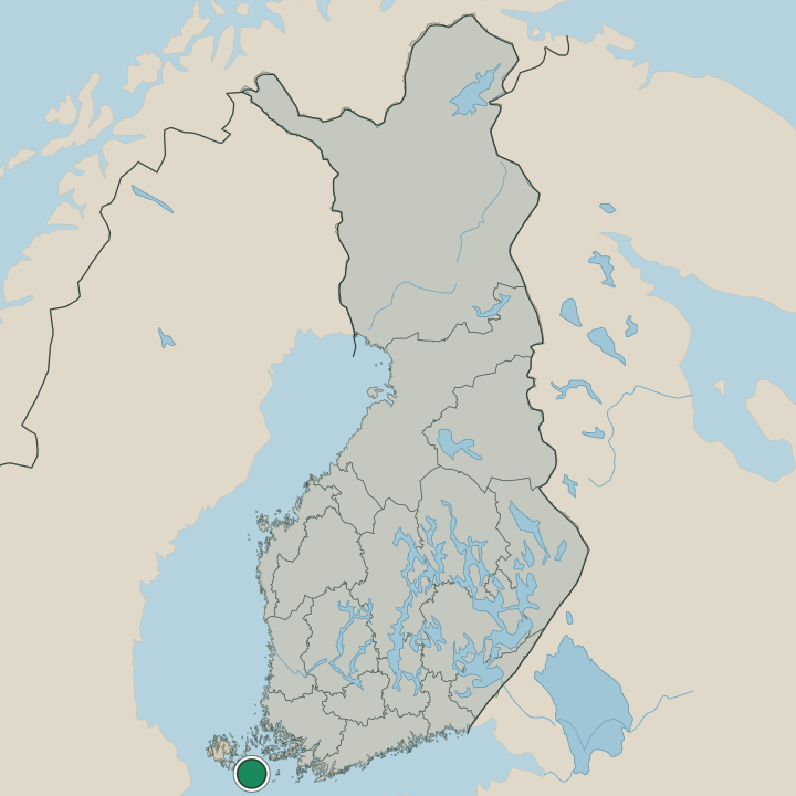
Kökar is a low scatter of rock and skerry lying far out in the Baltic Sea, at the southern edge of the Åland Islands and apart from the rest of the archipelago across open water. The sea rules every part of it. Bare granite, thin heath, and a few sheltered inlets make up the land, the islet of Hamnö holds the church and the friary ruin, and the harbour village of Karlby sits among the inner skerries where the road runs.
Open sea lies all around. Wind-scoured rock, narrow sounds, and the broad reach of the Baltic Sea give Kökar the spare, treeless form of an outer island, set far from any mainland shore.
What is the climate of Kökar?
Kökar has a cool maritime climate, ruled by the open water of the Baltic Sea that rings this outer island of the Åland Islands on every side. The sea softens the year. Winters stay milder than the Finnish mainland, though ice can close the sounds and wind drives hard over the bare rock past the stone Kökars kyrka, and the dark holds long over the skerries.
Then the bright summer comes. The long northern daylight warms the granite and the shallows, drawing kayakers, fishers, and the few summer visitors out to this far corner of the archipelago.
How do you get to Kökar?
Kökar lies far out in the Baltic Sea, and the archipelago ferry is the only way across. The long southern ferry route of the Åland Islands threads the skerries to the quay at Karlby, carrying cars, cyclists, and walkers on a crossing that can run for hours between the islands. The sea sets the pace.
From the landing the island road runs on through the bare rock to the islet of Hamnö, where the stone Kökars kyrka and the ruined Kökars konvent stand above the water at the heart of this outer parish.
Where Kökar sits
Boundaries © geoBoundaries (CC BY) & Wikidata (CC0); water & neighbours: Natural Earth.