Where to stay in Lemland
The right area depends on your trip. Here's who each one suits — pick the place, then the hotel.
Lemland keeps a modest stock of beds for a coastal municipality of the Åland Islands, where a guesthouse, a farm room, or a shoreline cabin is the usual lodging rather than a large hotel. The main island around the S:ta Birgitta kyrka holds the heart of the parish, with the small services and the old sea-captain's house at Pellas within reach of the road that runs south-east from the Lemström Canal. It is the natural base.
Beds are limited there. Out along the bridged isles of the Nåtö-Järsö chain, set just south of Mariehamn, summer cottages and cabins look over the Baltic Sea, a fine base for cycling, sailing, and slow days by the shore. Stock thins toward the outer skerries.
Travellers who want the Åland capital close at hand can stay on the Järsö isles and cross the water quickly, while those after the rural island settle near the church and the fields of Lemland. Book ahead in high summer, when the rooms on this corner of the Åland Islands fill early.
About Lemland
What is Lemland known for?
Lemland is the seafaring south-east corner of the Åland Islands, a largely rural municipality of the autonomous archipelago that lies just across the water from Mariehamn. The medieval S:ta Birgitta kyrka stands over the parish, and the maritime past runs deep here, from the sea-captain's house at Pellas to the memorial stone for the shipping master Algot Johansson. Sea shaped the place.
Travellers come for the Lemström Canal, the bridged isles of the Nåtö-Järsö chain, and the open Baltic Sea, drawn to a quiet coast within easy reach of the Åland capital.
What are the main landmarks in Lemland?
The medieval S:ta Birgitta kyrka is the chief landmark of the parish, the stone church standing over the rural island of Lemland in the Åland Islands. Sea marks the rest. Old shipping heritage fills the place: the sea-captain's house at Pellas, the memorial stone for the shipping master Algot Johansson recalling the men who sailed from these shores, and the villa and art of Andersudde with the homestead of Tomtebo scattered across the island.
The Lemström Canal, cut through the land in 1882, separates the main Åland island from the Lemland peninsula and stands as a work of the seafaring age.
What is the history of Lemland?
Lemland has long lived by the sea. Lying in the south-east of mainland Åland and close to the open shipping lanes of the Baltic Sea, the parish was an important maritime hub through the age of sail, its people sailing the world from a scatter of farms and harbours on the autonomous archipelago. The medieval S:ta Birgitta kyrka gathered that community, raised in stone over the fields and shores as the fixed centre of island life, while the captains and crews took their living from the deep water beyond.
Sail left its marks here. The sea-captain's house at Pellas keeps the shipping heritage of Lemland, and the memorial stone for the shipping master Algot Johansson recalls the men who carried the Åland flag across the oceans. In 1882 the Lemström Canal was carved through the land, cutting the main Åland island from the Lemland peninsula and easing the passage of boats between the sounds.
The bridged isles of the Nåtö-Järsö chain were later joined by causeways toward Mariehamn, drawing the southern part of the municipality close to the Åland capital, while the church and the old farms held the rural heart of Lemland on the Baltic Sea.
Where is Lemland?
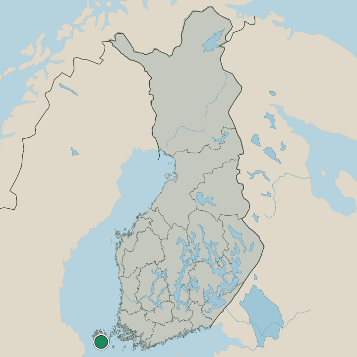
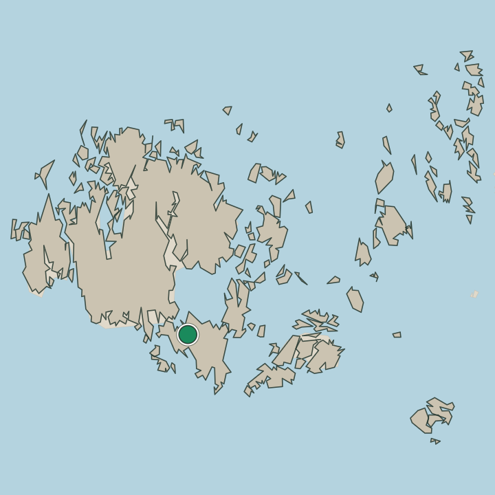
Lemland falls into two parts on the south-east edge of mainland Åland, set in the Baltic Sea within the Åland Islands. Water splits the land. The main part is the large island of Lemland, cut from the main Åland mass by the Lemström Canal and carrying the S:ta Birgitta kyrka and the old farms, while the second part is the bridged chain of small isles known as Nåtö-Järsö, linked by causeways south of Mariehamn.
Sea runs through it all. Sheltered sounds, low farmland, and rocky shores make up the municipality, its two parts strung along the southern coast of Åland on the Baltic Sea.
What is the climate of Lemland?
Lemland has a cool maritime climate, evened out by the surrounding Baltic Sea that rings this southern coast of the Åland Islands. The water tempers the year. Winters stay milder than the Finnish mainland, though ice can close the sounds around the Nåtö-Järsö isles and wind drives over the fields past the S:ta Birgitta kyrka, and the dark of the north holds long.
Then the bright summer comes. The long northern daylight warms the shores and the sheltered sounds of Lemland, drawing sailors, cyclists, and summer visitors out to this quiet corner of Åland near Mariehamn.
How do you get to Lemland?
Lemland sits just across the water from Mariehamn, and the road is the way in. From the Åland capital the route crosses the Lemström Canal onto the main island of Lemland, running south-east past the S:ta Birgitta kyrka and the old farms to the shores of the Baltic Sea. The bridges carry the rest.
A chain of causeways links the small isles of Nåtö-Järsö directly to the mainland south of Mariehamn, so much of this corner of the Åland Islands can be reached without a ferry, by car or by bicycle along the coast.
Where Lemland sits
Boundaries © geoBoundaries (CC BY) & Wikidata (CC0); water & neighbours: Natural Earth.