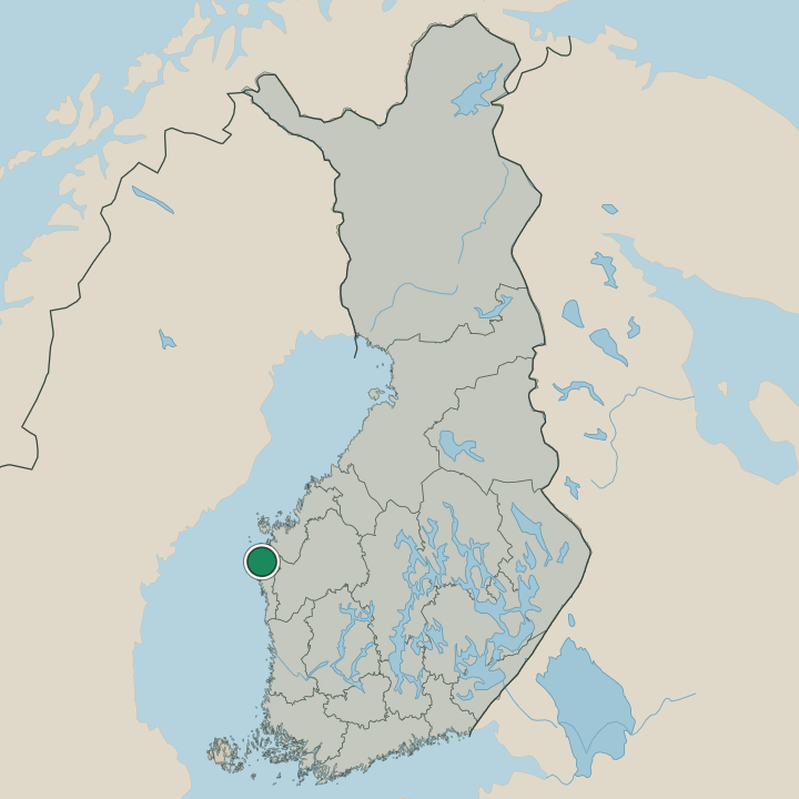
Where to stay in Korsnäs
The right area depends on your trip. Here's who each one suits — pick the place, then the hotel.
Korsnäs keeps a modest stock of beds, a coastal municipality of Pohjanmaa where a guesthouse, a farm room or a rented cottage by the shore is the usual room rather than a hotel. The church village around the Korsnäsin kirkko holds the centre, and a room here puts the parish church, the village shops and the road along the Gulf of Bothnia within easy reach. It is the simplest base.
Out along the coast, cottages and cabins stand near the fishing harbour of Harrströmin kalasatama ja kylä and the village of Moikipää, a fine base for the Merenkurkku, Höga kusten archipelago by boat or by car. Stock thins along the shore. Visitors drawn by the windmills of Tuulimyllyt, Harrström or the lighthouse islands of the Merenkurkun saariston majakka- ja luotsisaaret often stay in the small coastal villages, while many travellers instead sleep in the larger towns of Ostrobothnia and drive out to Korsnäs for the day.
Book ahead in summer, when the cottages along the Gulf of Bothnia fill early.
About Korsnäs
What is Korsnäs known for?
Korsnäs is known as a fishing and farming coast of Pohjanmaa, strung along the Gulf of Bothnia in western Finland. Its waters belong to the Merenkurkku, Höga kusten World Heritage Site, the Kvarken archipelago that rises slowly from the sea. The sea sets the rhythm.
The harbour village of Harrströmin kalasatama ja kylä, the windmills of Tuulimyllyt, Harrström and the wooden Korsnäsin kirkko all mark this Swedish-speaking stretch of the Ostrobothnian coast.
What are the main landmarks in Korsnäs?
The Korsnäsin kirkko is the landmark of the church village, the wooden parish church at the heart of Korsnäs in Pohjanmaa, its belfry the Korsnäsin kirkon tapuli standing beside it. Beyond it lies the coast. The fishing harbour of Harrströmin kalasatama ja kylä, the windmills of Tuulimyllyt, Harrström and the lighthouse islands of the Merenkurkun saariston majakka- ja luotsisaaret all line the Gulf of Bothnia, part of the Merenkurkku, Höga kusten World Heritage Site of this Ostrobothnian shore.
What is the history of Korsnäs?
Korsnäs grew from the sea. The Swedish-speaking villages of this Ostrobothnian coast lived by fishing the Gulf of Bothnia and farming the thin land behind the shore, gathered around the Korsnäsin kirkko whose belfry, the Korsnäsin kirkon tapuli, rose to mark the parish. Fishing fed the coast.
Harbours like Harrströmin kalasatama ja kylä and villages such as Moikipää worked the water, while the windmills of Tuulimyllyt, Harrström ground the grain of the farms along the western Finnish coast. The parish was set on its own footing when Korsnäs was chartered in 1887, a coastal municipality of Pohjanmaa spread across shore, archipelago and farmland. Land rose under it.
The slow uplift of the Merenkurkku, Höga kusten World Heritage Site lifted new ground from the Gulf of Bothnia, shifting harbours and shaping the lighthouse and pilot stations now kept as the Merenkurkun saariston majakka- ja luotsisaaret. Korsnäs settled into its role as a fishing and farming coast of Ostrobothnia, holding its Swedish speech and its sea-bound life along this stretch of western Finland.
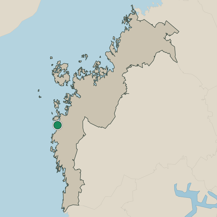
Where is Korsnäs?
Korsnäs lies along the Gulf of Bothnia in western Finland, a low coast of Pohjanmaa where land and sea meet in the Merenkurkku, Höga kusten archipelago. Shore, skerries and farmland make up the broad municipality, the church village gathered by the Korsnäsin kirkko above the water. The land is rising still.
Fishing villages like Moikipää and Harrströmin kalasatama ja kylä sit on the shifting shore, the lighthouse islands of the Merenkurkun saariston majakka- ja luotsisaaret out among the skerries of this Ostrobothnian coast.
What is the climate of Korsnäs?
Korsnäs has the cool maritime climate of the Gulf of Bothnia coast, its weather tempered by the sea yet cold once winter ice spreads across the western Finnish shore. The water moderates the air. Summers run mild and bright over the farms and skerries around the Korsnäsin kirkko, the long northern light drawing out the short coastal season, before the dark closes in and ice grips the Merenkurkku, Höga kusten archipelago off this Ostrobothnian coast.
How do you get to Korsnäs?
Korsnäs is reached by road along the coast of Pohjanmaa, a municipality with no station of its own. Most arrive by car. The coastal roads run down the Gulf of Bothnia from the larger towns of Ostrobothnia, threading the fishing villages and farmland to the church centre by the Korsnäsin kirkko.
Buses link it to the wider region, and from there the western Finnish road network reaches inland and on to the harbours of the Merenkurkku, Höga kusten coast.
Where Korsnäs sits
Boundaries © geoBoundaries (CC BY) & Wikidata (CC0); water & neighbours: Natural Earth.