Where to stay in Imatra
The right area depends on your trip. Here's who each one suits — pick the place, then the hotel.
Imatra spreads its beds along the harnessed rapids of South Karelia Region, an industrial town in south-eastern Finland where hotels gather near the old falls rather than in one tight core. The district around the Imatrankosken kirkko suits first visitors, close to the modernist church, the falls memorial of the Imatrankosken vesivoima-muistomerkki, and the riverside walks. It is the natural base.
Downstream toward the Tainionkosken kirkko, the steelworks quarter of Tainionkoski offers a quieter, more workaday foothold among the mills and the river, handy for travellers touring the industrial heritage of the town. Beds split between the two ends. Visitors drawn to the town's culture often stay near the Imatran taidemuseo and the Imatran kaupunginmuseo, while those tracing the war years look to the Lotta- ja veteraanimuseo, and many cross-border travellers use Imatra as a stop in south-eastern Finland.
Book ahead in summer, when the riverside hotels of South Karelia Region fill and rooms by the rapids go early.
Things to do in Imatra
Ranked by global recognition; descriptions from Wikidata (CC0).
Museums & Galleries
4- Lotta- ja veteraanimuseo
- Imatran taidemuseo
- Teollisuustyöväen asuntomuseo
- Imatran kaupunginmuseo
Churches & Religious Sites
3- Tainionkosken kirkko
- Imatrankosken kirkko
- Pyhän Nikolaoksen kirkko
worth knowingacross 2 categories in Imatra
About Imatra
What is Imatra known for?
Imatra is known as an industrial town of South Karelia Region, its name long tied to the power and steel of its harnessed rapids in south-eastern Finland. The Imatrankosken vesivoima-muistomerkki recalls the hydropower that built the place. Industry shaped the town.
The modernist Imatrankosken kirkko rises over the old falls district, the Imatran kaupunginmuseo keeps the city's record, and the Lotta- ja veteraanimuseo holds the memory of war in this corner of the Karelian borderland.
What are the main landmarks in Imatra?
The Imatrankosken vesivoima-muistomerkki is the landmark that tells Imatra's story, the hydropower memorial by the harnessed rapids that powered this South Karelia Region town. Above the falls rises the modernist Imatrankosken kirkko. The river holds more.
The brick Tainionkosken kirkko stands by the mills downstream, the Pyhän Nikolaoksen kirkko keeps the town's Orthodox tradition, and the Rautarouva-linjan muistomerkki preserves an old power pylon from the works that built south-eastern Finland's steel and electricity.
What is the history of Imatra?
Imatra's history runs on water and steel. The great rapids of the Vuoksi drew travellers and then engineers, and in the early twentieth century the falls were harnessed for hydropower, an act remembered in the Imatrankosken vesivoima-muistomerkki and the old line pylon kept as the Rautarouva-linjan muistomerkki. Power drew industry.
Steelworks and mills rose along the river at Tainionkoski, and a string of factory villages grew where the church of Tainionkosken kirkko now stands, drawing workers from across the Karelian country. The modern city came together late. The scattered industrial settlements of the rapids were joined and Imatra was chartered in 1948, gathering the works, the falls district around the Imatrankosken kirkko, and the river villages into a single town of south-eastern Finland.
War marked it deeply. Pressed hard against the eastern border, the town carried the weight of the Karelian wars, a memory now held in the Lotta- ja veteraanimuseo, while its industrial and civic past is gathered in the Imatran kaupunginmuseo by the river of South Karelia Region.
Where is Imatra?
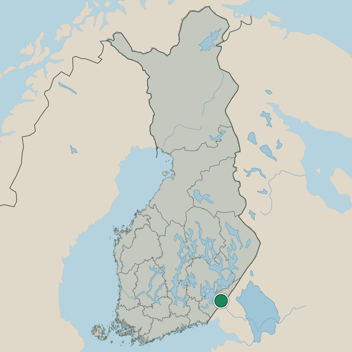
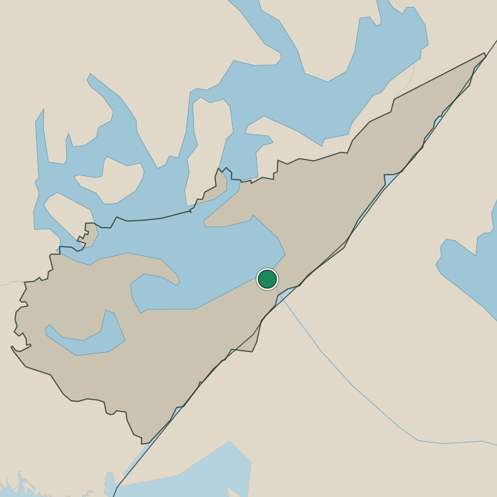
Imatra lies in south-eastern Finland, in the lake-and-river country of South Karelia Region close against the eastern border. The harnessed rapids run through the heart of the town, splitting it into riverside districts rather than gathering it into one core. Water orders everything here.
The falls quarter around the Imatrankosken kirkko sits upstream, the steelworks district of Tainionkoski lies below by the Tainionkosken kirkko, and forest and lake spread out around the industrial strip along the river of this Karelian borderland.
What is the climate of Imatra?
Imatra has a cold inland climate, its seasons set by the lakes and forests of South Karelia Region in south-eastern Finland. Winters are long and snowy, hard frost gripping the river and the woods around the town from early in the season until the late spring thaw. Summers are warm and bright.
The long northern daylight warms the rapids and the riverside districts of Imatra through the short growing season, the months when the falls run high before the snow returns to the Karelian borderland.
How do you get to Imatra?
Imatra sits on the railway and main road through South Karelia Region, and the train is a steady way in. Services reach the town from the regional cities, threading the lake country of south-eastern Finland to the river and its industrial districts. Road and bus also serve it well.
Coaches link Imatra to the larger towns of the region and the eastern border, carrying visitors to the falls quarter by the Imatrankosken kirkko and the works along the river.
Where Imatra sits
Boundaries © geoBoundaries (CC BY) & Wikidata (CC0); water & neighbours: Natural Earth.