Where to stay in Luumäki
The right area depends on your trip. Here's who each one suits — pick the place, then the hotel.
Luumäki keeps a modest stock of beds for a municipality of South Karelia, the kind of place where a small hotel or a roadside inn near Taavetti is the usual room. The village of Taavetti around the Taavetin linnoitus suits visitors who come for the history, with the old fortress, the shops and the main road through south-eastern Finland all close at hand. It is the simplest base.
Out across the woods and lakes, cottages stand among the trees near the Salpalinja bunker line and the cliffs that carry rock paintings, a good base for those touring the defences and the ancient art. Stock is thin once you leave the village. Some visitors instead sleep in the larger towns of South Karelia and drive in for the day, while travellers keen on the local past often base themselves near the church of Luumäen kirkko or the museum farm of Kotkaniemi in this south-eastern Finnish municipality.
Book ahead in summer, when the history crowds fill Luumäki and the few rooms by Taavetti go early.
About Luumäki
What is Luumäki known for?
Luumäki is known for its place on the eastern defences of Finland, where the Salpalinja bunker line runs through this corner of South Karelia. War and stone mark the land. The Taavetin linnoitus, a fortress raised at the village of Taavetti, holds the older defensive ground, while the parish church of Luumäen kirkko and its belfry stand at the church centre.
The farm of Kotkaniemi keeps a museum, and ancient rock paintings such as the Valkjärven kalliomaalaus line the cliffs of this south-eastern Finnish municipality.
What are the main landmarks in Luumäki?
The Salpalinja bunker line is the landmark that tells Luumäki's story, the eastern defence of Finland that threads through this corner of South Karelia. The Taavetin linnoitus, an earthwork fortress at the village of Taavetti, holds the older line of defence with its ramparts and gates. War and rock here.
The parish church of Luumäen kirkko stands with its belfry the Luumäen kirkon tapuli at the church centre, the museum farm of Kotkaniemi keeps the local past, and ancient rock paintings such as the Inkilän kalliomaalaus line the cliffs of this south-eastern Finnish municipality.
What is the history of Luumäki?
Luumäki's history is written in defence and the border. Ancient hunters left rock paintings such as the Vaskivuoren kalliomaalaus and the Myllyojan kalliomaalaus on the cliffs above its lakes long before any parish gathered, and the church district was set on its own footing when it was chartered in 1642 around the church that became the Luumäen kirkko. The border ran close.
The Taavetin linnoitus rose as an earthwork fortress at Taavetti to hold the eastern frontier, a line of ramparts guarding the road through this corner of South Karelia. War shaped the centuries that followed. The Salpalinja, the great bunker line built to defend the eastern border of Finland, was dug through the woods and waters of the municipality, its concrete and stone still threading the land.
The farm of Kotkaniemi grew on the lakeside and is now kept as a museum, and the Oikeustaistelun muistomerkki marks a remembered struggle of the district. Luumäki settled into its role as a border municipality of South Karelia, its history bound to the fortress at Taavetti and the defensive lines of south-eastern Finland.
Where is Luumäki?
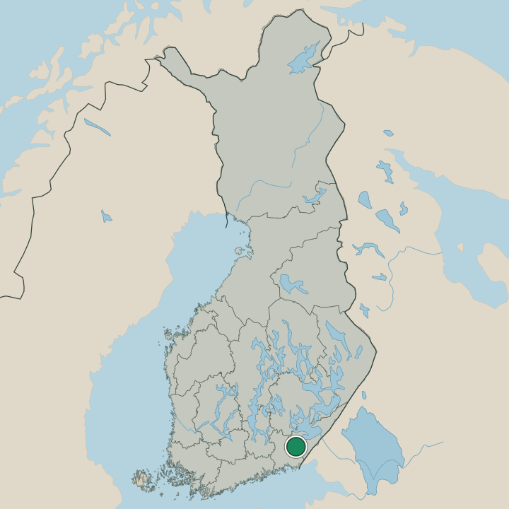
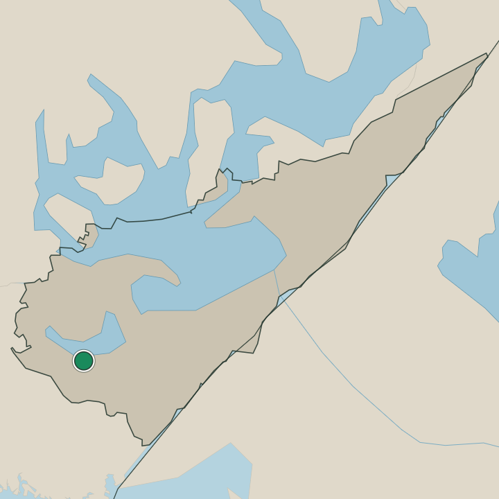
Luumäki lies in the lake-and-forest country of South Karelia, in south-eastern Finland. Lakes, ridges and pinewoods fill the broad municipality near the eastern border, the village of Taavetti gathered by its fortress while water and rock spread out beyond. Cliffs rise over the lakes.
The painted rock faces such as the Siliävuoren kalliomaalaus stand above the water, the Salpalinja bunker line threads the woods toward the frontier, and farm hamlets lie scattered among the forests of this south-eastern Finnish corner of South Karelia.
What is the climate of Luumäki?
Luumäki keeps the cold inland seasons of the South Karelian lake country. Winters are long. Hard frost grips the lakes and the pinewoods around Taavetti from early in the season until a late spring thaw, the snow lying deep over the bunker line and the painted cliffs for months.
Summers turn warm and bright, the long northern daylight warming the water and the forests around Luumäki through a short growing season before the cold returns to this south-eastern Finnish corner near the border.
How do you get to Luumäki?
Luumäki sits on the main road and railway through south-eastern Finland, and both run past the village of Taavetti. Easy to reach. Cars and buses come along the highway through South Karelia to the centre by the Taavetin linnoitus, the simplest route into the border country, and the train stops on the eastern line nearby.
Visitors drawn to the Salpalinja bunker line and the rock paintings aim for Taavetti before fanning out to the woods and cliffs of this south-eastern Finnish municipality.
Where Luumäki sits
Boundaries © geoBoundaries (CC BY) & Wikidata (CC0); water & neighbours: Natural Earth.