Where to stay in Taipalsaari
The right area depends on your trip. Here's who each one suits — pick the place, then the hotel.
Taipalsaari keeps a modest stock of beds. The municipality is rural and broken by water, so most of its rooms gather in the village near Taipalsaaren kirkko, where guesthouses and lodgings serve the travellers drawn to Lake Saimaa and the Saimaa Geopark in this corner of South Karelia in south-eastern Finland. Beds here are few.
Out along the shores and islands, holiday cabins open through the warm months for those drawn to the lake, the boating, and the wide water country of the parish. The wider municipality holds the rest. Cottages and summer rooms scatter across the islands and shores of Lake Saimaa near the old Kutveleen kanava, a fit for boaters, anglers, and anyone seeking the quiet of south-eastern Finland, while the city of Lappeenranta nearby offers the larger hotels and the range of a town within reach of Taipalsaari.
About Taipalsaari
Taipalsaari is known for its water and its old defences.
What is Taipalsaari known for?
Taipalsaari is known for its water and its old defences. The municipality spreads across the islands and shores of Lake Saimaa in this corner of South Karelia, part of the Saimaa Geopark, with the medieval Taipalsaaren kirkko standing by the lake. War and ancient peoples marked the land too.
The Salpalinja bunker line runs through the eastern country near here, prehistoric rock paintings face the water, and old hill forts crown the heights of south-eastern Finland.
What are the main landmarks in Taipalsaari?
Lake Saimaa is the feature that defines Taipalsaari. Its islands and shores form the Saimaa Geopark, and the medieval Taipalsaaren kirkko with its belfry stands by the water in this lakeside municipality of South Karelia. Deep history rings the lake.
Ancient hill forts such as Kuivaketveleen linnavuori and Kannuksen linnavuori crown the heights, prehistoric rock paintings face the water, the Salpalinja bunker line guards the eastern border, and old waterways like the Kutveleen kanava and the Suvorovin sotakanavat thread the country of south-eastern Finland.
What is the history of Taipalsaari?
People have lived by this lake since prehistory. Hunters and fishers left rock paintings on the cliffs above Lake Saimaa and raised hill forts such as Kuivaketveleen linnavuori and Kannuksen linnavuori across the heights of what is now South Karelia. A parish gathered the later settlers.
The municipality was chartered in 1571, and the medieval Taipalsaaren kirkko rose by the water as the church of the scattered lakeside community of south-eastern Finland. The eastern frontier shaped its later age. Russian forces under Suvorov cut the Suvorovin sotakanavat and the Kutveleen kanava to move boats through the waters of Saimaa, and centuries later the Salpalinja bunker line was dug along the eastern border to defend the country.
Water held the place together. The islands and shores of Lake Saimaa, now part of the Saimaa Geopark, carried boats and timber and fish for the people of the parish, and so an ancient lakeside settlement endured into the present municipality of South Karelia.
Where is Taipalsaari?
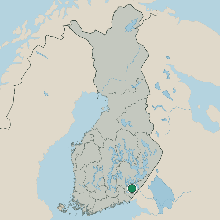
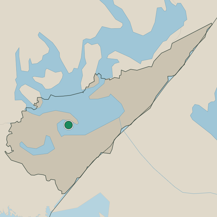
Taipalsaari lies in South Karelia, in south-eastern Finland, a municipality half made of water. The islands and shores of Lake Saimaa break its ground into ridges and bays, much of it within the Saimaa Geopark, with the village and Taipalsaaren kirkko set by the lake. Water rules this land.
Eskers and forested ridges run between the bays, the old Kutveleen kanava cuts across a neck of land, and the lake stretches away toward the city of Lappeenranta and the rest of south-eastern Finland.
What is the climate of Taipalsaari?
Taipalsaari has a cold inland winter. Ice locks the bays of Lake Saimaa for months, and snow lies across the ridges and forests of South Karelia through the dark season of south-eastern Finland. Summers are mild and bright.
The warm months bring boaters and swimmers to the shores around Taipalsaaren kirkko and the islands of the Saimaa Geopark before the cold returns. Spring and autumn pass quickly between.
How do you get to Taipalsaari?
Taipalsaari is reached by road from Lappeenranta. The city lies close by in South Karelia, and roads run out from it across the necks of land to the village and Taipalsaaren kirkko, the usual way into this lakeside municipality. Water offers another route.
Boats cross Lake Saimaa and pass the old Kutveleen kanava to reach the islands and shores of the parish, while the roads of south-eastern Finland tie this water country to the wider region.
Where Taipalsaari sits
Boundaries © geoBoundaries (CC BY) & Wikidata (CC0); water & neighbours: Natural Earth.