Where to stay in Ruokolahti
The right area depends on your trip. Here's who each one suits — pick the place, then the hotel.
Ruokolahti keeps a modest stock of beds for a lakeland municipality of South Karelia, the kind of place where a small hotel, a guesthouse or a lakeside cottage is the usual room. The church village around the wooden Ruokolahden kirkko and its tall belfry the Ruokolahden kellotapuli suits visitors who want the old centre and the local museum on foot, with the Ruokolahden kotiseutumuseo close at hand. It is the simplest base.
Out across the waters and forests of Saimaa, cabins and waterside cottages stand among the pines near the lake-and-rock country of the Saimaa Geopark and the hill of Haukkavuori, a fine base for touring the south-eastern Finnish lakeland by car and boat. Stock thins away from the centre. Visitors drawn to the borderland often stay near the wartime works of the Salpalinja or the old canals like the Kutveleen kanava, while many travellers instead sleep in the larger towns of South Karelia and drive in for the day.
Book ahead in summer, when the lakeside cottages around Ruokolahti fill and the few central rooms go early.
About Ruokolahti
What is Ruokolahti known for?
Ruokolahti is known as a lakeland municipality of South Karelia, set on the waters of Saimaa near the eastern border in south-eastern Finland. The wartime bunker line of the Salpalinja runs through its forests, the eastern defensive works that mark this borderland. Water and rock define the rest.
The lake-and-rock country of the Saimaa Geopark, the old waterway of the Kutveleen kanava and the prehistoric rock painting at Kolmiköytisienvuoren kalliomaalaus all draw visitors to this corner of the lakeland.
What are the main landmarks in Ruokolahti?
The wartime bunker line of the Salpalinja is the landmark that marks this borderland, the eastern defensive works threading the forests of Ruokolahti. Older works cross the water. The military canals of the Suvorovin sotakanavat and the Kutveleen kanava, along with the 1790 Kukonharjun kanava, cut through the lakes of Saimaa, while the wooden Ruokolahden kirkko and its belfry the Ruokolahden kellotapuli hold the old church village.
Prehistoric rock paintings at Kolmiköytisienvuoren kalliomaalaus and Lapinvuoren kalliomaalaus reach far back in this part of South Karelia.
What is the history of Ruokolahti?
Ruokolahti's history reaches back to the people who painted the rock. The prehistoric red ochre figures at Kolmiköytisienvuoren kalliomaalaus and Lapinvuoren kalliomaalaus show that hunters and fishers worked the shores of Saimaa long before any parish rose, their old camps now scattered across the island sites of this corner of South Karelia. Water carried the first life here.
The parish gathered slowly around the wooden Ruokolahden kirkko, chartered as its own community in 1868, the church and its belfry the Ruokolahden kellotapuli giving the lakeland farms a centre near the eastern border. The border itself shaped much of what followed. Long before the modern works, the military canals of the Suvorovin sotakanavat and the 1790 Kukonharjun kanava were cut to move troops and goods through the lakes of Saimaa, and the heritage roads of Niskapietiläntie and Sarajärven tie threaded the country.
The wartime bunker line of the Salpalinja later ran through the forests of Ruokolahti as the eastern defence, and the long memory of this borderland is gathered now in the Ruokolahden kotiseutumuseo and across the lake-and-rock landscape of the Saimaa Geopark.
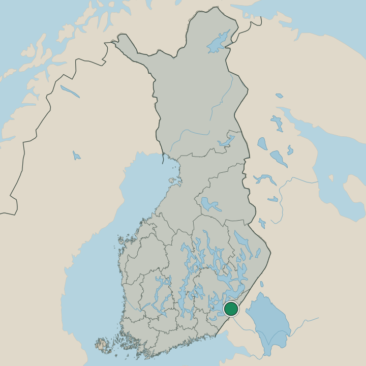
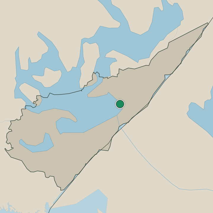
Where is Ruokolahti?
Ruokolahti lies on the waters of Saimaa in South Karelia, in south-eastern Finland, a country of long lakes, rock ridges and pine forest near the eastern border. Water and rock fill the broad municipality, the church village gathered by the shore while islands, sounds and bluffs reach out across the lake. The lake-and-rock land runs deep here.
The hill of Haukkavuori rises over the water within the Saimaa Geopark, the old canals like the Kutveleen kanava and the Käyhkään kanava cut between the lakes, and island sites like Kalmasaari and Meteliniemi lie scattered across this corner of South Karelia.
What is the climate of Ruokolahti?
Ruokolahti carries the cold, continental seasons of the South Karelian lakeland, its weather set hard by the deep waters of Saimaa and the surrounding pinewoods near the eastern border. Winters are long and snowy. Deep frost grips the lake and the forests around the church village from early in the season until the late spring thaw, the canals icing over and the bluffs of Haukkavuori white through the dark months.
The long northern daylight then warms the lake through a green and lengthening summer, the season when the cottages along the Saimaa shore fill before the snow returns again.
How do you get to Ruokolahti?
Ruokolahti sits on the road and rail routes of south-eastern Finland, and the car is the usual way in. Roads run through the lakeland of South Karelia to link the church village with the larger towns near the eastern border. Trains pass nearby too.
Rail services on the eastern line reach the regional towns, and visitors from farther off come through those centres before the last stretch out to Ruokolahti, the waters of Saimaa and the lake-and-rock country of the Saimaa Geopark.
Where Ruokolahti sits
Boundaries © geoBoundaries (CC BY) & Wikidata (CC0); water & neighbours: Natural Earth.