Bangladesh
Barisal Division, Bangladesh — Towns & Travel Guide


Barisal Division is Bangladesh's river country, a delta of rice, canals and floating guava markets south of Dhaka.
About Barisal Division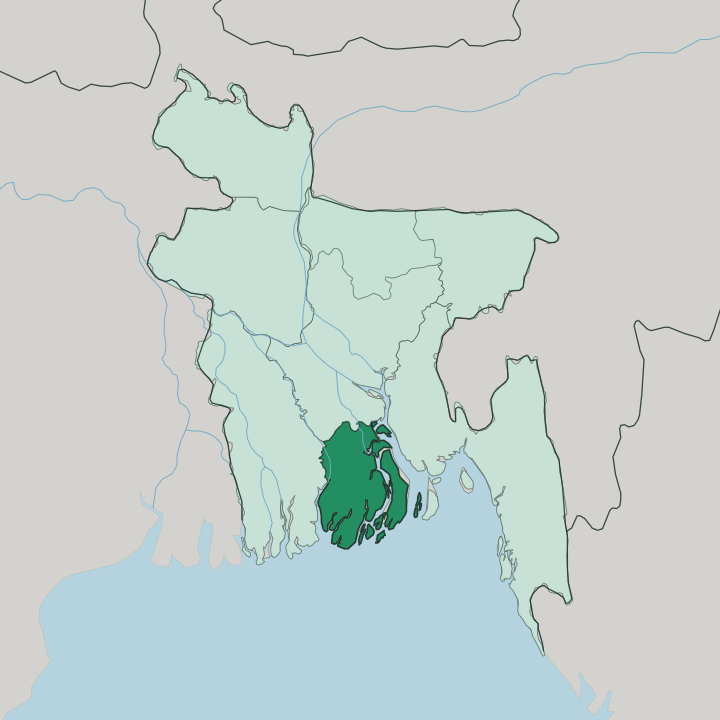
Towns & cities in Barisal Division
Pick a town or city — each links to where to stay.
Barisal city is the natural base, tied to Dhaka by the overnight launches and within reach of the guava markets. Kuakata is the other draw. It stands on the coast in Patuakhali, the rare beach where the sun both rises and sets over the Bay of Bengal, and it holds most of the division's seaside rooms.
The floating markets at Bhimruli and Kuriana are a day trip more than a stay, since beds thin out fast in the orchard villages. Choose Barisal city for the rivers and the launches; choose Kuakata when you want the sea.
About Barisal Division
Water defines this place.
What is Barisal Division known for?
Barisal Division sits in the Padma delta, laced with so many rivers and canals that boats do the work roads do elsewhere, and locals sum it up in a rhyme: Dhan-Nodi-Khal, Ei tin-e Borishal, rice, river and canal. The floating guava markets at Bhimruli and Kuriana draw the biggest crowds, boats piled with fruit trading on the water. Down at the coast, Kuakata beach faces the Bay of Bengal.
Barisal city, on the Kirtankhola River, is the hub for it all.
Where is Barisal Division?
Barisal Division fills the south-central delta of Bangladesh, on the seaward edge of the great Ganges plain. It is the least populous of the country's eight divisions, and among the wettest. Dhaka Division lies to the north, across the rivers that carry the launches down from the capital.
The Bay of Bengal closes the whole southern side, and beyond the last mudflats the sea takes over. Chittagong Division sits to the east and Khulna Division to the west, so on three sides the borders are water or the land that water keeps rearranging. The Padma, the main channel of the Ganges through Bangladesh, breaks into a fan of distributaries here before reaching the sea.
Barisal city stands inland on the Kirtankhola, an offshoot of the Arial Khan River, well back from the coast. Rivers do more than drain this land. The Bishkhali, the Baleshwar, the Tetulia and the Payra thread the division into a mesh of islands and chars, the low silt banks that the current builds one season and takes back the next.
The southwest edges into the Sundarbans, the tidal mangrove forest shared with Khulna and with India across the border. Kuakata, on the outer coast in Patuakhali, is where the land finally runs out at the Bay of Bengal. Almost nowhere here sits far from moving water.
What is Barisal Division like?
Life in Barisal runs to the rhythm of the water. Boats are the everyday transport, the market floor and the school run, and the calendar bends around the monsoon rather than the clock. The people are almost entirely Bengali, and the language of the streets, the courts and the songs is Bengali.
Rice and fish anchor the table, the paddy grown across the delta and the hilsa netted from its rivers and the Bay of Bengal beyond. Fruit belongs to the picture too. The orchards of Pirojpur and Jhalokati make this the guava country of Bangladesh, and coconut and betel-nut palms crowd the canal banks.
The floating guava markets are the region's signature: through the July and August harvest, growers paddle flat boats heaped with fruit into the narrow canals at Bhimruli and Kuriana, and the trading happens hull to hull on the water. It is a working market first and a spectacle second. Mosques and old Hindu temples stand side by side in the towns, a legacy of the delta's mixed past.
The launch itself is a kind of institution here, the overnight ferry from Dhaka a slow, social ritual that Barisalis speak of with real affection. Water is not the backdrop. It is the way the whole place works.
What is the history of Barisal Division?
Long before the division was drawn, this delta was the kingdom of Chandradwip, and the old town of Barisal grew up under the earlier name of Bakla. Its wealth came from water and trade. From the Middle Ages the delta worked as a trans-shipment point, moving rice and lentils and stacked hides out of Bengal along the same rivers that still carry the launches.
The modern division is young. Barisal became a separate division of Bangladesh in 1993, carved from the wider south to govern the six districts of the lower delta. Its rivers had been running the local economy for centuries before any line on a map made it official.
What is the climate of Barisal Division?
Barisal has a tropical monsoon climate, and the year splits cleanly in two. From roughly June the monsoon breaks over the delta and dumps most of the annual rain in a few heavy months, with July the wettest, filling the canals that the guava boats depend on. Winters are dry, mild and short.
Sitting on the Bay of Bengal, the division also lies in the path of the cyclones that spin up over the bay, and its low chars and coastal fringe take the brunt when a storm makes landfall. Heat and humidity hold through much of the year. It is a wet country by design.
How do you get to Barisal Division?
The classic way in is by water. Overnight launches run down the rivers from Dhaka to Barisal city, an eight-to-nine-hour glide through the delta that most travellers rate as the trip's high point rather than a chore. Buses cover the same ground faster now that bridges span the big channels.
Barisal has its own airport with flights to Dhaka for anyone short on time. Once you arrive, smaller boats take over for the guava markets and the canal villages, while the road south leads on to Kuakata and the Bay of Bengal.
Good for
Updated July 2026