Bangladesh
Khulna Division, Bangladesh — Towns & Travel Guide


Khulna Division fills the south-west corner of Bangladesh, where the Sundarbans mangroves meet the Bay of Bengal.
About Khulna Division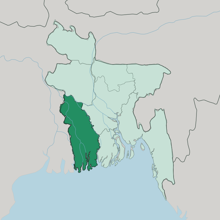
Towns & cities in Khulna Division
Pick a town or city — each links to where to stay.
Khulna city is the practical base, sitting where the Rupsha and Bhairab rivers meet, and it holds the division's most comfortable hotels and nearly every Sundarbans boat departure. Mongla lies closer to the forest. Its riverside lodges near the Chila gate cut the run to the mangrove channels to about an hour.
Bagerhat suits those who want the Mosque City at their doorstep, with the Sixty Dome Mosque a walk from the guesthouses. Fly into Jashore and you can spend a first night there before the road south. Choose Khulna for comfort and boats; choose Mongla to wake up beside the water.
About Khulna Division
The Sundarbans define it.
What is Khulna Division known for?
The world's largest mangrove forest spreads across the three southern districts of Khulna Division, and its tidal channels shelter the Royal Bengal tiger. Inland at Bagerhat stands the Mosque City, where Khan Jahan Ali raised the brick Sixty Dome Mosque in the fifteenth century, now protected as a UNESCO site. Khulna city anchors the north, its jute mills and shrimp-processing yards feeding the cargo ships that dock downriver at the Port of Mongla.
Where is Khulna Division?
Khulna Division occupies the delta country of south-western Bangladesh, a low plain of silt laid down by the great rivers of the Ganges system. Water shapes everything. To the west runs the border with the Indian state of West Bengal, and to the south the land dissolves into the Bay of Bengal through the tidal maze of the Sundarbans.
The Padma, the name the Ganges takes on its way through Bangladesh, marks much of the northern edge. Between these limits the division is threaded by a dense braid of rivers, the Rupsha, the Bhairab, the Gorai-Madhumati and the Pasur among them, all sliding southward toward the sea. Khulna city stands at the confluence of the Rupsha and the Bhairab in the north of the division, a river port set back from the coast.
Downstream, the Pasur carries ships to the Port of Mongla near the forest edge. The Sundarbans cover the three southernmost districts, a belt of salt-tolerant mangrove that absorbs the cyclones rolling in off the Bay of Bengal. Elevation here is measured in a handful of metres.
The delta is flat, wet and endlessly cut by channels, and at high tide the line between land and river blurs across much of the coastal south. It is a landscape built by water and still governed by it.
What is Khulna Division like?
Life in Khulna Division runs on the rivers and on Bangla, the language spoken across the whole delta. This is working country. The economy grew up around jute, the golden fibre once milled by the ton in Khulna city, and around shrimp, farmed in the brackish coastal ponds and shipped out through the Rupsha yards to markets abroad.
Fish is everywhere, from the ponds of Jashore district to the tidal catch of the Sundarbans, and rice fills the fields wherever the water runs sweet rather than salt. Jashore is known for its date-palm molasses, tapped in the cool months and boiled down into the dark gur that flavours winter sweets across Bangladesh. The craft towns keep the old handwork of weaving and metal alive.
Faith runs deep in the division, and the shrine of Khan Jahan Ali at Bagerhat still draws pilgrims to the tomb of the fifteenth-century Sufi who built its mosques. The Bangla New Year and the harvest bring music and fairs to riverbank towns. It is a culture shaped by tide and season, patient and turned toward the water.
What is the history of Khulna Division?
The oldest story is brick. In the fifteenth century the Sufi general Khan Jahan Ali cleared the mangrove and raised the walled settlement of Khalifatabad, its Sixty Dome Mosque still standing at Bagerhat under the Bengal Sultanate. Under British rule the delta belonged to the sprawling Presidency Division of Bengal, and Khulna grew into a river port trading jute down to Calcutta.
The Partition of 1947 cut those old ties across the new frontier with West Bengal. Khulna Division took its present form in 1960, carved out under East Pakistan, and its port and mills have anchored the south-west ever after.
What is the climate of Khulna Division?
Khulna Division has a tropical wet-and-dry climate ruled by the South Asian monsoon. The rains arrive with force. Most of the year's downpour falls between May and October, when warm, sodden air pushes up from the Bay of Bengal and the rivers swell across the delta.
The dry months from November to February are warmer and gentler, the usual window for a Sundarbans trip. Cyclones spun up over the Bay of Bengal are the real hazard, and the mangrove belt takes the first blow of any storm surge before it reaches the towns inland.
How do you get to Khulna Division?
Most travellers reach Khulna Division from Dhaka. The quickest air link is the short hop to Jashore Airport, the division's only working airfield, with several daily flights from the capital before the road on to Khulna city. Overland has grown far easier since the Padma Bridge opened the direct highway across the great river, cutting the Dhaka run to a matter of hours.
From Khulna, boats and buses fan out to the coast, carrying visitors down to Mongla and the launch points for the Sundarbans. Cargo, meanwhile, moves through the Port of Mongla on the Pasur.
Updated July 2026