Bangladesh
Rajshahi, Bangladesh — Towns & Travel Guide


Rajshahi is Bangladesh's silk and mango region, spread across the Barind terrace on the north bank of the Padma River.
About Rajshahi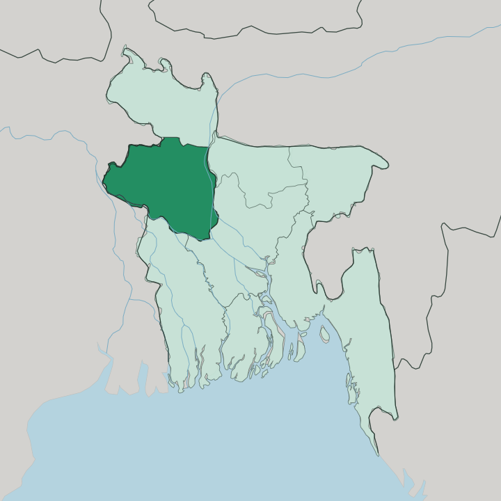
Towns & cities in Rajshahi
Pick a town or city — each links to where to stay.
Rajshahi city is the natural base. It is a silk-city capital strung along the Padma embankment, with the Varendra Research Museum, the riverfront promenade, and the old silk mills gathered within it. Bogura sits further north, the market town beside the ruins of Mahasthangarh.
Naogaon is the quiet town nearest Paharpur. Pabna anchors the south on the lower Padma, a handloom district near the Hardinge Bridge. Pick the city for silk.
Head instead to Bogura or Naogaon when the ancient sites are the whole reason for the trip.
About Rajshahi
Rajshahi is the silk and mango region of Bangladesh.
What is Rajshahi known for?
Its capital city carries the nickname the silk city. Orchards across the districts of Chapainawabganj and Naogaon ripen some of the country's best-loved mangoes and litchis, sold cheaply through the summer. The region also holds the deepest layers of Bengal's past, from the Buddhist monastery at Paharpur to the terracotta mosques and temples scattered through its towns.
Handloom silk, sweet fruit, and old brick together make the reputation.
Where is Rajshahi?
Rajshahi fills the north-west corner of Bangladesh, wedged against the Indian border. The Padma River defines it. That river is the main distributary of the Ganges, and it runs along the region's southern and western edge, dividing Rajshahi from West Bengal across the water. Rangpur Division lies to the north, and the divisions of Dhaka and Khulna reach in from the east and south.
Much of the land is the Barind Tract, a slightly raised terrace of old reddish clay that stands a little above the surrounding floodplain. Between that terrace and the river lie the newer alluvial flats, threaded by the Atrai, the Mahananda, and the Jamuna. Eight districts make up the region.
They run from Chapainawabganj on the border, through Rajshahi, Naogaon, Natore, Bogura, and Joypurhat, down to Sirajganj and Pabna in the south. The capital city stands on the north bank of the Padma, close enough to India that the far shore is another country. Flat and heavily farmed, the land is laced with rivers across the whole plain.
The Barind gives it the only relief it has.
What is Rajshahi like?
Silk is the thread that runs through Rajshahi's sense of itself. The capital city built its name on the handloom, and Rajshahi silk still sells cheaper here than anywhere else in the country. Mangoes matter just as much.
When the orchards of Chapainawabganj ripen in early summer, the whole region turns to the harvest, and the fruit markets fill with the varieties that made the area the mango capital. The people speak Bengali, the language of Bengal on both banks of the Padma. Faith and craft are stamped into the land.
The terracotta mosque at Bagha, raised under the Bengal Sultanate, and the cluster of Hindu temples at Puthia both show the fired-brick decoration that Bengal made its own. Rajshahi University keeps the intellectual life of the north running, and the Varendra Research Museum beside it holds sculpture and inscriptions dug from the surrounding plain. Old faiths, old crafts, old learning.
They still shape the days here. The region wears its heritage in brick and cloth, not in monuments alone.
What is the history of Rajshahi?
This was ancient Pundravardhana. Its capital, Pundranagara, stood at Mahasthangarh near Bogura, one of the earliest cities of the whole subcontinent, fortified from around the third century before the common era. Buddhism flowered here under the Pala kings, who raised the great monastery of Somapura Mahavihara at Paharpur in the eighth century.
Later rulers left their own marks: the Bengal Sultanate built the domed brick mosque at Bagha in 1523, and Hindu zamindars raised the temples of Puthia. Layer on layer of Bengal's past sits in this soil.
What is the climate of Rajshahi?
Rajshahi runs hot and dry by Bangladeshi standards. Sheltered inland from the sea, the Barind Tract heats up hard, and the hot season stretches from March into the middle of July. The heat bites.
Peak months push the mercury toward the high thirties, and a bad heatwave can crack litchis on the branch and drop mangoes before they ripen. The summer monsoon then breaks over the region, soaking the plain and feeding the Padma. Short, notably cool winters follow.
It is a region of extremes.
How do you get to Rajshahi?
Most travellers reach Rajshahi from Dhaka. Shah Makhdum Airport, on the edge of the capital city, takes short daily flights from the national airport at Dhaka. The train is the classic way in.
Intercity services such as the Silk City Express and the Bonolota Express run the roughly 245 km up from Dhaka, crossing the great rivers of the plain to reach the Padma. Buses cover the same ground by road. Once here, the districts spread out around Rajshahi city, and local road links tie Bogura, Naogaon, and Pabna into the whole.
Good for
Updated July 2026