Indonesia
Southwest Papua, Indonesia — Towns & Travel Guide


Southwest Papua caps the far northwest of New Guinea, the Bird's Head Peninsula province whose Raja Ampat reefs pull divers from around the globe.
About Southwest Papua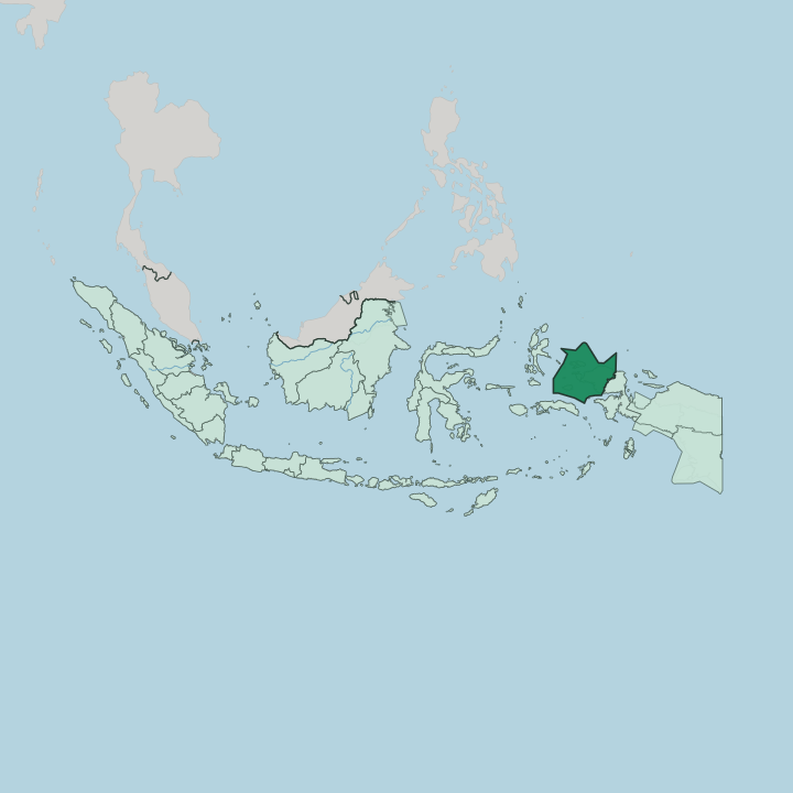
Towns & cities in Southwest Papua
Pick a town or city — each links to where to stay.
Two places anchor a trip. Sorong is the mainland base, where flights land and boats leave, and most spend a night there before or after the islands. The real destination is Raja Ampat.
Waisai, the small regency seat on Waigeo, is the ferry landfall and the closest thing the archipelago has to a town. Beyond it, choice comes down to water: the Dampier Strait homestays on Pulau Kri and Pulau Gam sit by the best-known dive sites, while Misool, far south, is remote and wild. Pick Sorong for logistics, the Dampier Strait for easy diving, and Misool if you want the reef to yourself.
About Southwest Papua
What is Southwest Papua known for?
Raja Ampat is the reason most outsiders know the province at all. The archipelago scatters more than fifteen hundred islands off the Bird's Head Peninsula, and its reefs hold more coral and reef-fish species than anywhere else yet surveyed on Earth. Divers come for that.
Sorong, the capital, is the working port they pass through, an oil-and-gas town on the New Guinea coast. Inland rise the Tambrauw Mountains and the sago swamps of the Moi homeland. The draw is the sea.
Where is Southwest Papua?
Southwest Papua sits at the far western end of New Guinea, wrapped around the northwestern tip of the Bird's Head Peninsula. The name misleads. It actually marks the northwest corner of Indonesian Papua, whatever the southwest in its name suggests.
The mainland is a tangle of coastal lowland, limestone karst and forested interior, rising inland to the Tambrauw Mountains that run along the northern coast. Sorong stands on the western shore, where the peninsula narrows toward the sea. West of it the land breaks apart into the Raja Ampat archipelago.
Those islands are the province's defining ground. Waigeo, Batanta, Salawati and Misool are the four largest, the 'four kings' that give Raja Ampat its name, and around them lie over fifteen hundred smaller islands, cays and reefs. The Dampier Strait threads between Batanta and Waigeo.
Its currents feed the reefs that made the region famous. These waters open west onto the Halmahera Sea and north toward the Pacific, at the heart of the Coral Triangle. Inland, away from the coast, the Maybrat highlands hold Lake Ayamaru and a scatter of villages reached only by rough road.
Sea defines this place. Everything else is edge.
What is Southwest Papua like?
This is Melanesian country, not Javanese. The people are Papuan, and the province holds more than fifty distinct ethnic groups across the Doberai lands, each with its own tongue. The Moi are the original people of Sorong and its hinterland.
Inland live the Maybrat, the Tehit and the Abun; the coasts and islands belong to the Ma'ya, the seafaring people from whom Raja Ampat's four kings were drawn. Papuan Malay ties them loosely together as a shared trade language, but dozens of local languages carry daily life. Sago is the staple, not rice.
People fell the palm, pound the pith and cook the starch into papeda, a glue-thick porridge eaten with fish. Christianity came with missionaries and shapes most village life, layered over older adat custom and clan law. Church and clan law coexist.
On Waigeo and the smaller islands, family-run homestays have opened the reefs to outsiders on local terms, and the money from a diver's bed goes straight to the clan that owns the reef. Land here is held by custom, reef by reef and forest by forest. Ownership is ancestral.
The sea is somebody's.
What is the history of Southwest Papua?
People have lived here for millennia. The painted hand stencils in the sea caves of Misool are thousands of years old. From the fifteenth century the Sultanate of Tidore claimed these coasts from its base in the Maluku islands to the west, ruling through the Raja Ampat 'four kings' it named as vassals.
Dutch colonial rule came later, and Indonesia took control of western New Guinea in the twentieth century. The province is new. Southwest Papua was split from West Papua and made Indonesia's thirty-eighth province in 2022, the end of a long push to move power closer to Sorong.
What is the climate of Southwest Papua?
The climate is equatorial and wet all year. Sorong sits just south of the equator, so heat and humidity barely shift between seasons, and the thermometer hangs close to the high twenties Celsius month after month. Rain is the only real variable.
The wettest months fall around the middle of the year, when the seas around Raja Ampat turn rougher and some homestays close. Diving conditions are calmest and clearest from around October to April. There is no cold season here.
Only wetter and drier.
How do you get to Southwest Papua?
One airport handles it all. Sorong's Domine Eduard Osok Airport is the entry point, fed by domestic flights from Jakarta, Makassar and Bali, with no direct international service. From the airport it is a short hop to the harbour.
Fast public ferries cross to Waisai on Waigeo twice a day, taking about two hours, while dive resorts send their own boats to meet arriving guests. There is no other way in but boat and plane. The reefs begin where the road ends.
Good for
Updated July 2026