Indonesia
Provinsi Kalimantan Barat, Indonesia — Towns & Travel Guide


West Kalimantan is Indonesia's stretch of western Borneo, where the equator crosses the Kapuas River delta at the port city of Pontianak.
About Provinsi Kalimantan Barat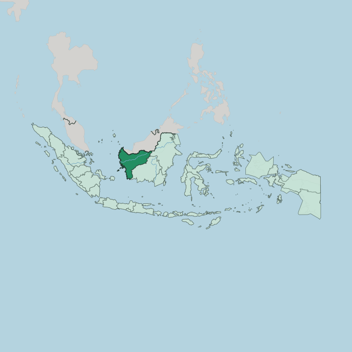
Towns & cities in Provinsi Kalimantan Barat
Pick a town or city — each links to where to stay.
Most trips base in Pontianak. Its hotels cluster along the Kapuas waterfront near Alun Kapuas park, an easy walk from the Istana Kadriah palace and the ferry piers, and that riverfront strip is where you want a room on a first visit. Singkawang, up the coast, suits a slower stay among its Chinese temples and beaches.
Sintang lies far upriver. Travellers pushing deep into the Kapuas basin or the Dayak longhouse country usually break the journey there before carrying on toward the interior.
About Provinsi Kalimantan Barat
What is Provinsi Kalimantan Barat known for?
Two things set West Kalimantan apart: the equator and the Kapuas. The equator runs straight through Pontianak, the provincial capital, which Indonesians call Kota Khatulistiwa, the Equator City, and mark with a monument standing on the river's north bank. The Kapuas River is the longest in Indonesia, threading the province from the interior mountains down to the South China Sea.
Its towns mix three peoples. Dayak, Malay, and Chinese families share the coast and the river, a blend that locals shorten to Tidayu. Singkawang, north along the shore, holds one of the country's biggest Cap Go Meh parades each lunar new year.
Where is Provinsi Kalimantan Barat?
Borneo carries the province on its western shoulder. Malaysia's Sarawak sits over the northern border, Central Kalimantan adjoins the east, and the Karimata Strait and South China Sea wash a long coast that faces the Natuna islands across the water. The equator slices it almost in two.
Near the shore the land lies flat, a belt of swamp, peat, and mangrove drained by slow brown rivers. Inland it rises. Forested hills step up toward the Müller mountains at the centre of the island, where the province meets its neighbours along the watershed.
Everything here drains to the Kapuas. The Kapuas River is the longest in Indonesia, gathering the Landak, Melawi, and Sekayam before spilling into a broad, marshy delta beside Pontianak, where the port and the equatorial monument stand together on the water. River boats work far upstream.
They reach Sintang and the lake country of Danau Sentarum in the far interior, where roads give out and the water becomes the road. South of the delta, rainforest still holds at Gunung Palung, one of the last strongholds of wild orangutans on the island.
What is Provinsi Kalimantan Barat like?
Three peoples make the province what it is. Dayak communities of the interior, Malay settlements of the coast and rivers, and Chinese families descended from Hakka gold miners have lived alongside each other for generations, a mix locals fold into one word, Tidayu. Their faiths sit side by side.
Mosque, church, and Chinese temple often share the same street in Pontianak and Singkawang, and the calendar carries Ramadan, Christmas, the Dayak Gawai harvest, and the lunar new year alike. Singkawang wears the Chinese heritage most openly. Its skyline runs to temple roofs and incense smoke, and at Cap Go Meh, fifteen days after the new year, tatung mediums parade through the streets pierced with skewers in a rite drawing crowds from across the country.
The Dayak keep older ways upriver. Longhouses still stand in some interior villages, and the Gawai festival marks the rice harvest with rice wine, gongs, and dance passed down the generations. Indonesian ties it together as the shared tongue, spoken over Malay, Hakka, and a scatter of Dayak languages at home.
Batik here blends all three, its insang motif drawn from the gills of Kapuas fish.
What is the history of Provinsi Kalimantan Barat?
Malay sultanates came first. Sambas took shape in 1609 and Mempawah followed, and in 1771 an Arab-descended trader, Syarif Abdurrahman, founded Pontianak where the Landak joins the Kapuas. Then came the Chinese.
Hakka miners brought in to dig the gold fields around Sambas organised into self-governing kongsi, and one of them, the Lanfang Republic, ran its own courts, army, and coinage from 1777 until the Dutch crushed it in 1884. Dutch rule absorbed the sultanates, and West Kalimantan became an Indonesian province in 1957.
What is the climate of Provinsi Kalimantan Barat?
The equator keeps it hot and wet all year. West Kalimantan sits under a tropical rainforest climate, with heavy afternoon downpours, high humidity, and warm days that change little between the seasons. There is no true dry season.
Rain falls hardest from October to December, when the shift of the equatorial rain belt pushes storms across Borneo, and eases a little between June and August. Pontianak counts among the wetter cities in Indonesia.
How do you get to Provinsi Kalimantan Barat?
Most arrivals land at Pontianak. Supadio International Airport, just south of the city, takes the flights from Jakarta and other Indonesian hubs, and the odd international route across to Kuching in Malaysia. Overland, one road matters.
The Trans-Kalimantan highway runs east and north from Pontianak toward Singkawang and the border post at Entikong, the crossing that links West Kalimantan by bus to Kuching and the rest of Sarawak. The rivers still carry people too. Boats leave the Pontianak wharves up the Kapuas for Sintang and the upcountry towns, slower than the road but sometimes the only way in.
Good for
Updated July 2026