Indonesia
Provinsi Lampung, Indonesia — Towns & Travel Guide


Lampung fills the southern tip of Sumatra, where ferries from Java dock and wild elephants still roam the rainforest at Way Kambas.
About Provinsi Lampung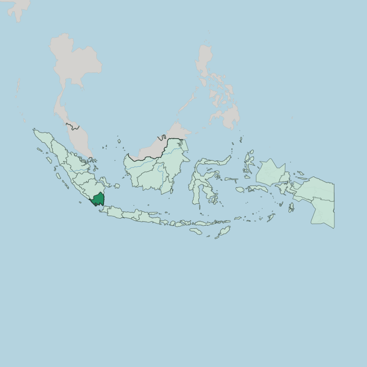
Towns & cities in Provinsi Lampung
Pick a town or city — each links to where to stay.
Most trips begin in Bandar Lampung. The provincial capital sits at the head of Lampung Bay, close to Radin Inten II Airport, and holds the widest choice of hotels before the roads thin out into the countryside. South toward Bakauheni, Kalianda sits within reach of the boats out to Krakatoa.
Offshore, Pahawang and the bay at Kiluan trade hotels for stilt homestays and fishermen's boats. Surfers keep going. The break at Tanjung Setia faces the open Indian Ocean, best in the dry-season months.
About Provinsi Lampung
Wild elephants draw most visitors.
What is Provinsi Lampung known for?
Way Kambas National Park shelters one of Sumatra's last herds of wild Sumatran elephants, along with the critically endangered Sumatran rhino, deep in the lowland rainforest of the eastern coast. Off the southern coast, ferries from Bakauheni cross the Sunda Strait to Java, the busiest sea link in the country. Krakatoa still smokes in that strait.
Inland, the volcanic slopes grow robusta coffee and black pepper, two crops that carry the province's name to market.
Where is Provinsi Lampung?
Lampung caps the southern end of Sumatra. The Barisan Mountains run the length of the province from northwest to southeast, their spine broken by volcanic cones that rise above the western coast. Coffee gardens climb those volcanic slopes above the towns of the interior.
West of the ridge, the land falls to the Indian Ocean. East of it, a broad lowland of rice fields and swamp runs down to the Java Sea. Three rivers cross it.
The Sekampung, the Seputih and the Tulang Bawang all rise in the mountains and drain eastward across the plain. The southern edge is all water. Across the Sunda Strait, only a narrow channel of sea separates Lampung from Java and the sea approach to Jakarta, and the drowned caldera of Krakatoa still smokes midway between the two coasts.
Long beaches and coral shoals line the Indian Ocean coast to the west, broken by bays at the foot of the descending mountains. South Sumatra lies over the northern border, with Bengkulu to the northwest. The capital, Bandar Lampung, stands at the head of Lampung Bay on that southern shore, where the ferry port of Bakauheni faces the strait.
What is Provinsi Lampung like?
Lampung is not one people. The indigenous Lampungese split into two branches, the inland Pepadun of the highlands and the coastal Saibatin of the shore, each with its own dialect and body of customary law. Their code of conduct is Piil Pesenggiri, a Lampungese ideal of honour, hospitality and open-handed generosity toward guests.
The horned golden crown called the siger stands as the emblem of the province, moulded onto gateways and bridal headdresses alike. Weavers still work the old cloth. Tapis, stitched with gold thread, and the ceremonial ship-cloths of the coast rank among the finest textiles in Sumatra.
Most people here are not Lampungese at all. Waves of settlers from Java, Bali and West Java arrived under the colonial and later Indonesian transmigration schemes, until Javanese speakers became the clear majority across the province. Their villages carry Javanese names and grow Javanese rice.
The Lampung language has slipped toward the edge of survival as a result, kept alive mainly by elders and by school revival classes. Indonesian ties the whole patchwork together. That mix of Sumatran adat and Javanese custom is what gives the province its particular character.
What is the history of Provinsi Lampung?
Pepper made Lampung's name long before Indonesia existed. Its coastal ports shipped black pepper north to the Banten Sultanate on Java, whose sultans drew much of their wealth from the Lampung crop. Then the strait exploded.
When Krakatoa erupted in 1883, its tsunami swept the southern coast and remade the shoreline around the Sunda Strait. Dutch planners opened the first transmigration colony at Gedong Tataan in 1905, seeding the Javanese influx that would reshape the province. Lampung became a province in its own right in 1964, carved from South Sumatra.
What is the climate of Provinsi Lampung?
Lampung is hot and wet all year. It has a tropical monsoon climate, with the heaviest rain falling between November and May and January and February the wettest stretch. The middle of the year turns drier.
Those dry months, roughly June to September, are the season for surfing the west coast and taking boats across calm water to the islands. Rain is heaviest on the Barisan slopes, where the downpours that feed Bukit Barisan Selatan's rainforest keep the western hills green.
How do you get to Provinsi Lampung?
Flights land at Radin Inten II Airport. The airport sits just north of Bandar Lampung, a short hop from Jakarta across the Sunda Strait. The overland route is the old one.
Buses and trains run down Java to the port at Merak, where ferries cross the strait to Bakauheni on the Lampung shore before the road turns north into the interior. From Bakauheni the Trans-Sumatran toll road climbs north toward South Sumatra and the rest of the island.
Good for
Updated July 2026