Indonesia
Sulawesi Tenggara, Indonesia — Towns & Travel Guide


Sulawesi Tenggara is the south-eastern arm of Sulawesi, an Indonesian province of nickel hills, the Buton Sultanate, and the Wakatobi dive reefs.
About Sulawesi Tenggara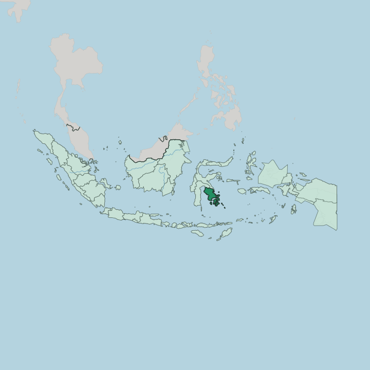
Towns & cities in Sulawesi Tenggara
Pick a town or city — each links to where to stay.
Kendari is where most trips begin. The capital sits on the east coast, holding the province's main airport and ferry port, and it links the mainland peninsula to the scattered islands offshore. Divers carry on to Wakatobi, where the dive resorts of Wangi-Wangi and Tomia line the edge of the marine park.
History pulls travellers south to Baubau, under the ramparts of the Wolio fort that once ruled the Buton Sultanate. Muna stays quiet. Its pull is the prehistoric cave art in the hills near Raha.
Base yourself in Kendari to land and resupply, then choose an island for the thing you came to see.
About Sulawesi Tenggara
What is Sulawesi Tenggara known for?
Two things carry the province's name. Under the sea, the Wakatobi reefs draw divers to the coral walls of the Tukang Besi islands, where the Banda Sea meets some of the densest reef life in the Coral Triangle. On land, the story is nickel and asphalt: the laterite hills of Kolaka and Konawe feed Indonesia's smelters, while Buton Island holds the country's only mined deposits of natural asphalt.
Baubau guards the old Buton Sultanate, its hilltop fort among the largest in the world. Kendari, the capital, ties the peninsula to the islands.
Where is Sulawesi Tenggara?
Sulawesi Tenggara occupies the south-eastern arm of Sulawesi, one of the four Greater Sunda Islands. The mainland is a long peninsula, ribbed by two ranges: the Mekongga Mountains in the north-west and the Tanggeasinua range down its spine. Mount Mekongga is the highest point, a limestone massif above the nickel country of Kolaka and Konawe.
Rivers like the Lasolo and the Sampara drain the interior toward the coast. Off the coast lie the province's islands. Buton and Muna sit closest, large and settled; Kabaena and Wawonii ride the smaller channels; and further out, the Wakatobi group scatters across open water.
Water defines the province as much as land. The Gulf of Boni cuts in from the west, separating the peninsula from the rest of Sulawesi, while the Banda Sea washes the eastern and southern islands and gives the Wakatobi reefs their depth. Kendari lies on the east coast, wrapped around the narrow inlet of Kendari Bay.
Baubau faces the strait between Buton and Muna, on one of the old sea roads between Makassar and the Maluku islands. Little of the province sits far from salt water. The peninsula is only ever a few ranges wide, and the sea is never distant.
What is Sulawesi Tenggara like?
Three peoples share the province. The Tolaki hold the mainland peninsula, farmers and fishers of the Konawe and Kolaka lowlands, and their reach still maps onto the old geography. The Butonese and the Muna come from the southern islands, seafarers whose boats and trade once reached across the eastern archipelago.
Bajau sea nomads still moor their stilt villages over the Wakatobi shallows. Islam arrived with the sultanates and stayed; it shapes the calendar in nearly every village. Older layers survive underneath, in weaving, in metalwork, and in the court rituals kept alive around Baubau's fort.
Language marks the divide most sharply. Tolaki is spoken across the mainland, Muna and Wolio on the islands, alongside the Indonesian that ties the country together. One tongue took an unusual turn.
Cia-Cia, spoken by a community near Baubau, adopted the Korean Hangul alphabet in 2009 to put its long-unwritten language on the page. That experiment made a small Buton town briefly famous far beyond Sulawesi. Handloom weaving remains a living craft in the island villages here, and the Wolio fort above Baubau still anchors the ceremonies that recall the Buton Sultanate.
What is the history of Sulawesi Tenggara?
Buton Island carried the region's oldest state. A Wolio kingdom took shape there around 1332, and in 1540 its ruler converted to Islam and took the title of sultan, beginning the Buton Sultanate. For four centuries the sultanate ran the southern islands under its own written constitution, ruled from the hill fort at Wolio above Baubau.
Kendari and the Tolaki mainland stayed a world apart, drawn only slowly into the same orbit. The modern province is young. Sulawesi Tenggara was cut from South Sulawesi and made a province in its own right in 1964.
What is the climate of Sulawesi Tenggara?
Sulawesi Tenggara sits deep in the tropics, warm and humid the year round. Two monsoons set the rhythm. The wet season runs from November to April, when the western monsoon drives rain across the peninsula and the heaviest downpours fall on Kolaka and the ranges.
Drier air follows from May to October, the better window for the Wakatobi crossing and for diving the Banda Sea. Rain is never truly absent. The islands, ringed by warm sea, stay a shade milder and wetter than the interior around Konawe.
How do you get to Sulawesi Tenggara?
Almost everyone flies in through Kendari. Haluoleo Airport, out at Ranomeeto beyond the city, links the capital to Makassar, Surabaya and Jakarta, with the hop from Makassar taking about an hour. Reaching the islands then means a second leg.
Small planes and ferries run on to Baubau on Buton, while the Wakatobi divers fly or sail out to Wangi-Wangi. Overnight Pelni ships still thread the old route past Baubau between Makassar and the Maluku ports. From Kendari, the sea takes over where the roads run out.
Good for
Updated July 2026