Armenia
Armavir, Armenia — Towns & Travel Guide


Armavir is Armenia's smallest province, holding Etchmiadzin, the mother church of the Armenian Apostolic faith, on the Ararat plain.
Find your area →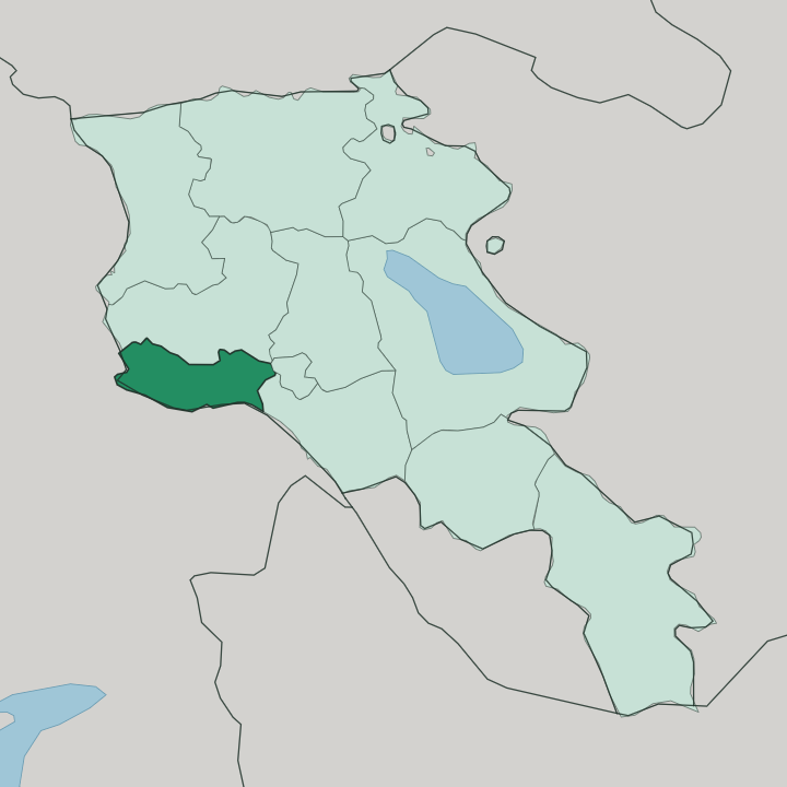
Towns & cities in Armavir
Pick a town or city — each links to where to stay.
Most travellers see Armavir on a half-day out from Yerevan, which sits just east of the province. Vagharshapat is the exception worth an overnight. Guesthouses and small hotels cluster within a short walk of the cathedral precinct, and staying there lets you reach the churches before the tour coaches arrive.
The provincial town of Armavir itself, farther west toward the Aras river, is a working agricultural centre with little for visitors. Base yourself in Vagharshapat if the pilgrimage sites are the reason you came; otherwise Yerevan makes the easiest hub for everything on the plain.
About Armavir
Armavir is where Armenia became Christian.
What is Armavir known for?
Vagharshapat, the province's largest city and long known as Etchmiadzin, holds the Mother See of Holy Etchmiadzin, seat of the Armenian Apostolic Church and one of the oldest cathedrals anywhere. Nearby stand the ruined seventh-century rotunda of Zvartnots Cathedral and the Bronze Age mound of Metsamor, both spread across the flat Ararat plain. The land is the country's vineyard, too, and the province supplies most of Armenia's grapes and apricots from its irrigated fields.
Where is Armavir?
Armavir sits in western Armenia, on the Ararat plain just west of the capital, Yerevan. It is the country's smallest province, and the flat, irrigated plain is its whole character, ringed by high mountains that never let you forget where you stand. Two peaks fix the view.
Mount Ararat rises to the south, across the Aras river in Turkey, its snow cone dominating every clear line of sight from the fields below. Mount Aragats, the highest summit inside Armenia, closes off the north. Between them the land lies open and worked.
The Aras river draws the southern and western edge of the province, and along that water runs the closed frontier with Turkey, facing the provinces of Kars and Iğdır. The plain sits high. It lies roughly a kilometre above the sea, which is why the summers scorch and the winters bite hard despite the low, level ground.
Vagharshapat and the smaller provincial town of Armavir both stand out here on the plain. Yerevan lies just over the eastern boundary, close enough that the two run together in daily traffic.
What is Armavir like?
Faith gives Armavir its centre of gravity. Vagharshapat is the spiritual capital of the Armenian people, and the compound of Holy Etchmiadzin, with its adjoining churches of Saint Hripsime and Saint Gayane, still draws pilgrims and the ordination of clergy for the whole Armenian Apostolic Church. On feast days the town fills.
The language spoken across the province, as across the country, is Armenian, written in its own alphabet devised in the early fifth century. That script is carved into the old khachkars, the stone cross-slabs, that stand in the churchyards here. Outside the sacred sites, the culture is agricultural and unhurried.
This is grape and apricot country, and the harvest and the making of wine and brandy run deep in local life. Roadside stalls sell the fruit of the plain in season. Metsamor, the settlement mound west of Vagharshapat, carries that continuity back to the Bronze Age, when farmers and metalworkers first worked this same ground.
The old and the everyday sit close together. A ruined cathedral and a working vineyard can share one horizon.
What is the history of Armavir?
The province takes its name from ancient Armavir, one of the early royal capitals of Armenia before Christ. History turned decisive in the year 301. Tradition holds that the Armenian king embraced Christianity that year, and Gregory the Illuminator raised the first cathedral at Vagharshapat, then the seat of the realm.
The great rotunda of Zvartnots followed in the seventh century. It stood for some three hundred years before it fell, most likely thrown down in one of the earthquakes that shake this plain. The modern province was drawn up in 1995, gathering these lands under one administration.
What is the climate of Armavir?
Armavir has a dry, sharply continental climate. Summers on the Ararat plain are long and fierce, and the sun can push afternoon temperatures well past 40 degrees in July and August, when the irrigated fields depend entirely on water drawn from the Aras river. Winters swing the other way, short but genuinely freezing, cold enough that some growers bury their vines against the frost.
Rain is scarce all year, so the greenery you see is watered by hand and canal rather than by the sky. Spring, when the apricot blossom breaks, is the kindest season to visit.
How do you get to Armavir?
You arrive through the airport. Zvartnots International, Armenia's main gateway near Yerevan, sits inside the province itself, so most visitors are already on Armavir soil the moment they land. From Yerevan the drive west to Vagharshapat takes well under an hour, and marshrutka minibuses run the route cheaply from the capital's Kilikia station.
Within the province, roads fan out across the flat plain toward the town of Armavir and the Aras river frontier. The border with Turkey along that river is closed, so all travel comes and goes through Yerevan.
Common questions
What is the best area to stay in Armavir?
Yerevan: day trips across Armavir without changing hotel.
Good for
Updated July 2026