Armenia
Tavush, Armenia — Towns & Travel Guide


Tavush is the forested northeast corner of Armenia, where the Aghstev river runs past Dilijan and Ijevan toward Georgia.
About Tavush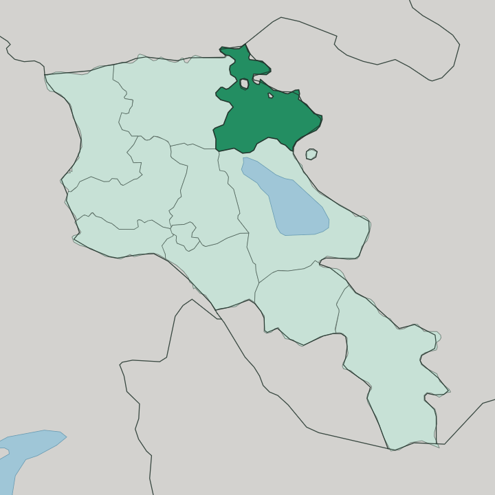
Towns & cities in Tavush
Pick a town or city — each links to where to stay.
Three towns anchor a stay. Dilijan is where most travellers base themselves, a wooded resort town on the Aghstev inside the national park. Ijevan, the provincial capital downstream, is the working hub and transport pivot.
Berd sits far to the east, remote in the Shamshadin hills near the Azerbaijan border. Pick Dilijan if you want forest walks and mineral springs on your doorstep; choose Ijevan when you need the bus connections and the market town; head to Berd only for the quiet, empty valleys of the eastern edge.
About Tavush
What is Tavush known for?
Tavush is Armenia's green province. Thick mixed forest covers most of it, the densest woodland the country holds, wrapped around the resort town of Dilijan and the provincial seat at Ijevan. Medieval monasteries sit deep in that forest: Haghartsin above Dilijan and Goshavank in the village of Gosh, both raised between the tenth and thirteenth centuries.
Dilijan draws walkers into its national park, where Lake Parz and Lake Gosh lie among the trees. Locals call the district a little Armenian Switzerland, and the mineral springs that made Dilijan a spa town are the reason.
Where is Tavush?
Tavush fills the northeast of Armenia, a wedge of the Lesser Caucasus tilted toward two borders. Georgia runs along its northern edge. To the east, Azerbaijan holds the whole length of the far side.
The mountains here fold into steep, forested valleys rather than the bare volcanic plateaus of central Armenia. Ridges climb close to three thousand metres in the east, while the valley floor drops toward the Debed near the Georgian frontier. That relief is why the province stays green.
The Aghstev river is the spine of the settled part. It gathers in the mountains, cuts down through Dilijan, and passes Ijevan before crossing into Azerbaijan, where it feeds the Kura on the long run to the Caspian. The Getik joins it from the south.
Away to the east, past a high dividing ridge, the Tavush river drains its own set of valleys around Berd, a district long known as Shamshadin. Lake Parz and Lake Gosh sit in the forest above Dilijan, small and clear. Woodland covers roughly half of the whole province, the richest belt of it wrapping Dilijan, Ijevan and Berd.
The Sevan basin lies just over the mountains to the south, and the road in from the capital climbs past that lake before dropping into the trees.
What is Tavush like?
Faith is carved into the hillsides here. The great monasteries of Tavush were monastic and scholarly centres of medieval Armenia, and they still anchor how the province sees itself. Haghartsin, above Dilijan, grew church by church between the tenth and thirteenth centuries, its refectory and cross-stones set among beech and oak.
Goshavank carries the name of Mkhitar Gosh, the scholar who compiled Armenia's first law code and rebuilt the monastery in the village that now bears his name. These were places of learning as much as worship. Dilijan added a second layer to that heritage.
From the second half of the nineteenth century it drew the Russian imperial elite up to its mineral springs, and painters, composers and writers followed the water into the woods. That artistic reputation still clings to the town. The everyday culture of the province turns on forest and orchard, on walnut groves and small mountain villages, on tonir bread and homemade fruit vodka poured for guests.
Armenian is the common tongue, written in its own alphabet. Berd and the eastern valleys keep the older, harder rhythm of a frontier country, where daily life is shaped by the nearness of the border. The forest holds all of it together.
What is the history of Tavush?
The name is medieval. It first appears in the ninth century as a Bagratid fortress standing near what is now Berd, and it spread from that stronghold to the whole surrounding land. Through the medieval centuries the district was monastery country, and Haghartsin and Goshavank rose while the region passed between Armenian and neighbouring powers.
The modern province is far younger. Tavush took its present shape in 1995, when the administrative reform of independent Armenia merged three former Soviet districts into a single marz named for that old fortress.
What is the climate of Tavush?
The forest sets the terms. Because the province sits lower and wetter than the Armenian plateau, its valleys stay green under a warm-summer humid continental climate rather than the dry heat of the interior. Dilijan is the mildest corner, cool even in high summer under its tree cover, cold and snowbound in winter.
Rain and mountain springs feed the woodland the year round. The trekking season runs from late spring, once the passes clear, into the golden weeks of autumn.
How do you get to Tavush?
The way in climbs over a mountain. The main road from Yerevan runs up past Lake Sevan and bores through the Sevan-Dilijan tunnel, dropping travellers straight into the forest at Dilijan before it carries on down the Aghstev to Ijevan. Marshrutka minibuses run that route daily from the capital.
The same highway is the trunk line north to Georgia, crossing the frontier at Bagratashen for Tbilisi, so through-traffic between the two countries passes the length of the province. Within Tavush, roads follow the river valleys, and the eastern towns around Berd sit at the end of longer mountain drives.
Good for
Updated July 2026