Armenia
Kotayk, Armenia — Towns & Travel Guide


Kotayk is Armenia's landlocked heart, where the Gegham mountains rise above Garni temple and the Tsaghkadzor ski slopes.
Find your area →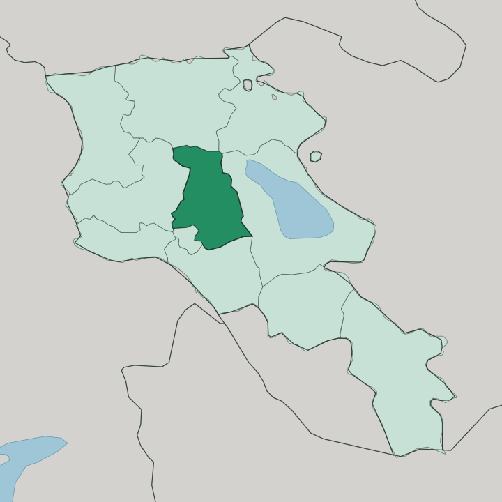
Towns & cities in Kotayk
Pick a town or city — each links to where to stay.
Tsaghkadzor is the obvious base. Its spa and ski hotels cluster below the Kecharis monastery and the cable-car station, filling up in the snow season. Abovyan, the largest town, sits close enough to Yerevan to work as a commuter-belt stopover rather than a destination in itself.
Hrazdan, the administrative capital, lies further up the river and keeps a quieter feel. Many travellers skip beds in the province and day-trip out from Yerevan, half an hour south. Choose Tsaghkadzor for the mountains and the snow on your doorstep; use Yerevan when you mean to see Garni and Geghard on one loop and sleep in the city.
About Kotayk
What is Kotayk known for?
Kotayk packs Armenia's most-photographed sights into one small province north-east of Yerevan. The first-century Garni temple stands on a promontory above the Azat gorge, the only Greco-Roman colonnaded building left in the country. A short drive up the valley reaches Geghard, a monastery half cut from the living rock.
Winter changes the pace entirely. Snow draws skiers to Tsaghkadzor, where a cable car climbs the wooded flank of Mount Teghenis to slopes above the town.
Where is Kotayk?
Kotayk sits in the middle of Armenia, wrapped around the northern approaches to Yerevan. It touches no foreign border. That makes it the only one of Armenia's provinces held entirely inside the country, ringed by Lori and Tavush to the north, Gegharkunik to the east, Aragatsotn to the west, and Ararat with the capital to the south.
The land tilts up as you move inland from the city. Most of the settled province lies on the Kotayk plain, a tableland between the Hrazdan and Azat rivers that runs from roughly 1,200 to 1,500 metres above sea level. The Hrazdan cuts a gorge down its western edge on the way to Yerevan.
To the north-east the ground climbs into the volcanic Gegham mountains, crowned by the extinct cone of Azhdahak, with the isolated peaks of Hatis and Gutanasar standing apart on the plateau. Forested ridges of the Tsaghkunyats range close off the north-west above Tsaghkadzor. It is a province of stone and altitude rather than open water, and the mountains are never out of sight.
What is Kotayk like?
Kotayk carries two Armenias at once, the pagan and the Christian, within a few kilometres of each other. Garni is the older face. Its colonnaded temple to the sun-god Mihr, raised in the first century, survived the country's conversion and a 1679 earthquake to be rebuilt from its own fallen stones.
Just upstream, the rock-cut chapels of Geghard turn the same cliffs into a Christian sanctuary, and Armenians treat both as national touchstones. Monastery-building runs through the province's story. At Tsaghkadzor the Kecharis complex was founded in 1033 by Grigor Magistros of the Pahlavuni family, a line of princes who fortified this stretch of the Hrazdan valley.
The everyday culture is Armenian and Christian, the church being the Armenian Apostolic, and Armenian is the language you hear in the towns. Smaller communities colour the villages, among them Yazidis and Russian Molokans who settled the highlands generations ago. Kotayk also lends its name to Armenia's best-known beer, brewed at Abovyan and poured the length of the country.
What is the history of Kotayk?
The name is ancient, borrowed from the Kotayk canton of the old Ayrarat province and recorded by Ptolemy as Kotakene. Persia held this land through the Erivan Khanate until the Treaty of Turkmenchay handed Eastern Armenia to the Russian Empire in 1828. Most of its towns are young.
Charentsavan and Hrazdan and Abovyan were all laid out as Soviet industrial settlements after the Second World War, and the province in its present shape was drawn only in 1995, when three older districts were merged into one.
What is the climate of Kotayk?
In Kotayk it is the height of the land that rules the seasons. The lower south, nearer Yerevan, runs dry and semi-arid, while the higher centre and north turn cold and snowy in winter. Tsaghkadzor, up around 1,840 metres in the Tsaghkunyats forests, holds enough snow to run a ski season while the plain below stays brown.
Summers on the Kotayk plateau are warm but shorter and fresher than in the Ararat lowlands, and the mountain nights cool off fast once the sun drops behind the Gegham ridges. Dry below, snowbound above.
How do you get to Kotayk?
There is no airfield anywhere in Kotayk. Nearly everyone lands at Zvartnots outside Yerevan and drives out from there, since the whole province wraps tightly around the capital's northern edge. The M-4 motorway is the spine, running up through Abovyan and Hrazdan toward Sevan.
Marshrutka minibuses shuttle between Yerevan and the Kotayk towns through the day. For Garni and Geghard you turn east off the highway into the Azat gorge, half an hour from the city.
Common questions
What is the best area to stay in Kotayk?
Yerevan: day trips to Garni and Geghard.
Good for
Updated July 2026