Armenia
Syunik, Armenia — Towns & Travel Guide


Syunik is Armenia's mountainous southern province, holding the Zangezur peaks, Tatev monastery and the only road down to the Iranian border.
About Syunik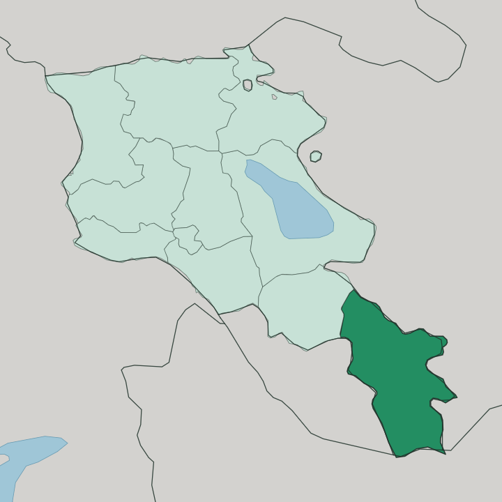
Towns & cities in Syunik
Pick a town or city — each links to where to stay.
Goris is the natural first base. Its 19th-century stone houses and the cave-riddled Khndzoresk gorge sit close to the Wings of Tatev cable car, so most trips start here. Kapan, the capital, lies further south in the Voghji valley beneath Mount Khustup, better placed for the deep south and long treks in the Zangezur range.
Sisian holds the high plateau near the Zorats Karer megaliths, cooler and more open than the gorges below. Meghri is the warm outlier, an orchard town on the Iranian frontier where beds are few. Pick Goris for monasteries; go south for mountains and the border.
About Syunik
Syunik is the southern tip of Armenia.
What is Syunik known for?
The Zangezur Mountains run the whole length of the province, and Mount Kaputjugh crowns them at 3,906 metres, the highest ground in the country outside the Aragats massif. Its signature sight is Tatev Monastery, a fortified 9th-century foundation perched above the Vorotan gorge. Most reach it by cable car.
The Wings of Tatev glides across the canyon from Halidzor, and below it Kapan, the provincial capital, sits deep in the mining valleys.
Where is Syunik?
Syunik is the southernmost of Armenia's provinces, a long finger of highland that reaches down to the Iranian border. The Zangezur Mountains fill most of it. This range runs unbroken from the Vardenis heights in the north toward the Arax valley in the south, and it carries the province's highest summits, Mount Kaputjugh at 3,906 metres and Mount Gazanasar close behind.
Forests climb the slopes below. Rivers cut the ranges into deep gorges: the Vorotan drains the northern plateau around Sisian, while the Voghji carves the mining valleys around Kapan further south. Four borders hem the province in.
Vayots Dzor lies to the north, the Nakhchivan exclave to the west, the highlands of Nagorno-Karabakh to the east, and Iran to the south across the Arax. At its narrowest the province is only a strip of land, and that strip is the sole overland link between the rest of Armenia and Iran. The single north-south highway threads the whole length of it, climbing and dropping through the passes.
Meghri sits at the far end, in the warmest and lowest ground, where orchards grow along the river. Kapan holds the middle. The land never really flattens out anywhere.
What is Syunik like?
Syunik wears its faith in stone. The great symbol is Tatev Monastery, a fortified 9th-century complex on a basalt spur above the Vorotan gorge that once ran a famous medieval university and served as the spiritual seat of the whole region. Monasteries and half-ruined fortresses stud the slopes around it.
Older still are the megaliths. Near Sisian stands Zorats Karer, a field of upright basalt stones pierced with holes that locals call the Armenian Stonehenge, raised in the Bronze Age long before any church. The living culture is rural and mountain-shaped.
Villages guard their own cooking, and the tables of Syunik are known for Goris beans, herb-stuffed dolma, and cheeses buried to age in clay jars. Hospitality is close and unhurried here. The common tongue is Armenian, as across the country, and the province keeps a strong sense of its own frontier identity, forged by centuries of standing at the edge.
Old cave dwellings honeycomb the gorge at Khndzoresk near Goris, once lived in, now reached by a swaying footbridge above the ravine. Copper and molybdenum mining shapes the working towns as much as any monastery. Both belong to the character of the place.
What is the history of Syunik?
Syunik counts among Armenia's most ancient ground. The Siunia dynasty held these highlands as Armenian nobles from antiquity, and Persian rulers knew the district as Sisakan. In 987 its lords broke free of the crumbling Bagratid crown and founded the independent Kingdom of Syunik, which held its own until 1170 and made Tatev Monastery its spiritual heart.
Russian administration later renamed the core district Zangezur, the name still attached to its mountains. The modern province was drawn in 1995.
What is the climate of Syunik?
Altitude rules the weather in Syunik. The high plateau around Sisian and the Zangezur peaks runs cold, with hard winters that can drop well below freezing and short cool summers. Drop south into the valleys and it flips.
Meghri and the low ground near the Arax turn hot and dry in summer, warm enough for the fruit orchards and pomegranates that grow along the river. Snow closes the high passes for much of winter, so the season shapes any trip.
How do you get to Syunik?
Almost everyone drives down from Yerevan. The single north-south highway runs some 250 kilometres to Goris and takes four hours or more, climbing through the passes of Vayots Dzor before it enters the province. Marshrutka vans and buses cover the same route from the capital's southern bus station.
A rental car is easier for reaching Tatev and the far south. Small flights have returned between Yerevan and Kapan, cutting the mountain journey to under an hour.
Good for
Updated July 2026