Armenia
Gegharkunik, Armenia — Towns & Travel Guide


Gegharkunik is the largest province of Armenia, wrapped around Lake Sevan, the great alpine lake of the Caucasus.
About Gegharkunik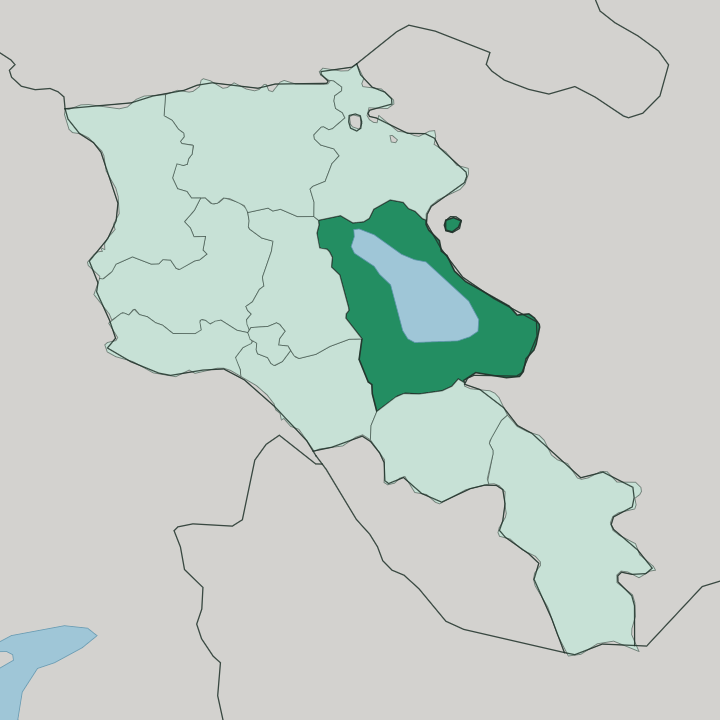
Towns & cities in Gegharkunik
Pick a town or city — each links to where to stay.
Sevan is the natural first base. The nearest lakeside town to Yerevan, it sits at the neck of the peninsula where Sevanavank stands, and most lake trips begin there. The rest of the province strings out along the shore.
Gavar, the provincial capital, keeps to the quieter western side within reach of the Noratus khachkars. Martuni holds the southern shore below the Vardenis mountains, while Vardenis anchors the far eastern end near the old Azerbaijan border. Choose Sevan for the monastery and a first visit; take Gavar or the southern shore to have the lake without the day-trip crowds.
About Gegharkunik
Lake Sevan defines this province.
What is Gegharkunik known for?
It fills the central basin and covers nearly a quarter of the whole territory, the largest body of fresh water in the Caucasus and one of the great alpine lakes of Eurasia. Gavar is the provincial capital, and Sevan the largest town, both built on the shores. The ninth-century monastery of Sevanavank crowns a peninsula that was once an island.
At Noratus stands the largest field of khachkars in Armenia. Fishermen still work the lake for the Sevan trout the locals call ishkhan.
Where is Gegharkunik?
Gegharkunik is the largest of Armenia's provinces, and its whole shape is dictated by one lake. Lake Sevan sits high on a plateau in the country's east, ringed by mountains and open sky. The Gegham range rises to the west, a wall of extinct volcanoes, while the Vardenis mountains close off the south.
Twenty-eight rivers and streams pour down off those slopes into the lake. Only one river leaves it. The Hrazdan drains a tenth of the inflow westward toward Yerevan, and the rest simply evaporates into the thin highland air.
The eastern edge of the province runs up against the border with Azerbaijan. Gavar, the capital, stands back from the water on the western shore, with Sevan to its north and Martuni to the south. Vardenis lies further east, near the far end of the lake.
Everything here bends toward the water.
What is Gegharkunik like?
The lake shapes the culture as much as the land. Monasteries mark its shores. Sevanavank was founded in 874 by Princess Mariam, daughter of the Armenian king Ashot I, on what was then an island; Stalin-era draining dropped the water some 20 metres and joined it to the mainland as a peninsula.
Below Gavar, in the churchyard at Noratus, hundreds of khachkars crowd the grass, carved memorial stones whose oldest examples reach back to the late tenth century. This is old Armenian ground. Movses Khorenatsi, the early historian, traced the province's name to Gegham, a descendant of the patriarch Hayk.
Fishing and herding still order daily life around the water, and the ishkhan trout of Lake Sevan remains a prize on any table nearby.
What is the history of Gegharkunik?
Long before the monasteries, this basin held a small kingdom the Urartians called Uelikuni. Urartu conquered it in the eighth century BCE, and its name survives in cuneiform. The medieval historian Movses Khorenatsi tied the district to Gegham, a descendant of the legendary patriarch Hayk, and the name Gegharkunik carries that lineage.
Sevanavank rose on its island in 874. Under Soviet rule the lake itself became the story, as engineers drained it for irrigation and power and dropped its level far enough to expose old shorelines and strand the monastery on dry land.
What is the climate of Gegharkunik?
This is one of the coldest inhabited corners of Armenia. Sitting high on the Sevan plateau, the province runs to long, snowbound winters and short, cool summers, a continental rhythm sharpened by the altitude. Frost bites hard from November.
Ice forms across bays of the lake in January and February, and the surrounding peaks hold snow late into spring. Summer softens things only briefly, and even in July the lake water rarely climbs past a bracing chill. Swimmers wade in anyway.
How do you get to Gegharkunik?
Most travellers reach Gegharkunik on the M4 highway out of Yerevan. The road climbs north-east through dry, treeless hills for about an hour, cresting a pass before the whole of Lake Sevan opens out on the plateau below. Sevan, the nearest lakeside town, lies some 65 kilometres from the capital.
A shore road rings the water. From there it carries on to Gavar, Martuni and Vardenis, threading the villages and monasteries strung along the lake. The trip makes an easy day out of Yerevan.
Good for
Updated July 2026