Indonesia
Nanggroe Aceh Darussalam Province, Indonesia — Towns & Travel Guide


Aceh fills the northern tip of Sumatra, Indonesia's westernmost province, edged by the Indian Ocean and ruled under Islamic law.
About Nanggroe Aceh Darussalam Province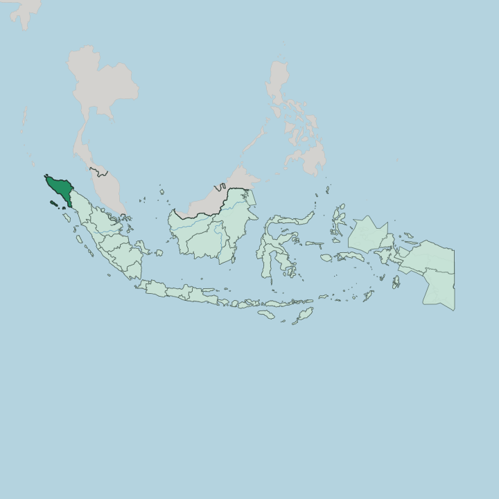
Towns & cities in Nanggroe Aceh Darussalam Province
Pick a town or city — each links to where to stay.
Banda Aceh is the natural first base, the capital at the mouth of the Krueng Aceh river and the arrival point for the whole province. Divers head elsewhere. Weh Island, an hour by ferry north of the city, draws them to the reefs at Iboih and the port town of Sabang.
The Gayo Highlands around Takengon and Lake Laut Tawar offer cool air and coffee country inland, while surfers ride the empty swell off Simeulue far to the west. Choose Banda Aceh for the history, and you head to the islands or the highlands for everything else.
About Nanggroe Aceh Darussalam Province
What is Nanggroe Aceh Darussalam Province known for?
Aceh carries the name Serambi Mekkah, the Veranda of Mecca, for the Islam that took root here centuries before the rest of the archipelago. It is the one Indonesian province that runs its own courts under Islamic law. The world knew it for catastrophe.
The 2004 Indian Ocean tsunami struck this coast harder than anywhere, and the Baiturrahman Grand Mosque that survived it still anchors Banda Aceh. Beyond the capital, the province is known for Gayo coffee from the highlands, the reefs off Weh Island, and the rainforest of Gunung Leuser National Park.
Where is Nanggroe Aceh Darussalam Province?
Aceh occupies the far northwestern end of Sumatra, the last stretch of Indonesian land before the sea takes over on three sides. Water rules the map. The Indian Ocean runs along the western and northern shores, while the Strait of Malacca, the crowded shipping lane between Sumatra and the Malay Peninsula, forms the eastern edge.
Only one land border exists, with North Sumatra to the southeast. The Barisan range walks the length of the province, throwing up steep ridges and volcanic peaks that keep the interior forested and thinly settled. Gunung Leuser National Park spreads across that highland, a rainforest shared with North Sumatra where Sumatran orangutans, tigers, elephants, and rhinoceroses still live.
The Alas river carves a deep valley through it. Islands ring the coast. Weh Island sits north of Banda Aceh and marks the western tip of the whole country.
Simeulue and the Banyak group lie far out in the Indian Ocean off the southwestern shore. Inland, the Gayo Highlands rise around Takengon, where Lake Laut Tawar fills a basin among the hills and coffee gardens climb the slopes. A narrow coastal plain rings the province, and the rivers running off the mountains stay short and quick.
Banda Aceh stands at the northern tip, where the Krueng Aceh reaches the sea.
What is Nanggroe Aceh Darussalam Province like?
Faith orders daily life in Aceh more visibly than anywhere else in Indonesia. This is the only province that applies Islamic law across its own courts, and the call to prayer, modest dress and the rhythm of the mosque shape the public day. The people are not one group.
The Acehnese hold the coasts and the north, the Gayo and Alas live in the central highlands, and Tamiang Malays settle the southeast toward North Sumatra. Each keeps its own tongue. Acehnese belongs to a language family whose closest relatives sit across the sea in Vietnam and Cambodia, not to the Malay of its neighbours.
Coffee is the social glue. The warung kopi, the coffee house, is where men gather to talk for hours, and the Gayo highlands around Takengon grow some of the finest Arabica in the archipelago. From the same Gayo country comes the Saman, a tight seated dance of clapping hands and swaying bodies that UNESCO lists as heritage.
The tsunami of 2004 marked the culture as deeply as any conqueror. Recovery, faith and memory run together in Banda Aceh, where the Baiturrahman Grand Mosque stood through the water and became the image of the province's survival.
What is the history of Nanggroe Aceh Darussalam Province?
Islam reached this coast around 1250, earlier than almost anywhere in the archipelago, through the trading kingdom of Samudera Pasai. The Aceh Sultanate that followed grew rich on pepper and the Malacca trade, and under Sultan Iskandar Muda in the early 17th century it was the strongest power on the strait. Then came the Dutch.
Their invasion in 1873 opened the Aceh War, a drawn-out resistance that outlasted the colonial era and fed a fierce local independence that flared again as a separatist insurgency after the province was formed in 1956. The 2004 tsunami finally broke the deadlock, and the peace signed the next year gave Aceh the special autonomy and Islamic law it holds now.
What is the climate of Nanggroe Aceh Darussalam Province?
Aceh lies close to the equator, and the climate is hot and wet the whole year through. Lowland Banda Aceh and the coasts stay humid, with heavy rain arriving on the northeast monsoon toward the end of the year. The mountains change the rules.
Up in the Gayo Highlands around Takengon, the air turns cool and the nights can be genuinely cold, which is exactly why Arabica coffee thrives on those slopes. Rain is never far off anywhere in the province.
How do you get to Nanggroe Aceh Darussalam Province?
Most arrivals come through Sultan Iskandar Muda International Airport, just outside Banda Aceh, which links the province to Medan, Jakarta and Kuala Lumpur across the strait. Overland is the other way in. A long day's drive up the Trans-Sumatra road connects Aceh to Medan in North Sumatra, the nearest big city to the south.
For Weh Island, ferries and fast boats run from the port at Ulee Lheue near the capital, while small planes reach far-flung Simeulue. Banda Aceh is where nearly every journey begins.
Good for
Updated July 2026