Indonesia
Provinsi Gorontalo, Indonesia — Towns & Travel Guide


Provinsi Gorontalo fills the middle of Sulawesi's northern arm, between the Celebes Sea and the Gulf of Tomini in Indonesia.
About Provinsi Gorontalo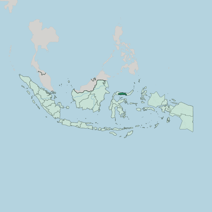
Towns & cities in Provinsi Gorontalo
Pick a town or city — each links to where to stay.
Gorontalo city is the base. The capital sits in the southeast on the Gulf of Tomini, and it is the natural launch point for the whale sharks that gather off Botubarani beach each year. Limboto lies just inland beside the shrinking lake, with the Otanaha Fortress on hills back toward the capital.
For beaches, cross to Saronde Island off the Celebes Sea coast in the north, where simple cottages sit on white sand. Divers stay east, along the Olele coast.
About Provinsi Gorontalo
Whale sharks draw most outside visitors.
What is Provinsi Gorontalo known for?
They gather off Botubarani beach on the Gulf of Tomini, where the seabed plunges fast and the giant plankton-eaters feed within a few metres of the sand. The province also answers to another name: Serambi Madinah, the Veranda of Medina. That title honours the Islamic law its pre-colonial kingdoms wrote into government and court, and it still colours daily life across Gorontalo.
Karawo, a painstaking hand embroidery of cut and drawn threads, is the craft everyone here claims.
Where is Provinsi Gorontalo?
Provinsi Gorontalo occupies the middle of the long northern arm of Sulawesi, the orchid-shaped island Europeans once called Celebes. It is a narrow province. The Celebes Sea washes its northern shore, while the Gulf of Tomini cuts in from the south, so both coasts belong to Gorontalo and the land between them is never wide. North Sulawesi adjoins it to the east, and Central Sulawesi to the west.
The capital, Gorontalo, stands in the southeast on the Tomini side, well away from the northern coast. Inland the ground climbs quickly. Coastal flats give way to forested hills and to peaks that climb past two thousand metres.
West of the capital lies Lake Limboto, a broad, shallow lagoon that gathers the water of some two dozen rivers and has been shrinking for decades. Its outflow runs the other way, draining toward the Bone and Bolango, which meet at Gorontalo city. The Gulf of Tomini itself is extraordinarily deep, its floor dropping past four thousand metres, and the equator runs straight across it.
That depth so close to shore is why whales, dolphins and other open-ocean animals turn up within sight of the beaches.
What is Provinsi Gorontalo like?
The province takes its character from the Gorontalo people, who make up almost everyone here and are overwhelmingly Muslim. Faith and custom are inseparable here. Local law rests on the principle adat bersendi sara, sara bersendi kitabullah, meaning that custom follows religious rule and religious rule follows the Quran, a formula the old sultanates left behind.
That heritage earned the province its nickname, the Veranda of Medina. The Gorontalo language, unrelated to the national Indonesian, is still heard in the markets and villages alongside it. Craft is where the culture shows off.
Karawo is the signature textile, a hand embroidery in which threads are counted, cut and drawn from the cloth before new patterns of flowers, birds and geometry are stitched into the gaps. A single piece can take weeks. Older traditions survive in speech too, in the riddles and metaphors called lumadu that adults trade as a mark of courtesy.
The province's Islamic past is written in its buildings, above all the Hunto Sultan Amai Mosque, founded near the end of the fifteenth century by the sultan whose conversion turned Gorontalo toward Islam.
What is the history of Provinsi Gorontalo?
Long before the province existed, this coast held a cluster of small kingdoms, among them Gorontalo and Limboto. Islam reached them in the fifteenth century by way of Ternate and Bone, and Sultan Amai carried it into the ruling house. Dutch power arrived late in the seventeenth century and held on for nearly three hundred years, folding the kingdoms into the Dutch East Indies.
Japanese troops took over during the war. Independence brought Gorontalo into North Sulawesi, but its Muslim majority sat awkwardly in a largely Christian province, and after Suharto fell it became a province of its own in 2000.
What is the climate of Provinsi Gorontalo?
The equator runs through Gorontalo. That keeps it hot and sticky all year, with heavy air and warm seas on both coasts. The wettest stretch runs from December to May and tops out in April, when downpours arrive on most afternoons and the rivers into Lake Limboto swell.
Drier months follow from June to September under the southeast monsoon, and August is the parched low point. Sulawesi's mountains leave it comparatively dry by Indonesian standards. Divers watch the monsoon: once the swells build after June, the coast closes down.
How do you get to Provinsi Gorontalo?
Almost everyone comes by air. Djalaluddin Airport sits about 30 kilometres west of Gorontalo city, near Tibawa, and links the province to Makassar, Jakarta and Manado on daily domestic hops. The overland alternative is the Trans-Sulawesi highway, which threads in from Manado to the east and from the Central Sulawesi side to the west.
Boats still matter here. Pelni ships and smaller ferries cross the Gulf of Tomini from ports on the far side of the bay.
Good for
Updated July 2026