Indonesia
Sulawesi Tengah, Indonesia — Towns & Travel Guide


Sulawesi Tengah, or Central Sulawesi, spans the island's mountainous waist from the Makassar Strait to the Gulf of Tomini. Palu is its capital.
About Sulawesi Tengah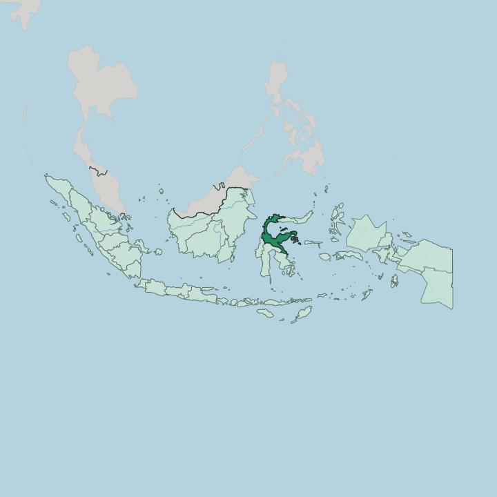
Towns & cities in Sulawesi Tengah
Pick a town or city — each links to where to stay.
Distances here are long and roads slow, so most itineraries settle in one or two bases. Palu, the capital, holds the airport and the bulk of the hotels. Everything else is smaller.
Reach the Togian Islands by boat from the port town of Ampana, on the Gulf of Tomini. For Lake Poso and the eastern approach to Lore Lindu, the lakeside town of Tentena is the usual stop, and the highland megaliths mean simple homestays up in the Bada and Napu valleys. Pick Palu to arrive and provision; move on for the water and the forest.
About Sulawesi Tengah
Three names pull travellers this far.
What is Sulawesi Tengah known for?
Lore Lindu National Park spreads its montane forest south of Palu, sheltering endemic birds and mammals found nowhere else, while ancient granite megaliths, some carved into human figures, stand scattered across its Bada and Napu valleys. Out in the Gulf of Tomini, the Togian Islands ring reefs and a saltwater lake of stingless jellyfish. Inland, Lake Poso drops to great depth between forested hills, the third-largest lake in Indonesia.
Divers, birdwatchers, and archaeology buffs each come for a different piece.
Where is Sulawesi Tengah?
Sulawesi Tengah occupies the middle of Sulawesi, the tangled, four-armed island that Europeans once called Celebes. Its shape is all coastline and mountain. To the west the land drops into the Makassar Strait, the deep channel that separates Sulawesi from Borneo; to the north lies the Celebes Sea.
The great eastern indentation is the Gulf of Tomini, one of the largest gulfs in the archipelago, with the smaller Tolo Bay biting in below it. Palu, the capital, sits in the far west at the head of a long, narrow bay, where the Palu River finishes its run down a steep valley to the Makassar Strait. A slender eastern peninsula reaches out toward the Banggai Islands, carrying the port of Luwuk near its tip.
Inland, the province climbs fast. Mountain ranges rise steeply toward the interior, Nokilalaki among the higher summits, and cloud forest cloaks the upper slopes. Lore Lindu National Park protects a broad block of that highland south of Palu, draining toward Lake Poso, which fills a deep basin in the south-central hills.
This is rugged, thinly settled country. Beyond Poso, the Trans-Sulawesi road threads valley after valley to reach the coast at Ampana, the jumping-off point for the Togian Islands scattered across the Gulf of Tomini. Little of Sulawesi Tengah is flat.
What is Sulawesi Tengah like?
No single people fills Sulawesi Tengah. The Kaili are the largest group, clustered around Palu and the Donggala and Sigi lowlands, while the Pamona live inland near Lake Poso, and dozens of smaller communities hold the highland valleys. Linguists count more than twenty living languages here, so villages a short walk apart can speak differently, and Indonesian is the shared tongue of market and school.
Bugis and Javanese settlers thicken the coastal towns. Faith splits by geography too. The coasts lean Muslim; the inland districts around Poso are heavily Christian, a division that fed bitter communal violence at the turn of the century before the Malino accords settled it.
Stone is the province's deepest signature. Hundreds of megaliths, carved cylinders, urns, and human figures like the towering Palindo, stand in the Bada, Napu, and Besoa valleys, set up by people whose names and dates are largely lost to us. Older beliefs survive in other ways.
Among the Kaili, the Balia healing ritual still calls on spirits through chant and offering, a pre-Islamic inheritance. Handloom bark cloth, ebony carving, and woven rattan carry the same long memory. Craft here is old.
What is the history of Sulawesi Tengah?
Small kingdoms once ruled these valleys and coasts, and Dutch traders reached them in the early seventeenth century, later drawing the whole interior into the colonial Indies. The province itself is young. Carved from North Sulawesi, Sulawesi Tengah became a province in its own right in 1964.
Two later events mark it. Communal fighting tore through Poso around the millennium, and on a September evening in 2018 a magnitude-7.5 earthquake off Donggala sent a tsunami into Palu Bay and liquefied whole neighbourhoods of the capital.
What is the climate of Sulawesi Tengah?
Sulawesi Tengah lies close to the equator, so it stays warm and humid the year round, with no real winter and only a loose wet-and-dry rhythm. Palu is the odd one out. Mountains ring the head of Palu's bay, and the capital sits in a rain shadow that makes it one of the driest places in Indonesia.
Rain falls on many days but rarely hard, and the parched Palu valley grows the crisp shallots fried into the region's prized bawang goreng. The hills around Lore Lindu and the Gulf of Tomini coast stay wet.
How do you get to Sulawesi Tengah?
Almost everyone flies into Palu. Mutiara SIS Al-Jufrie Airport, on the edge of the capital, links Sulawesi Tengah to Makassar, Jakarta, Surabaya, and Balikpapan, with Makassar the usual first hop from farther afield. Overland is a commitment.
The Trans-Sulawesi Highway winds for days through the mountains from the neighbouring provinces, scenic but slow. Reaching the Togian Islands means swapping the road for a boat, sailing out from the Gulf of Tomini port of Ampana, while Luwuk in the east keeps a small airport of its own.
Good for
Updated July 2026