Pakistan
Azad Jammu and Kashmir, Pakistan — Towns & Travel Guide


Azad Jammu and Kashmir is the mountainous western strip of Kashmir that Pakistan administers, threaded by the Jhelum and Neelum rivers.
About Azad Jammu and Kashmir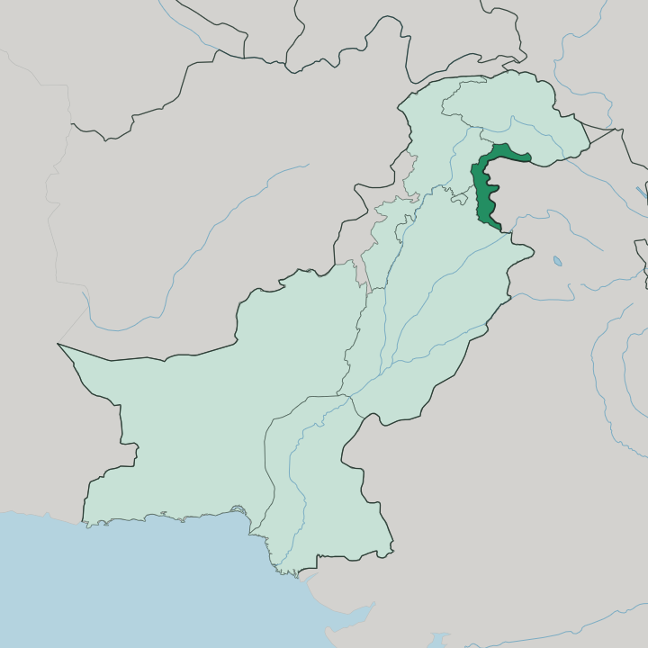
Towns & cities in Azad Jammu and Kashmir
Pick a town or city — each links to where to stay.
Muzaffarabad is the natural first base, the capital set at the meeting of the Neelum and the Jhelum, with the valley roads branching off from it into the mountains. Beyond it, choose by valley. Athmuqam and Sharda string hotels up the Neelum Valley toward the walk to Arang Kel, while Rawalakot and its Banjosa Lake anchor the pine-forested Poonch highlands to the south-west.
Mirpur, the Mangla Dam town rebuilt on British-Kashmiri remittance money, is the southern hub near the Punjab plain. Choose Muzaffarabad to reach the rivers and valleys; choose the Neelum Valley when the mountains themselves are the point.
About Azad Jammu and Kashmir
Green mountain valleys are the draw.
What is Azad Jammu and Kashmir known for?
This is Pakistan's slice of the wider Kashmir region, a curving band of forested ridges and river gorges pressed against the Line of Control. Muzaffarabad, the capital, sits where the Neelum meets the Jhelum, and it is where most trips begin. North of it the Neelum Valley climbs toward Sarwali Peak through pine forest, terraced villages, and trout streams that draw walkers up to Arang Kel and beyond.
Farther south around Mirpur the land flattens toward the Mangla Dam, whose reservoir drowned the old town and sent a generation of Mirpuris to Britain.
Where is Azad Jammu and Kashmir?
Azad Jammu and Kashmir is a long, narrow arc of mountain country forming the western edge of the disputed Kashmir region, administered by Pakistan. Its eastern boundary is not a settled border but the Line of Control, the ceasefire line that has divided Pakistani-held from Indian-held Kashmir since the fighting of 1947. Gilgit-Baltistan lies to the north, across higher ground still. To the south and west the mountains fall away toward the Pakistani provinces of Punjab and Khyber Pakhtunkhwa, where the plains begin.
Three rivers organise the whole territory. The Jhelum threads down from the north through Muzaffarabad, the Neelum joins it there after carving the long valley that bears its name, and the Poonch drains the southern hills. In the north the land belongs to the foothills of the Himalayas, and the Pir Panjal Range walls off much of the interior with a crest that runs high and snow-held for months.
Sarwali Peak, above the Neelum Valley, is the highest point of all. Everything here is either river or ridge. Down south the ground finally relents around Mirpur, where the Jhelum backs up behind the Mangla Dam into a broad reservoir before it slips out onto the Punjab plain.
It is a place defined by water cutting through rock, and the valleys are the only easy roads.
What is Azad Jammu and Kashmir like?
The culture here is mountain culture, and it changes as you move down the valleys. In the north around Muzaffarabad and the Neelum Valley, most people speak a Pahari-Pothwari tongue, with Gojri heard among the herders and Kashmiri surviving in pockets close to the Line of Control. Urdu is the official language, and English carries the schooling.
The southern districts around Mirpur, Kotli, and Bhimber feel closer to the Punjab plain than to the high peaks. That southern corner has a second home overseas. When the Mangla Dam flooded the old Mirpur in the 1960s, tens of thousands of displaced Mirpuris resettled in Britain, and the towns of the south are now bound as tightly to Bradford and Birmingham as to Muzaffarabad.
Remittance money paved their streets. Family here can mean a household split between two countries. Food leans to the Punjabi and Kashmiri table, and the working life is farming, forestry, and the trout of the Neelum.
People leave. Then they return.
What is the history of Azad Jammu and Kashmir?
Azad Jammu and Kashmir was born out of the chaos of 1947. As British India split into India and Pakistan, an uprising against the maharaja began in the Poonch hills and spread through the western districts of the old princely state. Fighting reached Mirpur that November, and by the time the guns paused the rebels held this western arc as a self-governing territory tied to Pakistan.
The name means "free Kashmir." The ceasefire that ended the first war froze the front into what became the Line of Control, and that line has shaped every year since.
What is the climate of Azad Jammu and Kashmir?
Climate here follows altitude, not season alone. The southern districts around Mirpur and Bhimber bake in summer and stay mild in winter, sharing the hot temper of the neighbouring Punjab plain. Climb north into the Neelum Valley and the pattern flips: summers turn cool and green under the Pir Panjal, and winters bring heavy snow that shuts the high roads to Kel and Taobat for months.
Rain arrives with the summer monsoon, and Muzaffarabad is among the wettest towns in Pakistan. Bring layers whatever the month.
How do you get to Azad Jammu and Kashmir?
Nearly everyone arrives overland. Islamabad is the usual arrival point by air, and from there a road climbs the Jhelum gorge into the mountains to reach Muzaffarabad in a few hours. Mirpur sits closer to the plain, an easy run up from the Punjab past the Mangla Dam.
From the capital the valley roads branch off. One follows the Neelum north toward Sharda and Kel, while another climbs south-west to Rawalakot in the Poonch hills. Winter snow can close the highest of them.
Good for
Updated July 2026