Turkey
Osmaniye, Turkey — Towns & Travel Guide


Osmaniye is a small inland province of southern Turkey, spread across the eastern edge of the Çukurova plain below the Nur Mountains.
About Osmaniye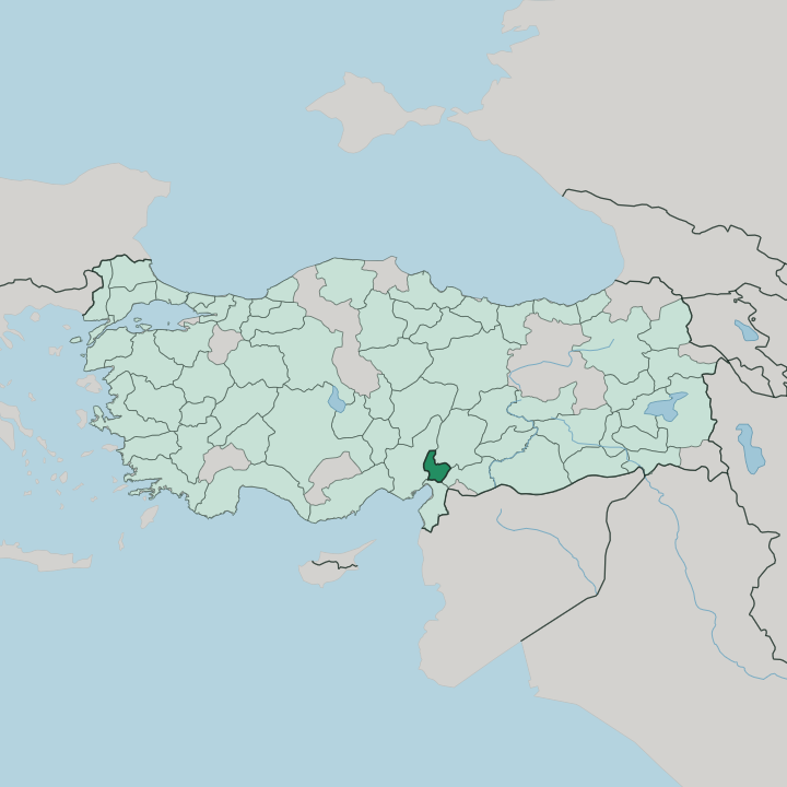


Towns & cities in Osmaniye
Pick a town or city — each links to where to stay.
Most beds cluster in Osmaniye itself, the provincial seat under the Nur Mountains where the buses and hotels gather. Osmaniye town is the obvious place to base yourself. Kadirli, to the north, sits closest to Karatepe-Aslantaş and its wooded national park, where the Neo-Hittite fortress looks down over the Ceyhan river and the Aslantaş reservoir.
Düziçi lies east in the foothills, handy for the Haruniye thermal springs. For the ruins of Kastabala, a short run north of the town brings you to the colonnaded street and its castle. Stay in Osmaniye for the links.
Move out only to sleep nearer one particular site.
About Osmaniye
What is Osmaniye known for?
Two ancient sites carry the province's name. At Karatepe-Aslantaş, in the hills of the Kadirli district, a Neo-Hittite hilltop fortress guards lion gates and a bilingual inscription that helped scholars crack the Luwian language. Kastabala adds a Roman colonnaded street below a crusader castle.
The plain between grows peanuts in bulk, and Osmaniye is Turkey's peanut center, where most of the crop is processed and traded. The city itself keeps few sights; it works best as a base for the countryside around it.
Where is Osmaniye?
Osmaniye lies in southern Turkey, at the eastern end of the Çukurova plain that the ancients knew as the Cilician plain. It is one of the country's smaller provinces. Flat farmland fills the west, where the plain runs out toward Adana, while the Nur Mountains, the old Amanos, still called the Gavur Dağları, wall off the south and east in a steep green ridge.
Between the two the land tilts from mountain to plain. Kahramanmaraş lies to the north and Gaziantep to the east, with Hatay wrapped around the south. The Mediterranean itself stops short of the border, a little beyond the province's south-western corner. The Ceyhan river is the province's spine.
It runs down from the Nurhak range far to the north and crosses Osmaniye on its way to the sea, and the Aslantaş Dam holds part of it back in a long reservoir below Kadirli. Peanut fields, citrus and cotton spread across the watered flats. Higher up, pine and oak forest climbs the Nur slopes toward the high Taurus that shuts off the plateau beyond.
Karatepe-Aslantaş guards the river gorge; Kastabala keeps watch over a smaller plain nearby. The whole province is compact enough to cross in a day.
What is Osmaniye like?
Osmaniye is a young town in an old land. The town itself was settled only in the nineteenth century, when the Ottoman state brought the Ulaşlı Turkmen down from the Nur Mountains and fixed them to the plain. Cerit, Tecirli and Ulaşlı, the tribal names still label neighbourhoods and villages across the plain.
That nomad past still shows. Yörük roots still run through the villages, in the halay lines danced at weddings, the kilims on the looms, and a plain and meat-heavy Cilician kitchen. Around Osmaniye, Turkish is what you hear day to day.
Peanuts are the local badge of pride. The crop shapes the calendar and even the sweets, and the town throws a peanut festival when the harvest comes in. Kadirli, the province's second town, gave Turkish letters one of their giants: the novelist Yaşar Kemal grew up in its villages, and his Çukurova stands in for this very plain.
The everyday table leans on lamb, bulgur pilaf and the fiery pepper paste of the Cilician plain. Grand monuments and crowds are not the point here. The character is rural and close to the soil, lived in orchards, wheat fields and mountain pasture rather than behind glass.
What is the history of Osmaniye?
The plain's story is far older than the town. In the Iron Age a Neo-Hittite kingdom called Que ruled the Adana plain and guarded its northern frontier with the fortress at Karatepe, and Rome later raised temples at Kastabala on the Ceyhan. The town of Osmaniye came late.
It was founded in 1865, when Derviş Paşa's Fırka-i İslahiye settled the Ulaşlı Turkmen at the foot of the Nur Mountains. Known as Cebel-i Bereket under the Ottomans, it took its present name after the republic, and in 1996 it was cut from Adana to stand as a province of its own.
What is the climate of Osmaniye?
Osmaniye keeps a hot-summer Mediterranean climate. Summers on the plain run long, dry and fierce, with the heat pressing up against the Nur Mountains through high summer. The rain saves itself for winter.
From late autumn the clouds pile against the range and empty over the foothills, so the growing season leans on that cool, wet half of the year. Snow settles on the higher Nur and Taurus slopes while the citrus below barely feels a frost.
How do you get to Osmaniye?
No airport serves Osmaniye directly. Most travellers fly into Adana, an hour or so west along the plain, and come on by road or rail. The main line east from Adana toward Gaziantep runs through the province, and Toprakkale has been a rail junction since the old Baghdad Railway was laid.
The motorway that crosses southern Turkey passes the same way. Frequent buses drop into the centre, and from Osmaniye the district towns are a short hop by minibus.
Good for
Updated July 2026