Turkey
Sakarya, Turkey — Towns & Travel Guide


Sakarya is a green province in northwestern Turkey where Lake Sapanca and the Sakarya River draw weekend visitors east from Istanbul.
About Sakarya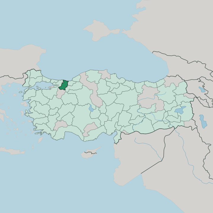


Towns & cities in Sakarya
Pick a town or city — each links to where to stay.
Most trips base on the water. Sapanca, on the lake of the same name, has the widest spread of bungalows and thermal hotels, and it is the easy pick for a first visit close to Istanbul. For the coast, Karasu offers a wide Black Sea beach at the mouth of the Sakarya River.
Adapazarı, the provincial hub out on the plain, keeps the transport links, the produce market, and the best köfte houses in the province. Taraklı, deep in the southern hills, trades beaches and nightlife for restored Ottoman streets. Pick the lake first.
About Sakarya
Water and greenery define it.
What is Sakarya known for?
Lake Sapanca, a freshwater lake ringed by wooded ridges just southwest of Adapazarı, is the best-known draw, close enough to Istanbul for a weekend of boats, thermal springs, and lakeside walking. North of the plain the Black Sea coast opens into the long sand beaches of Karasu, where the Sakarya River finishes its run to the sea. Inland, the restored Ottoman timber houses of Taraklı climb a quiet hillside.
Food matters here too, and Adapazarı gives its name to Islama köfte, grilled meatballs served over broth-dipped bread.
Where is Sakarya?
Sakarya lies in northwestern Turkey. It fills the eastern corner of the Marmara Region, about 160 km east of Istanbul on the main road and rail line running from the city into Anatolia. Kocaeli borders it to the west, Bilecik to the south, the wooded hills of Bolu to the southeast, Düzce to the east, and the Black Sea to the north. At its centre spreads the Adapazarı plain, one of the most fertile lowlands in the country, built up over ages by the Sakarya River.
The river ranks third longest in Turkey. It rises far inland on the Anatolian plateau, loops across the province, and breaks into a web of channels and estuaries before reaching the Black Sea near Karasu. Southwest of Adapazarı, Lake Sapanca fills a long trench between wooded ridges, its outflow slipping out the eastern end toward the Sakarya River and the Black Sea.
Beyond the plain the land climbs fast. Low mountains under beech and chestnut forest ring the lowland on almost every side, cut by river valleys and topped with plateaus and upland pastures grazed through the summer. The northern coast is short but real, a strip of dunes and long sand beaches broken by the river mouths.
It is a compact province. The whole width, from the lake to the Black Sea, can be crossed in little more than an hour, thermal resorts giving way to orchard country and then to open beach.
What is Sakarya like?
Sakarya is farm country first, and the black soil of the Adapazarı plain grows maize, sugar beet, potatoes, and the hazelnut groves that spread east toward the Black Sea provinces. The land is unusually generous. Its market gardens are known across Turkey for outsized produce, and Adapazarı still means a busy produce market to much of the country.
The people are as mixed as the crops, and the plain took in waves of muhacir settlers, Circassians and other Caucasian communities alongside Balkan Muslims, who arrived through the late Ottoman decades and gave the province a patchwork of villages and traditions. That mix shows up at the table. Adapazarı gives its name to Islama köfte, small grilled meatballs laid over bread first dipped in meat broth and brushed with a peppery sauce, a dish carried in from the Balkans.
Circassian weddings and their dances still mark the calendar in the immigrant villages. Leisure runs to the outdoors. On weekends the lakeshore at Sapanca fills with families from Adapazarı and Istanbul alike, out for fish lunches, tea gardens, and slow walks under the plane trees, while the university crowd at Serdivan keeps Adapazarı younger than its farm-town roots suggest.
What is the history of Sakarya?
The valley is old ground. In antiquity this was the country of Bithynia, and the Sakarya River carried the classical name Sangarius, spanned near Adapazarı by the stone Sangarius Bridge that the emperor Justinian raised in the sixth century. Under the Ottomans the plain grew up around a market, and the name Adapazarı means the island market.
The modern province was carved out in 1954. Then came the disaster of 17 August 1999, when the İzmit earthquake struck the plain and flattened much of Adapazarı, after which the city rebuilt its centre on firmer ground.
What is the climate of Sakarya?
Sakarya stays green because it stays wet. The province sits between the Black Sea and the Sea of Marmara, catching damp maritime air, so rain falls through every season rather than drying out in summer as it does further inland. The coast in the north is mild and humid, softened by the sea.
Southward, sheltered by the hills, the summers turn warmer and more humid, closer to a subtropical feel around Lake Sapanca. Winters are cool and grey. Snow settles on the wooded hills and the upland pastures each winter, though the lowland plain sees it more briefly.
How do you get to Sakarya?
Sakarya sits on the main line between Istanbul and Ankara, so most visitors simply peel off the highway or the railway that already runs the length of the province. The road is the usual way. The trans-European motorway from Istanbul crosses the province, putting Adapazarı and Lake Sapanca within a two-hour drive of the city.
Trains help too, and the fast Ankara service stops at Arifiye on the edge of Adapazarı, with slower regional trains running in from Istanbul. There is no airport of its own. Air travellers land at one of the two Istanbul airports and come the rest of the way by car, bus, or train.
Good for
Updated July 2026