Indonesia
Provinsi Jambi, Indonesia — Towns & Travel Guide


Jambi is a province of central Sumatra, stretched from the Batang Hari river to Mount Kerinci, the highest volcano in Indonesia.
About Provinsi Jambi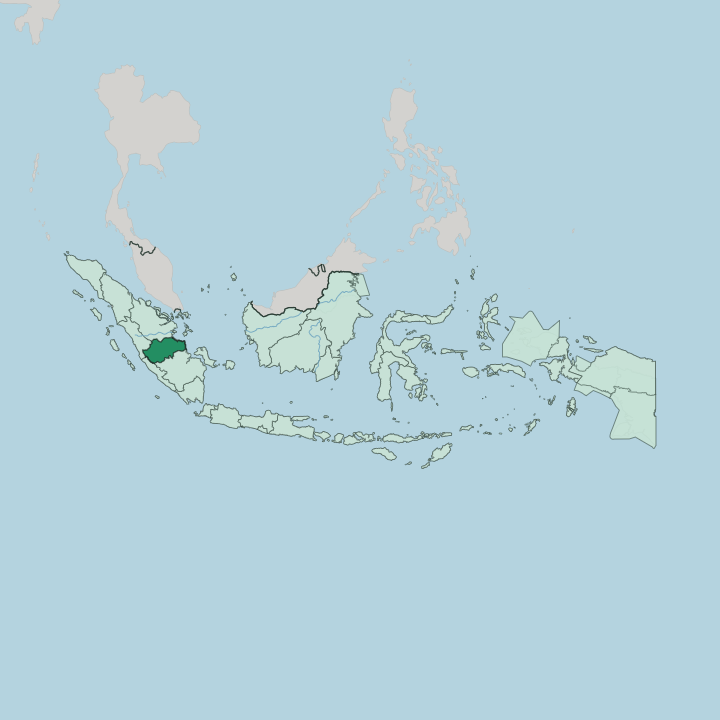
Towns & cities in Provinsi Jambi
Pick a town or city — each links to where to stay.
Jambi city is the obvious first base, set on both banks of the Batang Hari beside the Angso Duo market and the Gentala Arasy footbridge. From there the temple compounds of Muaro Jambi lie a short drive downriver, best seen as a day trip rather than an overnight. The other pole is the western highlands.
Kersik Tuo, a cluster of guesthouses below the Kayu Aro tea estate, is where climbers stage the ascent of Mount Kerinci; the valley town of Sungai Penuh sits deeper in, near Lake Kerinci and the trails of Kerinci Seblat National Park. Pick the city for rivers and ruins, the highlands for volcanoes and forest.
About Provinsi Jambi
What is Provinsi Jambi known for?
Two things define Jambi: an ancient river and a young volcano. The Batang Hari, the longest river on Sumatra, threads the province from the Barisan Mountains down to the swampy east coast, and its estuarine plain once carried the Buddhist temple city of Muaro Jambi. Inland, the land climbs west to Mount Kerinci, the highest volcano in Indonesia, ringed by the tea gardens of Kayu Aro.
Kerinci Seblat National Park guards the tigers of the western highlands. Rivers and rainforest pull visitors, not beaches.
Where is Provinsi Jambi?
Jambi occupies the middle of Sumatra's eastern flank, one of ten provinces on the island. Its shape is a cross-section of Sumatra itself. The land tilts from the volcanic spine of the Barisan Mountains in the west down through hill country and rubber plains to a low, swampy coast facing the Berhala Strait in the east. Riau borders it to the north, West Sumatra to the west, Bengkulu to the south-west, and South Sumatra to the south.
The Batang Hari orders everything. Sumatra's longest river rises in the western highlands and runs the width of the province, past the capital at Jambi and on to the eastern shore, navigable by coastal boats far upstream. In the far west, above the town of Sungai Penuh, the land folds into the Kerinci valley, a highland trough held between ranges.
Mount Kerinci rises there, the highest volcano in Indonesia, its cone often wrapped in cloud above the Kayu Aro tea gardens. Much of that western upland falls inside Kerinci Seblat National Park, the largest national park on Sumatra. Lowland peat swamp and mangrove fringe the seaward edge.
It is a province best understood as a river's journey, mountain to sea.
What is Provinsi Jambi like?
Jambi is a Malay province at heart, Muslim and river-oriented, its older courts remembered in the batik patterns and songket weaving of the capital. That Malay world is not the whole story. In the western mountains around Sungai Penuh live the Kerinci people, whose highland valley kept its own language and an old syllabic script, surat incung, once incised on bamboo and buffalo horn.
Down in the lowland forests move the Orang Rimba, also called Anak Dalam or Kubu, a Malay-speaking people who traditionally shift camp between swidden plots and the hunt for wild yams. Islam frames daily life across the plains. Yet the province wears a much older skin beneath it.
The red-brick sanctuaries of Muaro Jambi are Buddhist, raised when this stretch of the Batang Hari was a monastic centre of the Melayu kingdom and Srivijaya. Food leans to freshwater fish and the sour-spiced tempoyak made from fermented durian. Adat, the Malay code of custom, still governs marriage and land in many villages.
History here is layered, not linear.
What is the history of Provinsi Jambi?
Chinese records name a kingdom called Melayu on the Batang Hari as early as the 7th century, and the pilgrim monk Yijing noted it on his sea voyage in 671. From that river base grew the temple city of Muaro Jambi, a Buddhist learning centre bound to Srivijaya. Melayu outlasted its overlord and dominated Sumatran trade until Javanese armies of Singhasari struck in 1275.
A Muslim sultanate later ruled Jambi before the Dutch absorbed it. The modern province dates to 1957.
What is the climate of Provinsi Jambi?
Jambi runs hot and wet on a tropical, equatorial rhythm. The lowlands along the Batang Hari stay humid all year, with the heaviest rains falling roughly between October and March. There is no cold season on the plains, only wetter and drier months.
The mountains rewrite the rule. Up in the Kerinci valley the air turns cool, and nights on the upper slopes of Mount Kerinci can be genuinely cold. In the drier stretch, smoke haze from peatland and plantation fires sometimes settles over the province.
How do you get to Provinsi Jambi?
Sultan Thaha Airport, on the edge of the capital, is the province's main airport, with domestic flights from Jakarta and other Sumatran cities. Overland, the Trans-Sumatran Highway ties Jambi to Padang, Palembang and points beyond. Buses grind those routes.
The Kerinci highlands are the hard part to reach. Sungai Penuh and Mount Kerinci sit a full day's drive west of the capital, so many climbers approach the volcano from Padang instead. Long before roads or runways, the Batang Hari was the main road, and boats worked their way up from the coast.
Good for
Updated July 2026