Indonesia
Propinsi Bengkulu, Indonesia — Towns & Travel Guide


Bengkulu lines Sumatra's southwest coast on the Indian Ocean, the old British pepper port of Bencoolen and land of the giant Rafflesia flower.
About Propinsi Bengkulu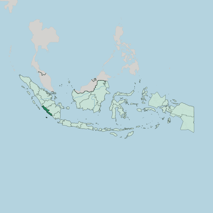
Towns & cities in Propinsi Bengkulu
Pick a town or city — each links to where to stay.
Most trips start in Bengkulu. The seafront capital keeps Fort Marlborough and the long grey sand of Pantai Panjang within a few minutes of one another, an easy first base on the Indian Ocean. Inland and uphill, Curup opens the cooler Rejang highlands under the Bukit Kaba crater, coffee country reached by road from the coast.
Enggano lies far offshore, a long boat ride out. Start in the capital first; climb to Curup for the volcano and the coffee, or sail to Enggano for the remote outer edge of the province.
About Propinsi Bengkulu
What is Propinsi Bengkulu known for?
The province was the British foothold on Sumatra, a pepper port they called Bencoolen. Fort Marlborough still stands over the sea in the capital, Bengkulu, built by the East India Company after 1714. Stamford Raffles governed the settlement in the years he founded Singapore, and it was here that the giant Rafflesia arnoldii, the largest single flower on earth, was first described for science and later took his name.
Sukarno spent his exile years in the town before independence. Coffee and the flower are its emblems.
Where is Propinsi Bengkulu?
Bengkulu is a long strip of Sumatra's southwest coast, facing the open Indian Ocean the whole way. The shore stretches roughly 525 kilometres, from Mukomuko in the north to Kaur in the south. Behind it the land climbs fast.
The Barisan Mountains run the length of the province a little inland, a volcanic spine that separates the coast from the interior, and Mount Kaba still smokes above the town of Curup on that ridge. Three bands make up the terrain: a lowland shelf along the sea, a belt of hills in the middle, and the mountains along the eastern rim. West Sumatra lies to the north. Jambi and South Sumatra sit over the mountains to the east, and Lampung closes the province off to the south, while the Indian Ocean fills the entire western side. Enggano and a scatter of smaller islands lie well out in that ocean, part of the province though a long way from its coast.
The whole shore sits above the Sunda megathrust, where the sea floor grinds under Sumatra, so earthquakes and tsunami warnings are a fact of life here. It is a coast that shakes.
What is Propinsi Bengkulu like?
The Rejang are the largest of the province's peoples, farming the uplands around Curup, and Javanese families brought by transmigration make up much of the rest. Serawai, Lembak and Pekal communities hold the southern and coastal districts, and the Enggano keep their own language on their island out in the Indian Ocean. Rejang and Bengkulu Malay are spoken at home; Indonesian ties it all together.
Islam is the common faith. Coffee threads through daily life, robusta grown on the volcanic slopes and drunk strong and black. The signature event is Tabot.
Each Muharram the streets of Bengkulu fill with tall gilded funeral towers that mourn the death of Husain at Karbala, a rite carried here by Indian Muslim soldiers who came with the British to build Fort Marlborough and stayed. The towers are paraded for days and then cast away into the sea. The giant Rafflesia is the other emblem, the bloom that gave the province its nickname and appears on everything from signs to souvenirs.
Old Bengkulu wears its layers plainly: Malay, British, Indian and Javanese, all on one stretch of coast.
What is the history of Propinsi Bengkulu?
The British East India Company planted a pepper post here in 1685 and called it Bencoolen. It became their main hold on Sumatra. Fort Marlborough went up around 1714 to replace an abandoned earlier fort, and Stamford Raffles governed the settlement before Britain traded it to the Dutch in 1824 for Malacca.
Long after, the Dutch exiled Sukarno to the town from 1938, and he met Fatmawati here before the war. Bengkulu became a province of Indonesia in its own right in 1968.
What is the climate of Propinsi Bengkulu?
Bengkulu sits deep in the tropics, hot and wet the year round. In Bengkulu the rain never lets up. The Indian Ocean feeds heavy monsoon downpours that pile up against the Barisan Mountains, and the wettest months fall between the end of one year and the start of the next, when storms roll in off the sea.
The coast around Bengkulu stays warm and sticky. Up in the Rejang highlands near Curup the air turns cooler and the mornings mist over.
How do you get to Propinsi Bengkulu?
For most, Bengkulu means a flight. Fatmawati Soekarno Airport, on the edge of the capital, links Bengkulu to Jakarta and the other Sumatran hubs, and it is named for the woman who sewed Indonesia's first flag. By land, roads climb over the Barisan Mountains from Palembang and Lampung to the east, a long haul through the hills with no railway to shorten it.
Enggano is the hard part: a ferry across open ocean, or a light plane, is the only way out to the island.
Good for
Updated July 2026