Indonesia
Provinsi Kalimantan Timur, Indonesia — Towns & Travel Guide


Provinsi Kalimantan Timur lines the east coast of Borneo, drained by the Mahakam River and the site of Indonesia's new capital, Nusantara.
About Provinsi Kalimantan Timur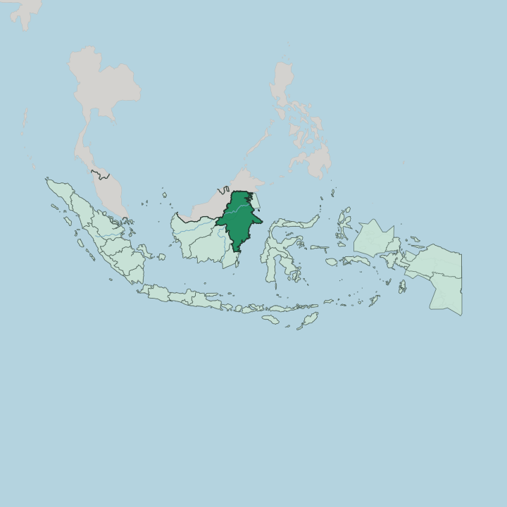
Towns & cities in Provinsi Kalimantan Timur
Pick a town or city — each links to where to stay.
Most trips start in Balikpapan, the coastal refinery city where the region's flights land and the new road runs north to Nusantara. Samarinda, the capital, sits a little upriver on the Mahakam and makes the natural base for boats into the Kutai interior. Two very different escapes lie beyond.
Off the Berau coast in the northeast, the Derawan Islands draw divers to their turtles and manta rays. The old Kutai palace stands upriver at Tenggarong. Fly in through Balikpapan; base on the Mahakam at Samarinda or Tenggarong for the river, and cross to the Derawan Islands for the reef.
About Provinsi Kalimantan Timur
What is Provinsi Kalimantan Timur known for?
Two things define Provinsi Kalimantan Timur: oil and the forest. Balikpapan grew up around refineries fed by the offshore fields of the Makassar Strait, while inland the province ships coal and timber down the Mahakam River to the coast. Samarinda sits upstream, the busiest city on Borneo.
Beyond the ports, the draw is wild. Orangutans still range through Kutai National Park, and divers come for the turtles and manta rays of the Derawan Islands. And near the coast, Indonesia is carving its new capital, Nusantara, out of the tree line.
Where is Provinsi Kalimantan Timur?
Provinsi Kalimantan Timur occupies the eastern flank of Borneo, the third-largest island on Earth, facing the Makassar Strait that divides Borneo from Sulawesi. The province is vast and thinly settled. Its spine is the Mahakam River, the longest in the province, which gathers in the interior highlands near the border with Sarawak and runs east for hundreds of kilometres before spilling into the strait through a wide delta below Samarinda.
Midway along its course the river slows into a maze of shallow lakes and swamp forest, the Mahakam Lakes. Freshwater dolphins live there. Coal barges, passenger boats and log rafts all use the same brown water.
On land the province meets North Kalimantan to the north, Central Kalimantan and West Kalimantan to the west, and South Kalimantan to the south, while the far interior touches the Malaysian state of Sarawak. The eastern edge is all coast. The Mangkalihat Peninsula pushes out between the Makassar Strait and the Celebes Sea, and off the northeast shore the coral of the Derawan Islands breaks the surface.
Inland the land climbs from mangrove and lowland rainforest, some of it protected in Kutai National Park, toward rugged hills in the west. Between Balikpapan and Samarinda, on the low ground behind the coast, Indonesia is building Nusantara, its new national capital.
What is Provinsi Kalimantan Timur like?
No single people fills Provinsi Kalimantan Timur. The interior belongs to the Dayak, the indigenous groups of Borneo, whose longhouses and hornbill carvings still stand along the upper rivers. Along the Mahakam live the Kutai, a Muslim people descended from Dayak stock who gave the old kingdoms their name.
The coast tells a different story. Bugis sailors crossed the Makassar Strait from Sulawesi to trade and settle, Banjar merchants came down from the south, and waves of Javanese arrived through transmigration to work the land and the oilfields. Their common tongue is Indonesian, though Banjar serves as the everyday lingua franca of the streets and markets.
That inheritance shows most clearly at Tenggarong. Once a year the town stages the Erau festival, a rite carried down from the Kutai Kartanegara sultanate in which Dayak dancers, river processions and a ceremonial soaking of the crowd fill the streets for days. The Mulawarman Museum, set in the sultans' former palace beside the Mahakam, keeps the crowns, thrones and Chinese ceramics of that court.
Music, beadwork and woodcarving carry the older traditions. Away from the festival, life runs on the river and the market, and the food leans on freshwater fish, rice and the fierce local sambal.
What is the history of Provinsi Kalimantan Timur?
East Kalimantan holds the oldest written history in Indonesia. Along the Mahakam near Muara Kaman rose Kutai Martadipura, a Hindu kingdom of the fourth century whose seven inscribed stone pillars name King Mulawarman and record his gifts of cattle to the brahmins. A later Muslim dynasty, the Kutai Kartanegara sultanate, absorbed that old realm and ruled from Tenggarong.
The Dutch broke the sultan's power in 1844. Indonesia drew the modern province in 1957.
What is the climate of Provinsi Kalimantan Timur?
The climate is equatorial: hot, wet and close all year. There is no cold season here. Rain falls in every month, but the heaviest downpours come between November and April, when the Mahakam swells and low ground floods.
The drier stretch runs from May to October. In the dry months smoke from peat and forest fires can haze the coast around Balikpapan and Samarinda. The Makassar Strait keeps nights warm and the air heavy.
How do you get to Provinsi Kalimantan Timur?
Nearly every visitor flies into Balikpapan. Its Sepinggan airport is the largest in the region and the main approach to the new capital at Nusantara, reached by a toll road up the coast. Samarinda has its own airport for domestic hops.
From the coast, longboats and passenger craft still carry people far up the Mahakam into the interior. Ferries cross the Makassar Strait from Sulawesi. Roads are slower going.
The Trans-Kalimantan highway threads through forest and coal country to link the towns.
Good for
Updated July 2026