Indonesia
North Kalimantan, Indonesia — Towns & Travel Guide


North Kalimantan, carved from East Kalimantan in 2012, sits on the northern tip of Borneo where the Kayan River empties into the Celebes Sea.
About North Kalimantan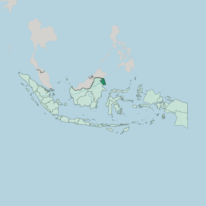
Towns & cities in North Kalimantan
Pick a town or city — each links to where to stay.
Tarakan holds most of the province's hotels and is the obvious first base, with the airport, the ferry piers and the oil-town grid all on one island. Start there. Tanjung Selor, across the Kayan delta, is the quieter government seat and the launch point for river trips upstream.
Nunukan suits anyone crossing to or from Tawau in Sabah by ferry. For the interior, meaning Malinau and the Krayan highlands, rooms thin out fast, and reaching them takes a light aircraft or days on the river.
About North Kalimantan
What is North Kalimantan known for?
North Kalimantan is the youngest of Indonesia's Kalimantan provinces, carved from East Kalimantan in 2012. Two cities anchor it. Tarakan is an oil island off the coast and the largest settlement, while Tanjung Selor sits inland on the Kayan River as the provincial capital.
Behind them the land climbs into the Kayan Mentarang National Park, one of the largest protected rainforests in Southeast Asia and part of the Heart of Borneo. The northern and western edges press against the Malaysian states of Sabah and Sarawak.
Where is North Kalimantan?
North Kalimantan is the northernmost province of Indonesian Borneo, and every land border it has is a frontier. Malaysia lies along two sides. The state of Sabah runs across the north and Sarawak along the west, while East Kalimantan closes off the south and the Celebes Sea washes the entire eastern coast. Inland the ground rises hard.
The Iran Mountains follow the Sarawak border in an unbroken ridge, climbing toward the cloud forests of Kayan Mentarang National Park and the Krayan highlands beyond. Down from that watershed run the province's rivers. The Kayan is the longest, gathering in the Apo Kayan interior and spilling through a wide delta into the Celebes Sea just below Tanjung Selor; the Sesayap, Sembakung and Sebuku follow their own courses east to the same sea, braiding into estuaries at the coast.
Twelve rapids block the Kayan above the delta, sealing the highland Apokayan off from boats coming upriver. The coast itself is a scatter of islands. Tarakan and Bunyu sit just offshore, oil under both, while further north Nunukan faces Malaysia and Sebatik Island is cut in two, its southern half Indonesian and its northern half part of Sabah.
Reefs and mangrove fringe most of these shores. It is a province defined by that meeting of mountain, river and sea.
What is North Kalimantan like?
Two worlds share the province. The coast is Malay and Muslim, its towns grown from the old Sultanate of Bulungan and thickened over generations by Bugis and Javanese traders who came for the sea and the oil. The Tidung, a Dayak people of the tidal rivers, gave their name to Tana Tidung and still fish the estuaries around Tarakan.
Go upstream and the culture changes entirely. The interior belongs to the highland Dayak: the Kenyah and Kayan of the Apo Kayan, the Lun Bawang and Lundayeh of the Krayan plateau, the nomadic Punan of the deep forest. Many still live in longhouses.
In the villages ringed by Kayan Mentarang National Park, communities farm hill rice, hunt, and boil a prized mineral salt from mountain springs, a craft found in few other places on Borneo. The Krayan highlands are known for their Adan rice and that salt, both carried out by small plane. Faith splits along the same line the geography draws, with Islam on the coast and Christianity braided with older animist belief in the hills.
Because the frontier is porous, highland families often have kin across the ridge in Sarawak and Sabah. Indonesian ties it all together, spoken over a floor of Tidung, Kenyah and other Dayak tongues.
What is the history of North Kalimantan?
The coast was long ruled from Bulungan, a sultanate founded around 1731 by Kayan who came down from the Apo Kayan highlands and later took up Islam. Then came oil. Tarakan's wells made the island a prize, and Japan stormed it in January 1942 in one of the first battles of the Pacific war in the Indies; Australian troops fought their way back in 1945.
Afterward the region sat as a far corner of East Kalimantan. It became a province in its own right only in 2012.
What is the climate of North Kalimantan?
North Kalimantan sits in the wet tropics, and the heat barely moves through the year. Rain is the real variable. The province has a rainforest climate with no true dry season, though the downpours thicken toward the end of the year, heaviest through November and December.
Warm, saturated air hangs over the coast at Tarakan and Nunukan, where afternoons often break into thunderstorms rolling in off the Celebes Sea. Up in the Krayan highlands the air turns cooler and mistier, wrapping the peaks along the Sarawak border in cloud. Mornings there can feel almost cold.
How do you get to North Kalimantan?
Nearly everyone arrives through Tarakan. Juwata International Airport sits inside the island city and takes the domestic flights from Balikpapan, Makassar, Jakarta and beyond, plus a short international hop across to Tawau in Sabah. From the airport, speedboats fan out along the coast and up the Kayan to Tanjung Selor, Nunukan and the smaller river towns.
The land border with Malaysia can also be crossed at Nunukan by ferry. Reaching the far interior is harder. The Krayan highlands have no road at all, so travellers fly in on small pioneer aircraft or spend days working upriver by longboat.
Good for
Updated July 2026