Israel
Judea and Samaria Area, Israel — Towns & Travel Guide


Towns & cities in Judea and Samaria Area
Pick a town or city — each links to where to stay.
Ramallah is the practical base, an easy hop north of Jerusalem with the widest choice of hotels and the region's liveliest evenings. Bethlehem suits pilgrims. It sits minutes from the Church of the Nativity and draws visitors on the road south from Jerusalem.
Down in the Jordan Valley, Jericho trades the hill air for warmth and palm groves beside the Dead Sea, a base for the desert monasteries and the ancient mound of Tell es-Sultan. Nablus, tucked between Mount Ebal and Mount Gerizim, rewards travellers who want the old markets, the soap workshops and the kunafeh without the crowds. Choose Ramallah for a first trip; choose Jericho or Nablus when you want the valley heat or the deeper Samaria hills.
About Judea and Samaria Area
What is Judea and Samaria Area known for?
This is the name Israel gives to the West Bank, the limestone highlands west of the Jordan River. The draw is old. Jericho, down in the Jordan Valley near the Dead Sea, counts among the oldest inhabited places on Earth.
Bethlehem holds the Church of the Nativity, Hebron the Tomb of the Patriarchs, and Nablus the winding lanes of its Ottoman old city between Mount Ebal and Mount Gerizim. Ramallah, just north of Jerusalem, is where the Palestinian Authority runs its affairs and where the region's restaurants and galleries cluster.
Where is Judea and Samaria Area?
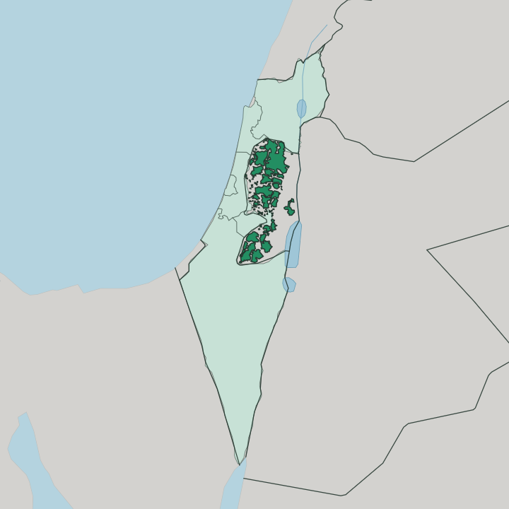
The region is the mountainous spine of the West Bank, west of the Jordan River and its rift. Israel's coastal plain lies to the west, and the land wraps around Jerusalem on three sides. Its heart is a long limestone ridge of the central highlands, cut by steep wadis into hilltop towns and terraced olive slopes.
The northern half is historic Samaria, gathered around Nablus and the twin summits of Mount Ebal and Mount Gerizim. The southern half is Judea, the ridge that carries Ramallah, Bethlehem and Hebron toward the edge of the Negev. Away from the crest the land changes fast.
The ridge climbs above eight hundred metres near Ramallah, then falls sharply east into the deep trench of the Jordan Valley, where Jericho sits well below sea level on the floor of the Jordan Rift. That descent, from cool hill towns to the warm valley in the space of an hour's drive, is the defining shape of the region. The Dead Sea, the lowest exposed land on the planet, closes the eastern edge.
West of the watershed the slopes drain gently toward the Mediterranean Sea; east of it they plunge toward the river. Little of this ground is flat.
What is Judea and Samaria Area like?
Daily life here is Palestinian, Arabic-speaking, and rooted in the olive terraces that climb every hillside. The land itself is scripture. Judea and Samaria carry the geography of the Hebrew Bible, and three faiths still reach for the same hills.
Bethlehem venerates the birthplace of Jesus at the Church of the Nativity; Hebron honours Abraham at the Ibrahimi Mosque above the Tomb of the Patriarchs; and on Mount Gerizim, above Nablus, the small Samaritan community keeps rites older than either. Food and craft carry the character as plainly as the shrines do. Nablus is famous across the region for kunafeh, the warm cheese pastry soaked in syrup, and for the olive-oil soap once shipped from its old-city workshops.
Ramallah pulls the other way, toward a modern scene of restaurants, bookshops and music that has made it the cultural centre of the Palestinian Authority. Markets stay central to town life. In the covered souqs of Nablus and Hebron the trade runs to spices, textiles, and the hand-blown glass and painted ceramics that Hebron has made for centuries.
The olive harvest each autumn remains the year's great communal work.
What is the history of Judea and Samaria Area?
Few places hold a deeper human record. Jericho was already a walled settlement thousands of years before the pyramids, one of the earliest towns anywhere. In antiquity the ridge held two neighbouring kingdoms, Judah in the south around Jerusalem and Israel in the north around Samaria, whose names still label the two halves of the region.
Rome, Byzantium and successive Muslim and Crusader rulers all left their mark on the same hills. The modern boundary is far younger. Israel took the West Bank from Jordan in 1967, and applies to it the administrative name Judea and Samaria Area, while the Palestinian Authority governs its main Palestinian towns.
What is the climate of Judea and Samaria Area?
Elevation is what dictates the climate across the Judea and Samaria Area. The highland towns of Ramallah, Nablus and Hebron have a Mediterranean climate, with hot dry summers and cool wet winters that bring the year's rain between October and April, and the odd snowfall on the highest ridges. Drop east into the Jordan Valley and the picture flips entirely: Jericho and the Dead Sea shore lie in the rain shadow, hot for much of the year and nearly rainless, so the valley draws winter visitors when the hills turn cold and grey.
Jericho stays hot and dry. West-facing slopes catch more rain than the arid east.
How do you get to Judea and Samaria Area?
Most travellers arrive through Israel. Ben Gurion Airport near Tel Aviv is the main gateway, and from there it is a short drive east to Ramallah or Bethlehem through the checkpoints ringing Jerusalem. The other route comes from the east, crossing the Jordan River from Jordan over the Allenby Bridge near Jericho, the only land crossing between the West Bank and its eastern neighbour.
Once inside, the towns are close together. Shared taxis and buses link Ramallah, Nablus, Hebron and Jericho, and most of the region's sites lie within an hour or two of Jerusalem by road.
Updated July 2026