Kenya
Kiambu, Kenya — Towns & Travel Guide


Kiambu is the highland county wrapped around Nairobi's northern edge, Kikuyu heartland of coffee estates, tea ridges and the Aberdare foothills.
About Kiambu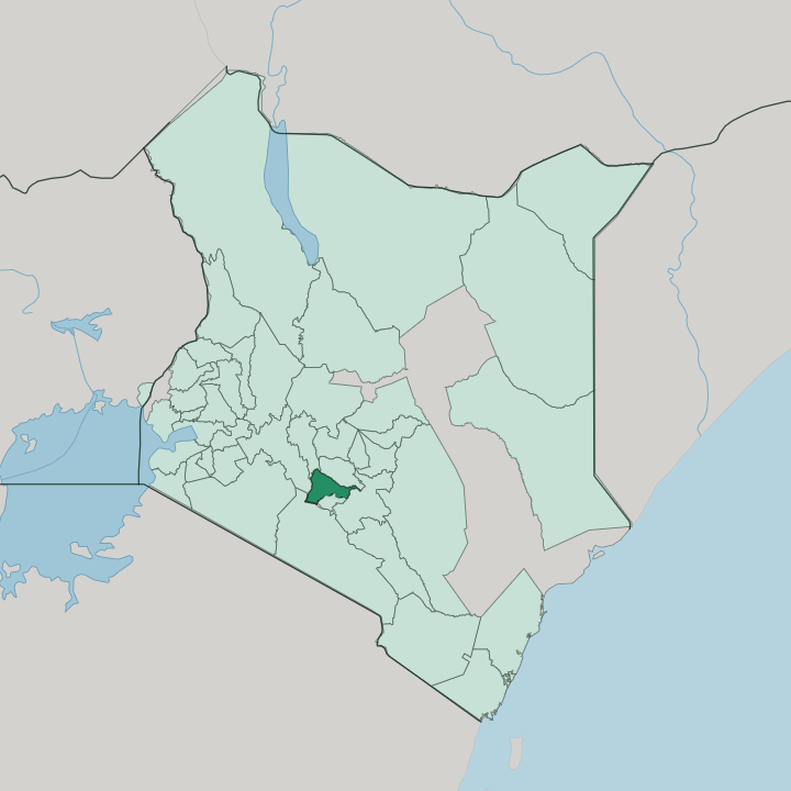


Towns & cities in Kiambu
Pick a town or city — each links to where to stay.
Kiambu rings Nairobi's north, so most beds cluster along the Thika Superhighway and in the towns strung beside it. Thika is the practical base. It puts Fourteen Falls, Ol Donyo Sabuk and the old Blue Post Hotel between the Chania and Thika falls within a short drive.
Limuru sits higher and cooler on the Aberdare escarpment, tea estates and golf greens rolling away from town. Ruiru and Kikuyu suit travellers who want Nairobi at arm's length. Pick Thika for the falls, Limuru for the highlands.
About Kiambu
What is Kiambu known for?
Kiambu is coffee-and-tea country wrapping Nairobi's northern flank, the historic heartland of the Kikuyu people. Thika anchors its industry. The town sits where the Chania and Thika rivers meet, ringed by factories that earned it the nickname Birmingham of Kenya.
Nearby, the Athi River drops over Fourteen Falls below the buffalo-backed hill of Ol Donyo Sabuk. Gatundu, further north, was the birthplace of Jomo Kenyatta, independent Kenya's first president. Green ridges and estates fill the rest.
Where is Kiambu?
Kiambu spreads across the central highlands directly north of Nairobi, in the country's old Central Province below the Mount Kenya region. The capital city presses against its southern boundary. Nairobi and Kajiado county lie to the south, Machakos to the east, Murang'a to the north and north-east, Nyandarua to the north-west, and Nakuru over the western edge.
Kiambu slopes without pause. It climbs from the warm valleys around Thika, near where the Chania and Thika rivers run, up to the cold ridges of Limuru and Lari where the Aberdare escarpment breaks against the sky. That escarpment is the county's roof and its water tower.
From the eastern slopes of the Aberdare Range the Chania, Thika and Karimenu rivers gather and run south-east, while streams off the Kamiti, Ruiru, Thiririka and Ndarugu catchments feed the Athi River that drains the county's lower half. The Athi later spills over Fourteen Falls below Ol Donyo Sabuk, near the Machakos border. Between the ridges lie the indigenous forests of Kieni, Kinale and Kereita, remnants of the woodland that once cloaked the whole escarpment.
Coffee belts wrap the middle slopes around Githunguri and Kikuyu. Higher up, tea takes over. The result is a county measured in altitude bands, cool and wet at the top, warm and farmed toward the plains.
What is Kiambu like?
Kiambu is the Kikuyu homeland, and the Agikuyu roots show in everything from the market chatter to the crops in the ground. Gikuyu is the language of the shamba and the matatu queue, spoken beside Swahili and English. Land carries weight here.
The old mugumo, the sacred fig, still stands in places where Kikuyu ritual once turned, and land ownership remains the thread running through local politics and family life. Farming set the rhythm. Coffee cooperatives around Githunguri and dairy herds around Limuru still shape the working week, and smallholder tea keeps the high ridges green.
Food follows the land. Mukimo, githeri and roast nyama choma anchor a Kikuyu table. The county also lives in Nairobi's shadow, and that pull is everywhere.
Ruiru, Juja and Kikuyu town have swollen into commuter satellites, matatus streaming down the Thika Superhighway at dawn. Thika's factories give the county an industrial edge that few rural highlands share. Gatundu carries the memory of Jomo Kenyatta, whose homestead there made the town a place of pilgrimage for a nation.
Old mission stations at Kikuyu and Githunguri seeded churches and schools that still stand. Two worlds sit side by side. One is farmed and Gikuyu-speaking; the other commutes to the capital.
What is the history of Kiambu?
The Agikuyu pushed south into these ridges in the eighteenth century, taking land from the Athi hunter-gatherers before them. Colonial rule broke that world. The Crown Lands Ordinance of 1902 handed Kiambu's best soil to settlers, coffee estates spread after 1910, and tea reached Limuru from 1903 as the Kikuyu were pushed into reserves.
That land grievance fed the Mau Mau revolt of the 1950s, whose fighters sheltered in the Aberdare forests. Independence answered it. Jomo Kenyatta of Gatundu became the nation's first president.
What is the climate of Kiambu?
Altitude sets the weather in Kiambu, not the calendar. The county keeps two rainy seasons: long rains from March to May, short rains from October to December. Up around Limuru and Lari the air stays cool and damp, and frost can touch the highest tea ridges on clear nights near the Aberdare escarpment.
Down toward Thika the days run warmer and drier. Rain climbs with the land, feeding the coffee and tea that need it. Grey highland mornings are common up top.
How do you get to Kiambu?
Almost everyone arrives through Nairobi. Jomo Kenyatta International Airport, on the capital's south-eastern edge, is the country's main point of arrival, and Kiambu begins just past the city's northern suburbs. The Thika Superhighway carries the A2 north through Ruiru and Juja to Thika, a fast eight-lane run out of the capital.
Westward, the old A8 climbs past Kikuyu and Limuru toward the Nakuru highlands. Matatus work every one of these roads. From Kiambu the same highways carry on to the Mount Kenya region beyond.
Good for
Updated July 2026