Kenya
Kakamega, Kenya — Towns & Travel Guide


Kakamega is a county in western Kenya, built around Kakamega Forest, the country's only tropical rainforest, near Lake Victoria.
About Kakamega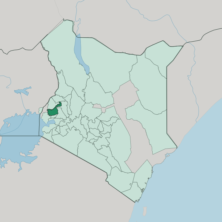


Towns & cities in Kakamega
Pick a town or city — each links to where to stay.
Most trips base in Kakamega town, the county capital and the nearest beds to the forest gate at Buyangu. Rondo Retreat and the guesthouses at Isecheno sit inside the rainforest itself, among the birds and the blue monkeys. Mumias sits in the cane belt.
For a wider choice of hotels, and the region's main airport, many travellers stay down in Kisumu, the lake city roughly an hour south of the county. Choose the town for ease; choose the forest for wildlife.
About Kakamega
Kakamega is best known for its forest.
What is Kakamega known for?
Kakamega Forest is the only tropical rainforest in Kenya, a surviving fragment of the Guineo-Congolian belt that once reached across the continent, and it draws birdwatchers for its hornbills, turacos and troops of blue monkeys. Beyond the trees, the county is Luhya country, famous for weekend bull-fights in Shinyalu and the Isukuti drumming that keeps time at them. Sugarcane rules the west around Mumias.
Just south of Kakamega town stands the Crying Stone of Ilesi, a balancing rock on the Kisumu road.
Where is Kakamega?
Kakamega lies in western Kenya, in the green highlands that rise east of Lake Victoria. The equator runs just to the south. It sits north of Kisumu and the lake's Winam Gulf, and west of the Nandi Escarpment, the wall of high ground that marks the edge of Kenya's central highlands. Uganda is not far to the west.
Most of the county is rolling farmland on a green plateau, a patchwork of maize, tea and sugarcane broken by the dark canopy of Kakamega Forest near its centre. The forest is the last Kenyan remnant of the Guineo-Congolian rainforest that once ran unbroken across equatorial Africa. Two rivers order the land.
The Isiukhu and Yala rivers both rise on the Nandi Escarpment to the east, then run west through the forest and the farms before emptying into Lake Victoria. Their valleys are steep and green. Southward the ground falls toward the lake, where the sugarcane country around Mumias spreads across the flatter, hotter lowlands near the Uganda border. Nairobi lies far to the south-east, a long day's drive across the Rift Valley.
The nearest big city is Kisumu, down on the lakeshore.
What is Kakamega like?
This is Luhya country. The county lies at the heart of the Luhya homeland in western Kenya, and around Kakamega town the Isukha and Idakho communities set much of the tone. Their best-known custom is the bull-fight.
On weekends in Shinyalu and Ikolomani, prize bulls are matched head to head before big village crowds, a contest that grew out of old post-harvest celebrations. Isukuti drumming drives the whole scene. The deep Isukuti drums, a Luhya tradition carried on UNESCO's list of intangible heritage, sound at the fights, at weddings and at the elaborate funerals the Isukha hold for their elders.
Everyday life runs on farming and trade. Maize and beans feed the households, tea grows on the higher ground, and in the south the sugarcane harvest sets the rhythm around Mumias. Luhya is the language of the home, with Swahili and English used in the markets and schools.
Kakamega town, the old provincial capital, holds the county's main market and matatu stands, and its streets fill on the twice-weekly market days. Sunday brings church and song. Music, from the Isukuti drums to gospel choirs, runs through almost everything here.
What is the history of Kakamega?
Gold made Kakamega's name. In the early 1930s prospectors poured into the district after reports of gold in the hills, a short-lived boom the Second World War brought to an end, and the mining town that sprang up gave Kakamega its start. It later served as the capital of the old Western Province.
The county in its present form is young. It was created in 2013, when Kenya's 2010 constitution replaced the provinces with forty-seven devolved counties.
What is the climate of Kakamega?
Kakamega is warm and green the year round. Its highland setting near the equator keeps the days mild rather than hot, and heavy rain falls in most months, making this one of the wettest corners of Kenya. Two rainy seasons stand out.
The long rains come in April and May; a second, shorter push arrives around August and September. Rain keeps the forest lush and the rivers running to Lake Victoria. Even the drier spells rarely stay dry for long.
How do you get to Kakamega?
The road is how most people get to Kakamega. The nearest airport with scheduled flights is Kisumu International Airport, about an hour south of the county, where flights connect to Nairobi and the coast. From Kisumu, buses and shared matatus run north to Kakamega town in under two hours.
Kakamega has its own airstrip for light aircraft. Long-distance coaches also grind up from Nairobi, crossing the Rift Valley and the highlands to reach the western towns.
Good for
Updated July 2026