Kenya
Uasin Gishu, Kenya — Towns & Travel Guide


Uasin Gishu is Kenya's high-plateau breadbasket and the training ground behind its distance runners, centred on the city of Eldoret.
About Uasin Gishu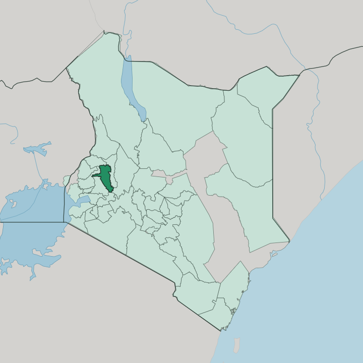


Towns & cities in Uasin Gishu
Pick a town or city — each links to where to stay.
Eldoret is where nearly every visit begins. Kenya's fifth city holds the county's hotels, the hospitals and the airport, and it makes the obvious base for the plateau. Runners and their coaches head instead for the forest camps at Kaptagat, up in the cool highlands south-east of the city. Kesses, built around Moi University and its dam, suits a quieter stay near the water.
Choose Eldoret first.
About Uasin Gishu
Two things put Uasin Gishu on the map.
What is Uasin Gishu known for?
Its flat highland plateau grows much of the maize and wheat that feed Kenya, which is why the county and neighbouring Trans-Nzoia are called the country's breadbasket. And it produces distance runners. The thin air above Eldoret has trained a long line of Kalenjin marathon and track champions, drawing coaches and athletes from across the world to camps at Kaptagat.
Farming and running define the place.
Where is Uasin Gishu?
Uasin Gishu sits on a broad highland plateau, west of the Great Rift Valley in the North Rift. It is the flattest of the Kenyan highlands. The tableland tilts gently downward from its high eastern rim along the Elgeyo escarpment above the Rift, toward the lower farmland on the western border.
Lava once capped this plateau, and its rivers have since cut deep into the old flows, leaving escarpments that look out over the Nzoia valley in the north and the Sosiani valley in the west. The Sosiani River threads through the middle of it and straight through Eldoret, whose Maasai name means stony river after that rocky bed. Grass, wheat and maize cover most of what is left.
Six counties ring it. Trans-Nzoia lies to the north, the partner in the grain country people call Kenya's breadbasket. Elgeyo-Marakwet and Baringo rise to the east along the Rift, Kericho and Nandi fall away to the south and south-west toward the tea belt, and Kakamega borders it on the west. The drop is real.
Its western farms sink toward fifteen hundred metres, while the eastern rim and Eldoret hold well above two kilometres, and that high, thin air over the city is exactly why runners come.
What is Uasin Gishu like?
Two cultures share the plateau, and both revolve around the land. This is Kalenjin country first of all, and the Kalenjin gift for distance running shapes daily life more than any monument does. Before dawn, dirt roads outside Eldoret fill with runners in packs, and the discipline that turns village children into Olympic champions is a local craft passed down at camps like Kaptagat and across the county line at Iten.
Farming is the other half. Wheat, maize and dairy herds have drawn Kalenjin, Kikuyu and settler families onto the same red-soil farms for a century, and Sunday markets in the small towns still trade the plateau's grain and milk. Eldoret gives the county its urban edge.
The city carries one of Kenya's largest student bodies, anchored by Moi University out at Kesses, and that keeps the streets young and loud. Swahili and English are the shared tongues of trade and school. Kalenjin is the mother language of the hills, and its Nandi dialect fills the market crowds.
Grain and dairy are the plateau's true exports, the maize and wheat of the breadbasket leaving alongside milk and the cheese from the Doinyo Lessos dairies.
What is the history of Uasin Gishu?
The plateau takes its name from the Uasin Gishu Maasai, a pastoral clan who grazed cattle here before the Nandi pushed in from the south. Both lost the high grassland to colonial settlement. Afrikaner ox-wagon families trekked up from South Africa in 1908 and laid out farms, and the plot known as Farm 64 became the town of Eldoret in 1912.
The Uganda Railway reached it in 1924. Sirikwa herders, an Iron Age people, had worked these same pastures long before any of them. Kenya carved the modern county from the old district in 2013.
What is the climate of Uasin Gishu?
Altitude, not distance from the equator, sets Uasin Gishu's weather. The plateau stands high enough that days stay mild and green while nights turn genuinely cold, even though the equator runs close by. Rain is the plateau's real wealth.
Two wet spells, the long rains from around March and shorter rains later in the year, soak the wheat and maize, with drier, brighter windows in January and again from June. The thin highland air is also what draws runners to Eldoret.
How do you get to Uasin Gishu?
Most travellers come through Eldoret. Eldoret International Airport, out on the plateau, runs daily hops to Nairobi and handles some of Kenya's busiest air freight, mostly flowers and produce. By road, the Trans-African Highway climbs west from Nairobi, drops through the Great Rift Valley and lifts onto the plateau.
The Uganda Railway still crosses the county, though it hauls freight rather than passengers. Fly in, or make the long drive up.
Updated July 2026