Lebanon
Mohafazat Béqaa, Lebanon — Towns & Travel Guide


Mohafazat Béqaa is Lebanon's fertile eastern valley, a wine country of vineyards set between Mount Lebanon and the Anti-Lebanon range.
About Mohafazat Béqaa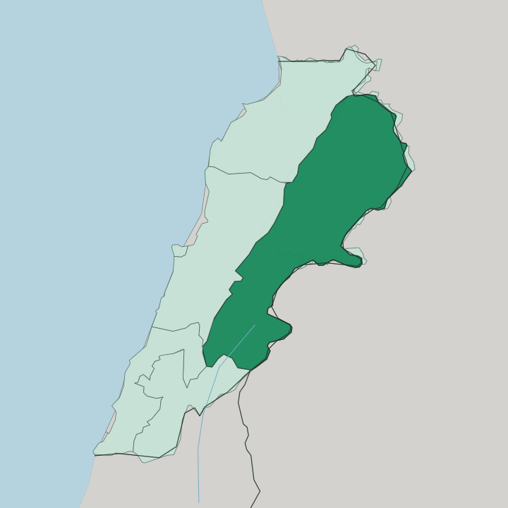
Towns & cities in Mohafazat Béqaa
Pick a town or city — each links to where to stay.
Zahlé is the obvious base, the governorate's capital and the town where most Béqaa trips begin, with restaurants strung along the Berdawni gorge. Chtaura sits at the crossroads. It straddles the Beirut-Damascus highway midway up the valley, so hotels there put you a short drive from Zahlé, the Anjar ruins, and the Château Ksara cellars.
Pick Zahlé for the food and the gorge; pick Chtaura when you want the highway and the wineries within easy reach.
About Mohafazat Béqaa
What is Mohafazat Béqaa known for?
This is Lebanon's wine country. The Béqaa Valley floor, ringed by Mount Lebanon to the west and the Anti-Lebanon range along the Syrian border to the east, holds most of the vineyards and much of the country's farmland, and its estates ship wine and arak far beyond Lebanon. Zahlé, the governorate's capital, lines the Berdawni gorge with open-air restaurants and is nicknamed the Bride of the Béqaa.
Anjar adds a rare survivor: the ruins of a planned Umayyad city, walled and quartered on a Roman grid.
Where is Mohafazat Béqaa?
Mohafazat Béqaa fills the broad interior valley of eastern Lebanon, hard against the Syrian border. It is one trough. Mount Lebanon rises along its western side, cutting the valley off from Beirut and the Mediterranean coast, while the Anti-Lebanon range walls the eastern edge and carries the frontier with Syria.
This is the Béqaa Valley, the northern reach of the Great Rift that runs down through the Levant. The floor is high, flat farmland. It drains two ways from a low watershed near the middle.
The Litani rises here and runs south down the valley before bending west to reach the Mediterranean. The Orontes rises on the eastern side and flows the other way entirely, north out of Lebanon and on through Syria toward Turkey. Zahlé, the capital, sits where the valley meets the foot of Mount Lebanon, above the plain on the Berdawni gorge.
Chtaura holds the road crossing on the Beirut-Damascus highway. Anjar lies south near the frontier. The valley is long and narrow, and the mountains stand in view on either hand.
What is Mohafazat Béqaa like?
The Béqaa lives off its land, and the culture follows the vine. Grapes are the heart of it. The valley grows most of Lebanon's wine, and its estates also distil arak, the aniseed spirit poured from the cellars of Zahlé to tables across the country.
Zahlé wears that identity openly. The capital calls itself the city of wine and poetry, and its long line of restaurants down the Berdawni gorge serves mezze and grilled meats with arak through the day and into the night. The valley is mixed in faith and language.
Christians form the largest community here, alongside Sunni and Shia Muslims and a Druze minority, and Arabic is the common tongue of the whole governorate. Anjar carries a second thread: it was resettled by Armenians in the twentieth century, and the town keeps its own churches and cooking apart from the valley around it. Food is the shared language of the place.
Mezze, orchard fruit and the valley's wine anchor a table that draws visitors up from Beirut on weekends. The mountains hem the valley on both sides, and life runs along its floor.
What is the history of Mohafazat Béqaa?
The Béqaa's flat, watered floor made it granary country long before it made wine. Under Rome it fed the provinces of the Levant with grain. Its most striking ruin comes later, from the early eighth century, when the Umayyad caliph al-Walid I laid out the walled city of Anjar on a Roman grid near the Syrian border.
Zahlé is a far younger place, a Christian town founded in the eighteenth century where the valley meets Mount Lebanon, and it rose on the trade in grapes, wine and arak that still defines the Béqaa. Grain gave way to the vine.
What is the climate of Mohafazat Béqaa?
The Béqaa has a Mediterranean climate turned continental by its height and its mountain walls. The Béqaa's winters are harsh. They are cold and often snowy, with the peaks of Mount Lebanon and the Anti-Lebanon range white above the valley floor, while summers are dry and warm on the plain below.
The two flanking ranges wring the rain out of the sea air before it reaches the valley, so the Béqaa is markedly drier than the coast around Beirut, and it is the melt and springs off those slopes, more than the rain, that feed the Litani and keep the vineyards watered through the long dry summer.
How do you get to Mohafazat Béqaa?
Nearly everyone arrives from Beirut. The capital and its airport sit on the coast, and the Beirut-Damascus highway climbs over the Mount Lebanon range and drops into the valley at Chtaura, the Béqaa's road junction. From there Zahlé is a few minutes on, and the same highway runs east toward the Syrian border past Anjar.
There is no coast and no airport in the valley itself, so the mountain road from Beirut is the way in for most visitors, and inside the governorate travel is by car along the valley floor.
Good for
Updated July 2026