Lebanon
Mohafazat Nabatîyé, Lebanon — Towns & Travel Guide


Mohafazat Nabatîyé is the heart of Jabal Amel, southern Lebanon's Shia highland, where the Litani River bends below Beaufort Castle.
About Mohafazat Nabatîyé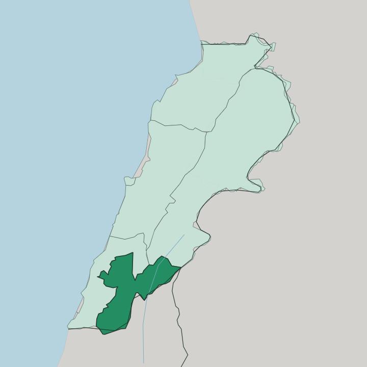
Towns & cities in Mohafazat Nabatîyé
Pick a town or city — each links to where to stay.
Nabatieh is the natural base. The capital carries the governorate's hotels and its Monday souk, and it sits central to the four districts. Marjayoun stands off to the southeast on its ridge, facing Mount Hermon and looking west over the Litani River toward Beaufort Castle.
Hasbaya lies further east again, a Druze town at the foot of Jabal al-Sheikh. Choose Nabatieh for the market and the commemorations; head to Marjayoun or Hasbaya if you want the quiet border hills and are content with a scarce bed.
About Mohafazat Nabatîyé
This is the Shia south.
What is Mohafazat Nabatîyé known for?
The governorate takes its name from Nabatieh, the market town that anchors the wider Jabal Amel region and sits about 73 kilometres south of Beirut. Each year Nabatieh hosts the largest Ashura commemoration in Lebanon, when processions fill its streets to mourn the martyrdom of Imam Hussein. Tobacco is the crop that pays here, terraced across the hills alongside olives, figs, and grapes.
Above the Litani River, the Crusader ruin of Beaufort Castle keeps watch over it all.
Where is Mohafazat Nabatîyé?
Mohafazat Nabatîyé fills the inland highlands of southern Lebanon, the country's smallest governorate by area yet its Shia heartland. It is the upland core of Jabal Amel, the mountainous region that runs between the Mediterranean coast and the inland valleys. Four districts divide it.
Nabatieh holds the centre, Bint Jbeil the west, Marjayoun the southeast, and Hasbaya the far northeast under the shoulder of Mount Hermon. The Litani River draws the eastern edge, cutting a deep valley before it bends sharply west near Marjayoun and runs down toward the sea north of Tyre. On a rock above that bend stands Beaufort Castle, on a cliff that drops steeply to the water below.
Mount Hermon, which the Arabic calls Jabal al-Sheikh, rises to the east on the Syrian border, its snows feeding the springs of the Wadi al-Taym around Hasbaya. Ridges and terraced slopes make up most of the land between. Beirut lies to the north, a couple of hours by road.
The southern boundary is the frontier itself, and the hills here have long felt close to it. Little of the governorate is flat. It is a country of tobacco terraces, olive groves, and stone villages strung along the ridgelines.
What is Mohafazat Nabatîyé like?
The pulse of this governorate is Shia. Jabal Amel has been a centre of Twelver Shia scholarship for centuries, and its clerics and jurists once carried that learning as far as Safavid Persia. That heritage is worn openly.
Nowhere is it plainer than in Nabatieh at Ashura, when the town stages the biggest commemoration of Imam Hussein's death in the whole of Lebanon, and black-clad processions move through the streets in mourning. Village life turns on the land and the family. Tobacco is the cash crop that has held these hills together, worked plot by plot on narrow terraces, and olives, figs, and grapes fill out the harvest.
The rhythm is old and rural. In Nabatieh the week gathers to a head on Monday, when the souk fills with sellers coming down from the surrounding villages to trade. The east has another face.
Hasbaya and its valley are largely Druze, a community set apart by its own faith and customs at the foot of Mount Hermon, so the governorate holds more than one religious world within its borders. Marjayoun adds Christian streets and old churches to the mix. Arabic is the language spoken throughout.
What binds it is the mountain south itself, hard-working and self-contained.
What is the history of Mohafazat Nabatîyé?
These hills have changed hands often. Beaufort Castle above the Litani was taken by Fulk, King of Jerusalem, in 1139, lost to Saladin in 1190, and finally seized for the Muslim armies by Sultan Baibars in 1268. Below the fortress at Marj Ayyun, the Ayyubids had already beaten the Crusaders in battle in 1179.
Through the Ottoman centuries Jabal Amel remained a distinct Shia country of scholars and tobacco farmers, ruled at a distance and often left to itself. The governorate itself is a modern creation, carved from the older South Lebanon and named for its capital at Nabatieh.
What is the climate of Mohafazat Nabatîyé?
The climate is Mediterranean, tempered by height. Nabatieh sits on its plateau well above the coast, so summers stay hot and dry while the nights turn cooler than they do down by the sea. Winters bring the rain that feeds the tobacco terraces, and the higher ground toward Hasbaya can see cold snaps off Mount Hermon, whose snows linger on the summit well into spring.
The uplands are green after the winter rains and burnt gold by late summer. Weather here follows the mountain, not the shore.
How do you get to Mohafazat Nabatîyé?
The gateway is Beirut. Rafic Hariri International Airport, on the capital's southern edge, is the only civil airport for the whole country, and it lies about 73 kilometres north of Nabatieh. From there the road runs south, dropping off the coastal highway to climb inland into the Jabal Amel hills.
Nabatieh has no rail line. A car is close to essential once you leave the capital, since the villages, Beaufort Castle, and the border towns of Marjayoun and Hasbaya are scattered across ridges that public transport barely reaches. Roads wind, but distances are short.
Good for
Updated July 2026