Lebanon
Mohafazat Aakkâr, Lebanon — Towns & Travel Guide


Akkar is Lebanon's northernmost governorate, a fertile coastal plain rising to forested mountains along the Syrian border.
About Mohafazat Aakkâr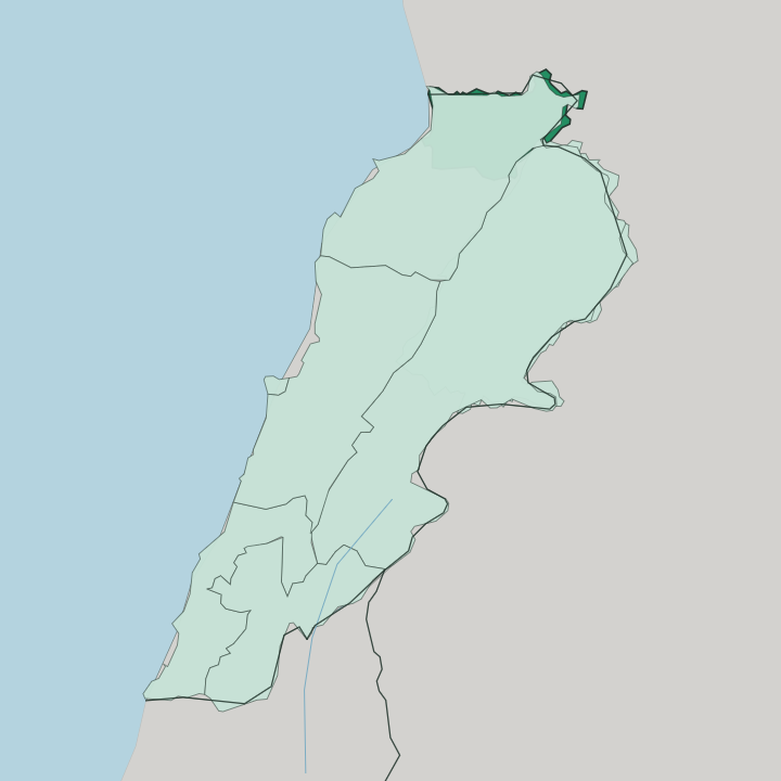
Towns & cities in Mohafazat Aakkâr
Pick a town or city — each links to where to stay.
Akkar keeps few hotels. Halba, the capital, sits on the plain and puts you within a short drive of the coast, the border markets, and the roads that climb inland. It suits you if you want services and a launch point rather than a scenic room.
Up in the mountains, Al-Qoubaiyat is the largest Christian village in the governorate and the usual choice for hikers and summer visitors, with pine forest, cold streams, and snow on the higher slopes each winter. Many travellers instead sleep in Tripoli, an hour south, and make Akkar a day trip.
About Mohafazat Aakkâr
Akkar is farm country first.
What is Mohafazat Aakkâr known for?
Its western coastal plain is the second-largest agricultural region in Lebanon, trailing only the Beqaa Valley, and its fields of wheat, potatoes, and citrus feed much of the north. The land climbs east through mid-elevation plateaus to forested mountains that reach the Syrian frontier. Halba is the small administrative capital that anchors it.
Few travellers reach this corner, which is exactly why its cedar-clad heights and unhurried villages stay largely to themselves.
Where is Mohafazat Aakkâr?
Akkar occupies the far north of Lebanon, the last governorate before Syria. The land reads as three long steps. A broad coastal plain spreads along the Mediterranean Sea in the west, watered and fertile, and this is where most of the farming and most of the people are.
Behind it the ground climbs into mid-elevation plateaus, with olive terraces and scattered villages breaking up the slopes. Higher still, forested mountains rise toward the eastern edge, their pine and remnant cedar stands giving the governorate its wilder, cooler character above the plain. The Nahr al-Kabir marks the northern line.
This southern Great River runs west along the border with Syria and empties into the Mediterranean near the coast. North Governorate lies to the south and Baalbek-Hermel to the south-east. Halba, the capital, sits down on the plain rather than up in the hills. The whole governorate covers only about 788 km2, compact enough to cross in an afternoon.
Nothing in Akkar lies far off. That tight range from shore to summit is the point.
What is Mohafazat Aakkâr like?
Akkar is rural Lebanon at its plainest. This is the least urbanised governorate in the country, and most people live in villages scattered across the plain and the hills rather than in any single town. The population is mostly Sunni Muslim, with a substantial Christian minority and one of Lebanon's larger Alawite communities in the border villages.
Al-Qoubaiyat, high in the mountains, is the largest Maronite village here and keeps its own church calendar and feast days. That mix sits close together across a small governorate. Land has always mattered more than anything else.
For most of the last century a handful of families held the great estates while villagers worked them, and the memory of that imbalance still colours local politics. Arabic is the everyday language, spoken with a northern Lebanese accent. Food follows the fields.
Wheat, wild greens, olive oil, and freekeh come off the plain and the terraces, and the cooking stays simple and generous. Hospitality to the rare outside visitor is warm and unforced. This is a place that has been overlooked, and it knows it.
What is the history of Mohafazat Aakkâr?
Akkar is a young governorate over old ground. It was carved out of North Governorate by law in 2003, one of Lebanon's newest first-level divisions, though the appointment of a governor and its full working start came only years later. The land itself has been settled far longer.
Through the Ottoman centuries the sharifian Al Merehb family ruled much of Akkar from the early eighteenth century, and their reach once stretched south toward Tripoli and beyond. After the First World War the region passed under the French Mandate with the rest of Lebanon. Modern Akkar carries both histories at once.
What is the climate of Mohafazat Aakkâr?
Akkar's weather splits by altitude. The coastal plain along the Mediterranean Sea has the hot, dry summers and mild, wet winters of the Lebanese shore, and its rains fall mostly between autumn and spring. Climb east into the mountains and everything cools.
The higher villages around Al-Qoubaiyat draw real snow each winter, enough to close roads and to turn the pine slopes white for weeks. Rain feeds the plain's farms. That gap between warm shore and snowbound heights is what makes the governorate green.
How do you get to Mohafazat Aakkâr?
Most visitors reach Akkar by road from the south. Beirut, with the country's only international airport, lies well down the coast, and the drive north runs through Tripoli before entering the Akkar plain. Tripoli is the practical staging point, roughly an hour from Halba. From the capital at Halba, roads fan out to the coast, up into the mountains around Al-Qoubaiyat, and east toward the Syrian border.
There is no railway here. A hire car or a shared taxi is the only real way to move around.
Good for
Updated July 2026