Turkey
Rize, Turkey — Towns & Travel Guide


Rize is Turkey's tea country, a rain-soaked strip of the eastern Black Sea coast rising fast into the Kaçkar Mountains.
About Rize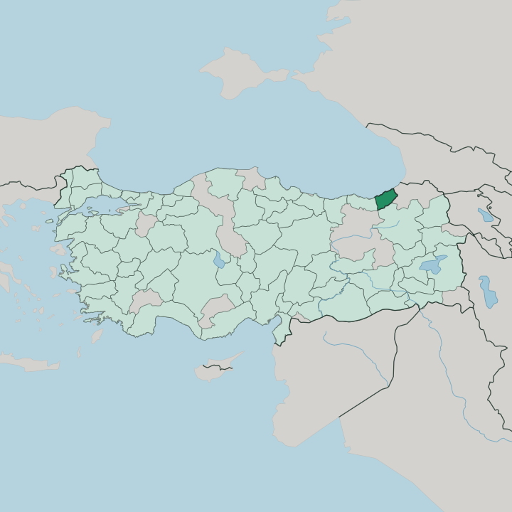


Towns & cities in Rize
Pick a town or city — each links to where to stay.
Three bases divide the province. Rize, the seat, sits on the coast where the tea gardens start on the slopes above the harbour, the easiest first stop and the closest to the airport. For the mountains, Ayder is the usual overnight, a thermal-spring village high in Çamlıhemşin within reach of the Fırtına valley, Zilkale and the Kaçkar passes. Çayeli, east along the coast road, puts you in the middle of the tea harvest, its terraces and factories running up the hillsides.
Pick the coast for ease, the highland for walking.
About Rize
Rize means tea.
What is Rize known for?
The steep, wet hills above the Black Sea coast grow most of the tea Turkey drinks, and the terraces climb almost to the doorsteps of the villages. Behind them the Kaçkar Mountains rise sharply, the highest wall of the Pontic range, threaded with glacial valleys and highland pastures. The Fırtına valley cuts inland through Çamlıhemşin toward the medieval tower of Zilkale, and the thermal springs at Ayder draw walkers up into the range.
It is a province of rain, river and leaf.
Where is Rize?
Rize sits in the north-east of Turkey, on the eastern Black Sea coast between the provinces of Trabzon to the west and Artvin to the east. It is a narrow province. The coast is a thin shelf of towns and tea terraces, and behind them the land tilts up almost at once into the Pontic Mountains.
Only a few kilometres inland the slopes are steep enough to need footpaths rather than roads. The Kaçkar Mountains form the province's southern wall, the highest and most eastern block of the Pontic range, holding snow and small glaciers high in its cirques well into summer. Rivers do the shaping here.
The Fırtına rises in the Kaçkar and falls through Çamlıhemşin in a deep forested gorge, past the stone tower of Zilkale, toward the sea. Higher up lie the yaylas, the summer meadows such as Ayder and Pokut where herders move their animals once the snow clears from the passes. Beyond them the country changes.
South over the watershed the land drops away toward Erzurum and the dry Anatolian interior, a different world of high open plains. Rain and green on one side, stone and steppe on the other.
What is Rize like?
Rize is one of the old homelands of the Laz, a people of the eastern Black Sea whose own language, kin to Georgian, is still heard in the coastal villages. Inland, in the high valleys above Çamlıhemşin, live the Hemshin, descended from Armenians who settled these mountains more than a thousand years ago and later took up Islam. Turkish and Georgian families share the same coast.
The old name for the whole district was Lazistan. Music binds the mix. The horon, a fast line dance driven by the shrill three-stringed kemençe, is danced at weddings the length of the province, shoulders shaking to the beat.
Tea rules daily life more than any monument. The narrow-waisted glass is poured dark and constant, in homes, shops and the ferry-boat cafés, and the plucking season sets the rhythm of the summer. Above the coast the culture turns pastoral.
When the heat rises, families climb to the yaylas, the highland pastures such as Ayder, to graze cattle, make butter and cheese, and hold the summer festivals. Wooden houses stand on stone footings along the slopes. It is a rain-fed, green corner of Turkey, closer in feeling to the Caucasus than to Anatolia.
What is the history of Rize?
The coast has been settled since antiquity, held in turn by Greeks and the Byzantine Empire, whose emperor Justinian brought the Laz tribes of the interior under central rule. Armenians fleeing the Arab conquests reached the high valleys around 790 and became the Hemshin. Ottoman forces took the region in 1547 and governed it as the sanjak of Lazistan.
That name stuck for centuries. The turn came with a leaf. Tea was first planted here experimentally in 1912 and, once large harvests began in the 1940s, it lifted a poor and remote province into the centre of an entire national industry.
What is the climate of Rize?
Rize is the wettest place in Turkey. Rain falls in every month, spread evenly through the year rather than saved for one season, and the totals here are the highest the country records. The Black Sea feeds the clouds and the Pontic wall wrings them out, so the seaward slopes stay soaked and green while the peaks hold snow.
Winters on the coast are mild, summers warm and humid. It is exactly the weather the tea wants, and the terraces owe their existence to it.
How do you get to Rize?
Most who come to Rize arrive on a scheduled flight. The Rize-Artvin Airport, built on reclaimed ground out in the Black Sea near Pazar, puts scheduled flights on the province's own doorstep, and the larger airport at Trabzon lies a short drive west along the coast. From either, the shore highway runs the length of the province, linking the coastal towns and carrying on east toward the Georgian border at Hopa.
Getting inland is slower. A mountain road climbs south over the passes to Erzurum, and the side valleys such as the Fırtına are reached only by narrowing roads that end where the footpaths to the yaylas begin.
Good for
Updated July 2026