Ukraine
Autonomous Republic of Crimea, Ukraine — Towns & Travel Guide


A peninsula republic of Ukraine on the Black Sea, its mountains meeting the water along the Crimean Riviera.
About Autonomous Republic of Crimea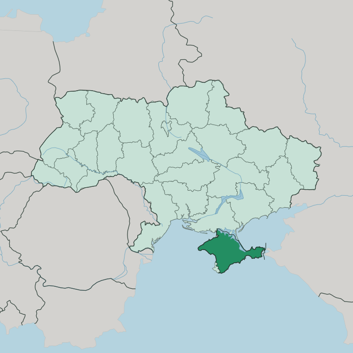
Towns & cities in Autonomous Republic of Crimea
Pick a town or city — each links to where to stay.
Base yourself inland or by the sea. Simferopol, the capital on the Salhir River, is where arrivals land and where the road and rail lines of the peninsula fan out toward every corner of it. Yalta and the Southern Coast hold the resorts, the palaces, and the warmest weather, below the Crimean Mountains against the Black Sea.
Bakhchysarai keeps another mood. The old Crimean Tatar capital sits inland among the foothills, built around its khans' palace and quiet after dark. Choose Simferopol to move on; choose the coast around Yalta when the sea and the mountain wall behind it are the whole reason you came.
About Autonomous Republic of Crimea
What is Autonomous Republic of Crimea known for?
The Autonomous Republic of Crimea is Ukraine's island-like south, a diamond of land pushed out into the Black Sea. Simferopol sits at its centre. The capital lies inland on the Salhir River, and most journeys through the region pass through it before reaching the coast.
To the south the Crimean Mountains rise in a wall of forested limestone, dropping to the resort strip that Soviet holidaymakers knew as the Crimean Riviera. Yalta anchors that coast. The Crimean Tatars, the peninsula's native Turkic people, gave the land its palaces, its mosques, and much of its older character.
Where is Autonomous Republic of Crimea?
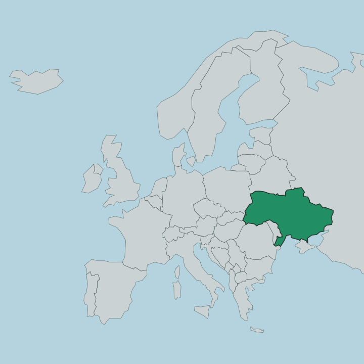
The Autonomous Republic of Crimea covers most of the Crimean Peninsula, the diamond of land that Ukraine pushes south into the Black Sea. Only Sevastopol lies outside it. That city holds special status of its own on the south-western tip, while the republic wraps around it and takes in the rest of the peninsula.
To the east the shallow Sea of Azov laps the peninsula's northern shoulder, half-cut off from the open water. The land barely joins the mainland at all. The Isthmus of Perekop, a strip only 5 kilometres across at its narrowest, is the single thread of ground tying Crimea to Kherson Oblast to the north.
Inside that frame the country splits into three. The north and centre are dry steppe, flat and open, running down from Perekop toward Simferopol on the Salhir River. Then the ground lifts.
The Crimean Mountains climb in three parallel limestone ranges above the southern edge, and Roman-Kosh crowns them at 1545 metres, the highest point on the whole peninsula. Below the mountains the land falls away fast to a narrow warm coast facing the Black Sea, and Yalta sits along that shelf where the slopes drop almost straight into the water.
What is Autonomous Republic of Crimea like?
The Crimean Tatars are the thread that runs through the peninsula's culture. This Turkic people is native to Crimea, and for centuries the Crimean Khanate ruled from Bakhchysarai in the foothills. The Khan's Palace still stands there.
Its mosque and harem and its walled fountain courts make it one of the few surviving Muslim palace complexes in Europe, and the gardens gave the region its Tatar face long before Russian villas lined the coast. Islam, the Tatar language, and a cuisine of pastries and grilled meat all trace back to that court. Then came the resort century.
When Crimea became the holiday coast of the Russian empire and later the Soviet Union, a second culture layered over the first. Grand villas, sanatoria and imperial palaces went up along the Southern Coast around Yalta, and the writer Anton Chekhov kept a house above the town. The two worlds sit side by side.
A Tatar mosque in Bakhchysarai and a tsar's palace near Yalta belong to the same small peninsula, and Ukrainian, Russian and Crimean Tatar have all carried official weight across the republic.
What is the history of Autonomous Republic of Crimea?
Empires stacked up here. Greeks, Scythians and Goths held the peninsula long before the Crimean Tatars did, and the Crimean Khanate that followed them ruled from Bakhchysarai until the Russian empire annexed the whole of Crimea in 1783. Sevastopol grew into the empire's great Black Sea naval base.
The port then stood at the heart of the Crimean War siege in the 1850s, one of the bloodiest of its century. Under Ukraine the peninsula won its present autonomous status in 1991, with Simferopol as capital. Russia annexed Crimea in 2014, a move Ukraine and most of the world reject, so the republic stays Ukrainian in law.
What is the climate of Autonomous Republic of Crimea?
Two climates share one peninsula. The steppe of the north and centre around Simferopol runs hot and dry through a continental summer, with cold snaps in winter and little shelter on the open plain. The Southern Coast is another matter.
Screened by the Crimean Mountains and warmed by the Black Sea, the strip around Yalta keeps a mild, humid climate close to Mediterranean, its winters soft and its summers long and warm. That wall of mountains is what splits the weather in two.
How do you get to Autonomous Republic of Crimea?
Simferopol is the gate. The capital holds the peninsula's main airport and its rail junction, and almost every arrival passes through it before heading for the coast. Reaching Crimea overland from the rest of Ukraine means crossing the Isthmus of Perekop, the thin neck of land into Kherson Oblast in the north.
From Simferopol the road climbs south over the Crimean Mountains to Yalta. That run is served by the Crimean Trolleybus, an 86 kilometre line down to the coast that is the longest trolleybus route anywhere.
Good for
Updated July 2026