Egypt
Kafr ash Shaykh, Egypt — Towns & Travel Guide


Kafr ash Shaykh is a governorate of the northern Nile Delta, between the Rosetta branch and the Mediterranean coast.
About Kafr ash Shaykh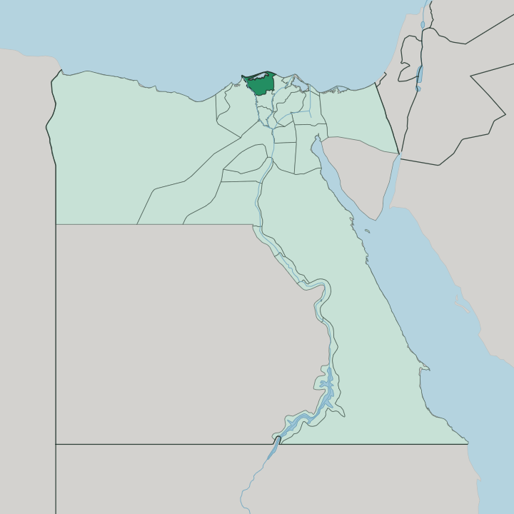
Towns & cities in Kafr ash Shaykh
Pick a town or city — each links to where to stay.
Two bases bracket the governorate. Kafr el-Sheikh, the inland capital, is the workaday choice, close to the ancient mound of Sakha and the farmland along the Rosetta branch. Baltim is the other, a summer resort spread along the Mediterranean sand where the dunes wall the sea off from Lake Burullus.
Older river towns lie between them. Fuwwah and Desouk both stand on the Rosetta branch, thick with mosques and shrines but thin on hotel beds. Pick Kafr el-Sheikh for the Delta interior, Baltim if you want the coast.
About Kafr ash Shaykh
Farmland and water define this governorate.
What is Kafr ash Shaykh known for?
The Nile Delta plain here grows rice and cotton alongside wheat and maize, fed by the Rosetta branch that runs along its western edge for some 85 kilometres. Across the north stretches Lake Burullus, the second-largest natural lake in Egypt, a brackish lagoon of fishing boats and reed beds sealed off from the Mediterranean by a thin ribbon of dune. The capital, Kafr el-Sheikh, sits inland about 134 kilometres north of Cairo.
Fishing villages and old mosque towns fill the rest.
Where is Kafr ash Shaykh?
Kafr ash Shaykh occupies the north-central Nile Delta, one of the fan of provinces that share the flat alluvial plain where the Nile fans out toward the sea. The Rosetta branch, the western of the river's two surviving Delta arms, forms much of its boundary, curving past Fuwwah and Desouk before reaching the coast to the west at the town that gave the branch its name. The Mediterranean Sea closes the whole northern edge.
Along that edge lies Lake Burullus, a shallow brackish lagoon and the second-largest natural lake in Egypt, cut off from the open water by a narrow bar of sand and dune. Fishermen work it from the shore villages. Inland the land is table-flat and intensely farmed. Gharbia Governorate borders it to the south and Beheira to the west, across the Rosetta branch, while Dakahlia lies to the east.
The provincial capital, Kafr el-Sheikh, stands in the interior, roughly 134 kilometres north of Cairo up the Delta. Little rises here. Canals, drains and the two great lobes of river and lake divide the province more than any hill or ridge ever could, and the whole of it slopes so gently toward the Mediterranean that sea, lake and farmland blur into one another along the north.
What is Kafr ash Shaykh like?
This is a rural, deeply Muslim corner of the Delta, and its culture is built around the mosque, the shrine and the field. Fuwwah shows it best. The old river town on the Rosetta branch is counted the third heritage city of Egypt, after Cairo and Rashid, and is known across the country for its dense cluster of historic mosques and Ottoman-era merchant houses.
Desouk carries the other strand. Its great mosque holds the tomb of Ibrahim al-Desouki, a 13th-century Sufi saint, and the moulid held in his honour draws pilgrims from across the Delta. Away from the towns, life follows the water and the harvest.
Arabic is the language everywhere. The rhythm of the year turns on rice and cotton in the fields and on the fishing season out on Lake Burullus, where reed-cutters and net-fishermen work a lagoon alive with migrating birds. Handicrafts survive in the old centres, weaving and pottery among them.
Food leans on the Delta's own produce, rice and freshwater fish above all. It is a working landscape rather than a polished one, and that plainness is much of its character.
What is the history of Kafr ash Shaykh?
People have farmed this Delta ground since pharaonic times. Near Kafr el-Sheikh lies the mound of Sakha, the ancient town of Xois, once capital of its own nome and remembered as the seat of the shadowy 14th Dynasty kings of the Second Intermediate Period. Under Islam the river towns of Fuwwah and Desouk grew into centres of trade and Sufi devotion along the Rosetta branch.
The modern governorate itself is young. It was carved out as a separate province in 1949, taking its name from the capital, Kafr el-Sheikh.
What is the climate of Kafr ash Shaykh?
The coast is mild, the interior hotter. Along the Mediterranean at Baltim, sea winds hold summers moderately warm and humid and winters mild, with the province's little rain falling in the cooler months. Inland toward Kafr el-Sheikh the sea's reach fades and summer days run hotter and drier over the open farmland.
Rain is scarce either way. It is the Nile water in the canals, not the sky, that keeps the Delta green.
How do you get to Kafr ash Shaykh?
Most travellers come up from Cairo. The capital lies roughly 134 kilometres north of the city, reached by road and rail across the Delta, and the international gateway for the whole region is Cairo's airport rather than anything local. Within the governorate, roads follow the Rosetta branch and the canals, linking Kafr el-Sheikh with the river towns of Fuwwah and Desouk and running north to the coast at Baltim.
There is no airport of its own.
Good for
Updated July 2026