Egypt
Muḩāfaz̧at Asyūţ, Egypt — Towns & Travel Guide


Towns & cities in Muḩāfaz̧at Asyūţ
Pick a town or city — each links to where to stay.
Almost every bed in the governorate is in Asyut city, on the west bank of the Nile. It is the base. From there the river towns are short hops: Manfalut and Dairut lie north toward Minya, Abu Tig and El Qusiya spread south toward Sohag, and the old Badarian ground of El Badari sits east of the river.
Stay in Asyut city for the university, the barrage, and the road out to the Durunka monastery; the smaller towns are day-trips rather than places to sleep.
About Muḩāfaz̧at Asyūţ
Asyut sits at the heart of Upper Egypt.
What is Muḩāfaz̧at Asyūţ known for?
Its old capital was Lycopolis, the Graeco-Roman "city of the wolf," and the governorate still carries one of Egypt's strongest Coptic Christian communities, drawn each year to the cliffside monastery at Durunka. The Nile threads the whole province, feeding cotton fields and lentil plots along a narrow green floor. Silver-thread shawls are woven here.
Where is Muḩāfaz̧at Asyūţ?
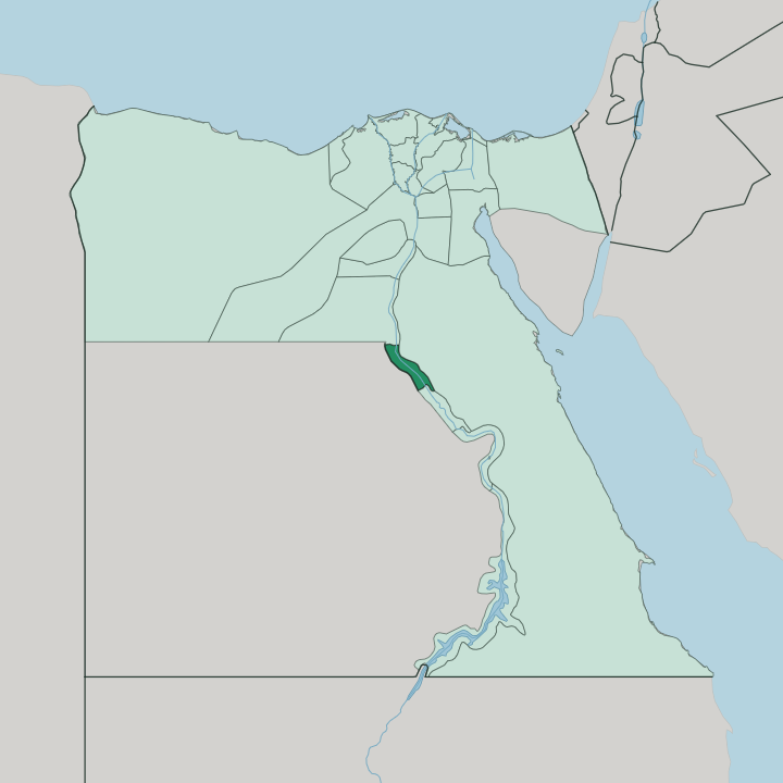
Asyut occupies the middle of Upper Egypt, roughly halfway along the Nile between Cairo and Aswan. The governorate is really a valley. The settled land forms a long green ribbon that follows the river for about a hundred miles and rarely widens beyond a dozen, hemmed on both sides by bare limestone escarpments that rise some 600m from the floodplain.
Minya lies to the north and Sohag to the south, so the province is a link in the chain of Nile governorates that make up the south of the country. The capital, Asyut city, stands on the western bank. Desert takes over the moment the fields end.
West of the cultivated strip the Western Desert plateau climbs away toward the New Valley, and east of the river the Eastern Desert hills wall off the Red Sea coast. Everything human here clings to the water. Two engineering works pin the province to the river: the Asyut Barrage, a low dam thrown across the Nile at the turn of the twentieth century, and the Ibrahimiya Canal, which draws off the left bank at Asyut and runs north for sixty kilometres before dividing at Dairut.
Between desert wall and canal head, the whole governorate is water and the land it feeds.
What is Muḩāfaz̧at Asyūţ like?
Faith shapes Asyut more than almost anything else. The governorate holds one of the densest Coptic Christian populations in Egypt, and about half the people of the capital belong to that church. Each August the Convent of the Virgin Mary at Durunka, cut into the cliffs above the fields south of Asyut city, draws pilgrims in the hundreds of thousands for the feast of the Assumption.
Old monastic settlements are scattered along the desert edge. Christianity here is not a museum piece; it is lived, on the same ground where the Wepwawet wolf cult once ran. Craft is the other thread.
Asyut is one of the last places that still makes silver appliqué-work shawls, the metal-on-tulle weave that took the city's name abroad, and its workshops also turn out pottery, inlaid woodwork, and rugs. Beyond the workshops, the province lives by its land. Cotton, grains, lentils, and vegetables come off the Nile fields, and the rhythm of planting and flood-fed irrigation still orders the year.
It is a working farm province with a deep religious life, not a resort. That plainness is much of its character.
What is the history of Muḩāfaz̧at Asyūţ?
Asyut's story starts deep in prehistory. The Badarian culture, Egypt's earliest known farming society, was first dug up at El Badari on the province's eastern desert edge. By the dawn of the pharaonic age the town was already the seat of the Thirteenth Nome of Upper Egypt, and its Graeco-Roman successor, Lycopolis, took its "wolf city" name from the local worship of the jackal-gods Wepwawet and Anubis.
Rock-cut tombs still pit the western cliffs above the modern city. From nome capital to caravan town, Asyut has held the middle Nile for five thousand years.
What is the climate of Muḩāfaz̧at Asyūţ?
Asyut ranks among the driest places in Egypt. Its climate is hot desert, and rain barely registers from one year to the next. Summers are fierce, with June-to-August afternoons pushing toward the high thirties on the exposed Nile valley floor, while winters turn mild and pleasant by day and can drop cold after dark once the desert releases its heat.
The escarpments on either side of the river trap the sun and give the province its scorching, cloudless character.
How do you get to Muḩāfaz̧at Asyūţ?
Trains are the usual way in. Asyut city sits on the main Cairo-to-Aswan railway that runs the length of the Nile valley, so it is a straightforward ride south from the capital. The city also has its own airport.
Opened in the 1970s on the desert edge west of town, it carries domestic and some regional flights for travellers skipping the long rail journey. Within the governorate a single valley road and the rail line tie the river towns together, from Manfalut in the north down through Asyut to Abu Tig. Everything follows the river.
Updated July 2026