Egypt
Muḩāfaz̧at al Minyā, Egypt — Towns & Travel Guide


Muḩāfaz̧at al Minyā stretches along the Nile through Middle Egypt, a farm belt of ancient tombs, Coptic monasteries, and cotton wealth.
About Muḩāfaz̧at al Minyā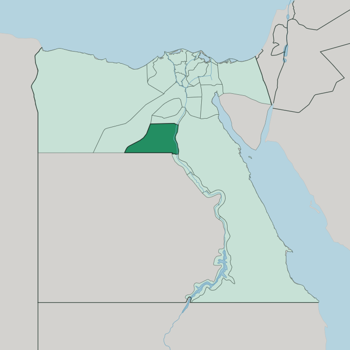
Towns & cities in Muḩāfaz̧at al Minyā
Pick a town or city — each links to where to stay.
Almost everyone bases in Minya, the governorate capital on the western bank of the Nile, which offers the only real spread of hotels and a Nile-side setting within road reach of the main sites. Beds elsewhere are scarce. Mallawi, further south, puts you nearer Tell el-Amarna and Tuna el-Gebel, though its lodging is basic and thin on the ground.
Pick Minya for comfort. Pick Mallawi only to start the Amarna river crossing at first light. The ancient sites hold no hotels of their own; travellers sleep in town and drive out at dawn.
About Muḩāfaz̧at al Minyā
What is Muḩāfaz̧at al Minyā known for?
The pull here is antiquity, layered thick along one stretch of the Nile. Tell el-Amarna is the headline. Pharaoh Akhenaten raised his sun-worshipping capital of Akhetaten here before it was abandoned within a generation, and its ruined boundary stelae and tomb reliefs still trace the desert edge.
The rock-cut tombs of Beni Hasan cut into the eastern cliffs, their Middle Kingdom walls painted with wrestlers, hunters, and farmers. Minya anchors it. The governorate also holds the highest share of Coptic Christians of any in Egypt, and its monasteries and churches draw pilgrims as surely as the pharaonic sites draw archaeologists.
Where is Muḩāfaz̧at al Minyā?
The governorate runs as a long ribbon down Middle Egypt, following the Nile for roughly 120 kilometres between Banī Suwayf to the north and Asyūṭ to the south. The river splits it in two. On the western bank sits the capital, Minya, and the wider cultivated floodplain; on the eastern bank the green strip narrows fast against limestone cliffs.
Beyond the fields the land turns to sand. To the west the Western Desert climbs away toward the oases, and to the east the desert plateau presses close to the water, which is exactly why the ancients cut their tombs into those eastern cliffs at Beni Hasan. This is Middle Egypt, the hinge of the country.
It lies well south of Cairo, upstream in Upper Egypt where the valley is tight and the desert never far. The Ibrahimiya Canal, dug in 1873 to water the pashas' estates, still draws off the Nile and threads through the farmland. Water is everything here.
The whole of settled life clings to the river and the canal, and the moment the irrigation stops the desert begins.
What is Muḩāfaz̧at al Minyā like?
Two faiths share this stretch of the Nile, and both run deep. Minya holds the largest proportion of Coptic Christians of any Egyptian governorate, and church spires stand among the minarets in villages the length of the valley. Coptic monasteries dot the desert edge, some tracing their roots to the earliest centuries of Egyptian Christianity, and pilgrims still walk to them at feast times.
The rhythm is rural. This is farming country, and life follows cotton, sugarcane, and the wheat harvest across the floodplain more than any city clock. Cotton built the modern capital.
When the American Civil War choked off supply in the 1860s, Egyptian cotton commanded a premium, and Minya's planters grew rich enough to line their streets with palaces that Italian architects dressed in Rococo and Classical façades. Those mansions still stand faded along the older quarters near the river. Craft, market, and mosque set the pace of the towns, and the pharaonic past belongs to the desert beyond, not to daily life in the fields.
The governorate carries a quieter reputation too, less trodden by foreign coaches than Luxor or Aswan downstream. Its towns feel worked rather than staged. Guides here still speak of Minya as the bride of Upper Egypt, a market and administrative heart holding the river's middle course between the delta and the deep south.
What is the history of Muḩāfaz̧at al Minyā?
Minya's ground has been settled since before the pharaohs, but its most startling chapter is the Eighteenth Dynasty. Around 1346 BC the pharaoh Akhenaten abandoned Egypt's old gods, founded a new capital called Akhetaten on virgin desert here, and made the sun-disc Aten the sole deity. The experiment died with him.
His city at Tell el-Amarna was abandoned within a generation and its stones carted off. Long before that, Middle Kingdom nobles had carved their tombs into the cliffs at Beni Hasan. The modern city rose far later, on cotton money, after Ismail Pasha built a royal residence and cut the Ibrahimiya Canal in 1873.
What is the climate of Muḩāfaz̧at al Minyā?
Minya has a hot desert climate, dry as the sand that flanks the valley. Summers are fierce. Daytime heat climbs hard from late spring through September, and the thin Nile-valley air offers little relief once the sun is up.
Winters are short, mild, and pleasant, the season most travellers choose for the tombs and the desert crossings. Rain is a rarity here. What green there is comes entirely from the river and the Ibrahimiya Canal, never from the sky.
How do you get to Muḩāfaz̧at al Minyā?
Reaching Minya means travelling up the Nile valley from Cairo, roughly 245 kilometres to the north. The train is the usual way in. Egypt's main Cairo-to-Aswan railway runs straight through Minya and Mallawi, and the ride south along the river is the simplest link to the capital.
Road transport follows the same valley corridor. There is no major international airport in the governorate, so most foreign visitors land at Cairo first and continue overland. Once you arrive, the archaeological sites lie scattered out of town, reached by hired car along the farm roads and, for Tell el-Amarna, a short ferry across the Nile.
Updated July 2026