Egypt
Muḩāfaz̧at Qinā, Egypt — Towns & Travel Guide


Muḩāfaz̧at Qinā spans the Nile's great bend in Upper Egypt, where Qena city faces the temple of Dendera across the water.
About Muḩāfaz̧at Qinā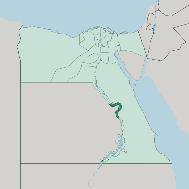
Towns & cities in Muḩāfaz̧at Qinā
Pick a town or city — each links to where to stay.
Base in Luxor. Most travellers sleep there and cross into Qena for the day, since the governorate's own beds cluster in Qena city, the provincial capital on the east bank, a short drive from the ferry across to Dendera. Nag Hammadi, downstream, is an industrial town built around its aluminium smelter.
Qus and Naqada are small farming towns strung along the river between Qena and Luxor. Choose Qena city if you want to wake beside the temple; choose Luxor, an hour south, for the fuller run of hotels.
About Muḩāfaz̧at Qinā
This is the elbow of the Nile.
What is Muḩāfaz̧at Qinā known for?
The river swings sharply east here before turning back, and Qena city sits on that bend, on the east bank. Directly across the water stands the temple of Dendera, one of the best-preserved sanctuaries in Egypt, its ceiling still carrying painted zodiac scenes under the sculpted face of Hathor. Sugar cane fills the floodplain, feeding the mills that make this one of Egypt's chief cane-growing regions.
The desert routes east to the Red Sea start from here too.
Where is Muḩāfaz̧at Qinā?
Muḩāfaz̧at Qinā occupies a stretch of the Nile valley in Upper Egypt, the southern part of the country. The river is everything here. It enters from the south near Luxor, curves hard to the east at Qena city, then bends back to the north, and that great loop gives the governorate its shape.
Nearly all its towns line the narrow band of green on either bank. Qena city stands on the east bank at the sharpest point of the bend, with the temple of Dendera on the west bank almost opposite. Downstream lie Nag Hammadi and Farshut; upstream toward Luxor sit Qus and Naqada.
Beyond the cultivated strip the land turns to desert fast. To the east the Eastern Desert climbs into dry hills cut by the Wadi Hammamat, the old caravan valley that carried traders and quarrymen from the river to the Red Sea coast. West of the Nile the desert runs flat and empty.
The whole governorate is essentially the river, its two green banks, and the rock beyond. Water and stone divide it, and everything people build clings to the seam between them.
What is Muḩāfaz̧at Qinā like?
Life here follows the cane and the river. The floodplain grows sugar cane in dense green blocks, and the harvest that feeds the local mills sets the rhythm of the working year across the governorate. Qena city has long been known for its potters, who throw the porous clay water jars, the qulla, that keep drinking water cool through the Upper Egyptian heat.
Faith runs in two channels side by side. This is deeply Muslim country, and it is also old Coptic ground: at Naqada, Christian families kept the Coptic tongue alive in daily speech far longer than most of Egypt did. Nag Hammadi carries a heavier weight of memory.
A farmer digging near the town in 1945 uncovered a jar of leather-bound codices, the Gnostic scriptures now known as the Nag Hammadi library, sealed away for some sixteen centuries. Egyptian Arabic is the everyday language. Music, moulids, and the saints' festivals draw crowds from the surrounding villages.
The temple of Dendera looms over all of it, its Hathor carvings a reminder that people have farmed and worshipped on this bend of the river for a very long time.
What is the history of Muḩāfaz̧at Qinā?
People settled this bend early. Naqada gave its name to the Naqada culture, the pre-dynastic society that took shape along these banks before the pharaohs and helped lay the ground for a unified Egypt. In the Greco-Roman age Qena city was Caene, the "new town," and Dendera's Hathor temple rose across the river in its present form.
Trade made the medieval town. Under the Fatimid and Mamluk rulers, caravans crossed the Wadi Hammamat between the Nile and the Red Sea ports, and Qus grew into one of Upper Egypt's great commercial centres on that route. The desert road east has shaped this place for three thousand years.
What is the climate of Muḩāfaz̧at Qinā?
Qinā is hot desert, through and through. Summers on the Nile bend are fierce and dry, with daytime heat that pushes people and work into the early morning and the evening. Rain almost never comes.
Winters turn mild and pleasant, cool after dark, and those months are the sensible time to walk Dendera or cross into the Eastern Desert toward the Red Sea. The porous clay water jars of Qena city exist for a reason. This is some of the hottest, driest country in Egypt.
How do you get to Muḩāfaz̧at Qinā?
The gateway is Luxor. Its airport, about an hour south, is where nearly every visitor lands, and the road and railway that follow the Nile carry you the rest of the way north to Qena city. Trains on the Cairo-to-Aswan line stop here, since the main valley railway runs straight through the governorate.
From Qena the Wadi Qena road strikes east across the Eastern Desert to the Red Sea coast at Safaga and Quseir, the modern heir to the old Wadi Hammamat caravan route. Most people come up from Luxor for the day.
Updated July 2026