Indonesia
Central Papua, Indonesia — Towns & Travel Guide


Central Papua is a province of Indonesia in the central highlands of New Guinea, holding Puncak Jaya, the island's highest peak.
About Central Papua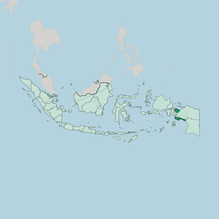
Towns & cities in Central Papua
Pick a town or city — each links to where to stay.
Nabire is the northern base, a lowland town on Cenderawasih Bay where boats leave for the whale sharks and the reefs of the national park. Timika anchors the south. It is the largest town in the province, the airport for the Grasberg mining district, and the staging point for climbs toward Puncak Jaya.
Liveaboards work the bay itself, sleeping divers over the coral for days at a stretch. Inland, around Lake Paniai, beds thin out fast. Choose Nabire for the sharks, Timika if you are heading up into the Sudirman Range.
About Central Papua
Two extremes define Central Papua.
What is Central Papua known for?
Puncak Jaya rises higher than any other summit in Indonesia and across Oceania, its shoulders in the Sudirman Range still holding the last equatorial glaciers found anywhere on the island of New Guinea. Below it lies the Grasberg mine, one of the largest gold and copper deposits on Earth, worked in the thin air above Timika. The other draw is water.
In Cenderawasih Bay, off the coast at Nabire, whale sharks gather beneath the fishermen's platforms all year.
Where is Central Papua?
Central Papua fills the middle of the island of New Guinea, on the Indonesian side of the border. The land climbs in three great steps. Along the north runs a coastal lowland on Cenderawasih Bay, the deep U-shaped gulf where Nabire, the provincial capital, sits.
From there the ground rises into the Sudirman Range, the western spine of the New Guinea Highlands, which carries Puncak Jaya and its shrinking Carstensz Glacier, the only ice left on the tropical island. High valleys hold the Paniai Lakes, Paniai, Tigi, and Tage, a chain of freshwater basins ringed by the villages of the interior. South of the divide the mountains break down into swamp.
The Mimika lowlands spread toward a mangrove coast on the Arafura Sea, drained by fast rivers off the highlands, and it is here that Timika has grown around the mining road. Eight regencies make up the province, from Nabire and Mimika on the two coasts to Puncak, Paniai, Dogiyai, Deiyai, Intan Jaya, and Puncak Jaya in the ranges between. Highland Papua lies to the east. The rest is mountain and forest, thinly tracked and often reached only by light aircraft.
What is Central Papua like?
The province is Melanesian to its core. Most people here are indigenous Papuans, split among dozens of highland and coastal groups who each keep their own language, with Indonesian used as the common tongue between them. The Mee, sometimes called Ekari, farm the cool basins around the Paniai Lakes, terracing sweet potato and raising pigs for the feasts that settle debts and marriages.
Higher up, near the glaciers, live the Amungme, whose ancestral land holds the Grasberg mine. Down on the southern mud the Kamoro carve, canoes, drums, and ancestor poles worked from a single trunk, a woodcarving tradition known across New Guinea. Christianity arrived with missionaries in the last century and shapes much of village life, though older beliefs about land and ancestors run beneath it.
Women knot the noken, the looped string bag carried from the forehead, a Papuan craft recognised by UNESCO. Markets in Nabire and Timika bring highlander and coast-dweller together over stalls of betel nut, taro, sago, and fish. The mine has drawn migrants from across Indonesia, so Timika is the mixed town.
The rest stays deeply local. Few roads join one valley to the next, and identity is still measured village by village.
What is the history of Central Papua?
Central Papua is one of Indonesia's youngest provinces, carved from the western regencies of Papua on 25 July 2022. Its deeper story is far older. The western half of New Guinea passed from Dutch control to Indonesia in the 1960s, and this rugged interior was among the last places outsiders reached, missionaries only opened the Mee country around the Paniai Lakes in the mid-twentieth century.
Everything shifted when copper was found under the Amungme highlands. The Grasberg mine, begun in the 1970s above Timika, turned a remote district into the economic engine of the province.
What is the climate of Central Papua?
Central Papua stacks every tropical climate on top of itself. The two coasts are hot and wet, and the southern lowlands around Timika count among the rainiest ground in Indonesia, soaked by rain that pours off the mountains almost daily. Climb the Sudirman Range and the air cools fast.
Frost bites the high valleys at night, and Puncak Jaya keeps a cap of glacier ice, a rarity this close to the equator. There is no real dry season. Only wetter, and less wet.
How do you get to Central Papua?
Central Papua is reached by air. No road links the province to the rest of Indonesia, so nearly every arrival lands at Mozes Kilangin airport in Timika or the smaller field at Nabire, on flights up from Jayapura, Makassar, and other Indonesian hubs. From those two airports, light aircraft fan out to the interior, the only way into highland towns like Enarotali on the shore of Lake Paniai.
Pelni ferries also call at the coastal ports. Overland travel between valleys barely exists.
Good for
Updated July 2026