Indonesia
Highland Papua, Indonesia — Towns & Travel Guide


Highland Papua is Indonesia's only landlocked province, high in the Baliem Valley among the peaks of New Guinea.
About Highland Papua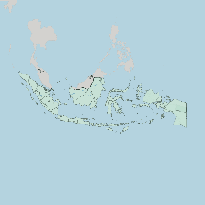
Towns & cities in Highland Papua
Pick a town or city — each links to where to stay.
Wamena is the base for almost everyone. The town sits on the floor of the Baliem Valley, and its guesthouses and the Baliem Pilamo Hotel hold most of the province's beds. Trekkers use it as a start and end point, walking out through Kurima and up to ridge villages such as Kilise, sleeping in a Dani honai or a tent along the way.
Book Wamena if you want a room with walls and power. Choose the village homestays if you would rather wake among the gardens and pig fences of the valley.
About Highland Papua
What is Highland Papua known for?
Highland Papua is the interior of Indonesian New Guinea, a province with no coastline at all. The Baliem Valley is its centre, a broad tableland where the Dani grow sweet potato in ditched gardens and keep pigs as wealth and for feasts. Wamena, the valley town, is the one place with an airstrip big enough for jets.
Puncak Mandala and Puncak Trikora rise along the eastern ranges, the two tallest summits in the province. Traders fly everything in.
Where is Highland Papua?
Highland Papua fills the mountain spine of western New Guinea. It is the only province of Indonesia without a coast. Papua New Guinea runs along its eastern edge, the residual province of Papua wraps the north, Central Papua holds the west, and South Papua falls away to the south. Ridges do the bordering here.
The Jayawijaya Mountains run down the middle, part of the central cordillera that both halves of New Guinea share. Above the town of Wamena, that spine climbs past four thousand metres. The Baliem Valley opens in the centre, a flat green trench roughly seventy kilometres long, walled by steep grass slopes.
The Baliem River threads that floor before cutting south through deep gorges toward the lowlands of Yahukimo. Smaller basins repeat the pattern, among them the Toli Valley over in Tolikara. Puncak Mandala stands near the Papua New Guinea border in the Star Mountains, and Puncak Trikora rises to the west in the Maoke ranges, the two highest points the province holds.
Both once wore ice. Their caps melted through the last century, yet the high valleys still sit cold enough for frost to whiten the gardens on the sharpest nights.
What is Highland Papua like?
Three peoples share the valleys: the Dani in the middle, the Lani to the west, and the Yali in the steep country to the east. Their staple is the sweet potato, grown in gardens ditched against the cold and cooked over stones with pork at a pig feast. Families live in the honai, a round hut with a thatched cone for a roof and a fire inside.
Warmth matters up here. Older men still wear the koteka, and at Jiwika the Dani keep the blackened, smoke-cured mummy of a war chief. Grief here has left marks on the body.
Older Dani women bear fingers shortened in mourning, an act once made to honour a dead relative. The outside world only reached these valleys in 1938, when Richard Archbold flew over a farmed and populated highland no map had recorded. Missionaries followed, and churches now stand among the honai.
Old and new coexist. Dozens of Papuan languages divide the ranges, valley by valley. Each August the Baliem Valley draws the tribes together for a festival of mock battle, pig races, and dance.
What is the history of Highland Papua?
People farmed these valleys for thousands of years before any outsider knew they were there. The Dani were already terracing sweet-potato gardens on the Baliem floor when an American expedition first sighted the valley from the air in 1938. Control passed from the Dutch to Indonesia in 1963, and the whole highland was governed for decades as part of the sprawling province of Papua.
That changed in 2022. Indonesia split Papua into smaller provinces, and the mountains became Papua Pegunungan, the country's only landlocked province.
What is the climate of Highland Papua?
Height, more than season, rules the climate of these mountains. The Baliem Valley sits high enough that Wamena stays mild through the year, warm by day and cold enough after dark to want a fire in the honai. Days stay warm, nights cold.
Rain falls in every month, heaviest when cloud piles against the ranges in the afternoon. The land lies close to the equator, so day length and temperature barely shift from one month to the next. Up on the high shoulders below Puncak Trikora, frost still forms on the coldest nights.
How do you get to Highland Papua?
You reach Highland Papua by air. No road climbs the ranges from the coast, so the flight from Jayapura is the way in for nearly every visitor. Wamena Airport, on the Baliem Valley floor, is the one strip in the highlands long enough for a jet, and turboprops fan out from it to smaller towns like Oksibil and Dekai.
Everything the province cannot grow arrives the same way, from fuel to rice to sheets of roofing iron. Weather closes the runways often. Cloud over the passes can hold a plane on the ground for a day.
Good for
Updated July 2026