Indonesia
Provinsi Sulawesi Barat, Indonesia — Towns & Travel Guide


West Sulawesi is a young Indonesian province on the Makassar Strait, its coast the seafaring homeland of the Mandar people.
About Provinsi Sulawesi Barat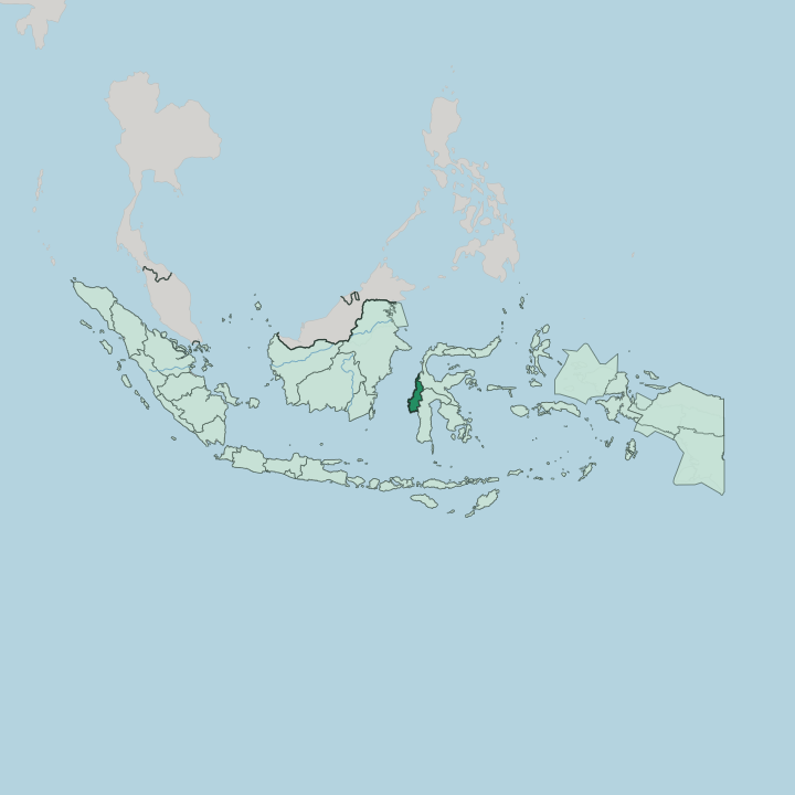
Towns & cities in Provinsi Sulawesi Barat
Pick a town or city — each links to where to stay.
Mamuju works as the practical base, the provincial capital and the coastal town with the widest choice of beds, and the natural place to sort out onward transport. Majene lies down the shore. That old Mandar port suits travellers drawn to the sea and its shipbuilding heritage.
For the highlands, most people push up through Polewali Mandar to Mamasa, sleeping in the cool valley among its wooden houses. Guesthouses grow sparse past these towns, so plan the mountain leg around daylight.
About Provinsi Sulawesi Barat
Two worlds meet within one province.
What is Provinsi Sulawesi Barat known for?
Along the Makassar Strait, the Mandar people built a seafaring culture whose fastest sailboat, the Sandeq, still races the strait each dry season on outriggers of light timber. Inland, the road climbs from the cocoa farms around Polewali Mandar to the cool highland valleys of Mamasa, where wooden houses recall those of neighbouring Toraja. Mamuju anchors the coast as the provincial capital.
Most travellers come for the boats, the mountains, or both.
Where is Provinsi Sulawesi Barat?
West Sulawesi runs as a long band down the western flank of Sulawesi, facing the Makassar Strait. That strait is wide water. It divides the island from Borneo and carries the shipping that has always tied this coast to the rest of the archipelago.
The province is mostly upright country: a thin ribbon of lowland hugs the shore, and behind it the land rises quickly into steep, forested mountains that run the length of the interior. To the east the ranges climb toward the borders with South Sulawesi and Central Sulawesi. Mount Gandang Dewata rises highest of these summits, its slopes folded into the Gandang Dewata National Park that guards the province's core.
Rivers drain the highlands westward to the strait. The Karama is the longest, cutting across the northern third of the province and reaching the sea through the Kalumpang valley, where Neolithic sites mark some of the oldest settlement on the island. Further south the Lariang gathers its headwaters near the Central Sulawesi border before winding away.
Off the coast lie the Balabalagan Islands, a scatter of low coral atolls set far out in the Makassar Strait. Six regencies divide the province between the coast and the hills. The land does the sorting here.
What is Provinsi Sulawesi Barat like?
The coast belongs to the Mandar. They are a people of the sea, and their name attaches to a language, a cuisine, and the confederation of small kingdoms that once ran this shore. Their emblem is the Sandeq.
This slender outrigger sailboat, cut for speed, still carries fishermen across the Makassar Strait under a single triangular sail, and each dry season the boats gather for the Sandeq Race up the coast. Islam sets the rhythm of coastal life. Majene keeps the Mandar museum, and its boatyards still shape hulls the old way.
The mountains tell another story. In the highland valleys around Mamasa, the culture bends toward Toraja rather than the sea, and many people here are Christian rather than Muslim. Timber houses stand on posts with broad saddle roofs, their gables carved and painted.
Around Minanga, the dead were once laid in tedong-tedong, coffins hollowed from single logs and left among the rocks. Weavers work backstrap looms in the hamlets. The Kalumpang people hold the upper Karama, with traditions older than either kingdom on the coast.
Two cultures share one province.
What is the history of Provinsi Sulawesi Barat?
Long before any province, the Mandar coast was governed by two old confederations: seven kingdoms of the river mouths and seven of the highlands, bound by a shared code. Balanipa led the coastal seven. Dutch power reached the shore in the wake of the treaty signed at Bungaya in 1667, and colonial rule followed.
Older still is the Karama valley, where the Kalumpang sites record farming and pottery from deep antiquity. The modern province is new, split from South Sulawesi only in 2004.
What is the climate of Provinsi Sulawesi Barat?
Heat and rain define the lowlands. The coast along the Makassar Strait stays hot and sticky through the year, with heavy downpours that swell the Karama and the other rivers draining the ranges. There is no cold season on the shore, only wetter and drier spells as the monsoon turns.
The Mamasa highlands break the pattern. Up in those valleys the air runs cool, sometimes sharp at night, which is why the hill country feels a world apart from the beaches below.
How do you get to Provinsi Sulawesi Barat?
Reaching West Sulawesi means going through Makassar first. From Sultan Hasanuddin airport there, a short flight crosses to Tampa Padang, the airstrip serving Mamuju. The alternative is the coast road.
The Trans-Sulawesi highway threads north from Makassar through Majene to the capital, a long haul of many hours by bus or car along the strait. Mamasa is harder again, up a slow, twisting climb from Polewali Mandar into the mountains.
Good for
Updated July 2026