Indonesia
South Papua, Indonesia — Towns & Travel Guide


South Papua is one of Indonesia's newest provinces, a wilderness of swamp forest, wet savanna and huge rivers along the Arafura coast of New Guinea.
About South Papua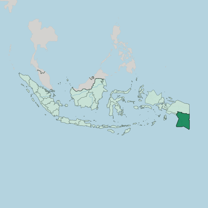
Towns & cities in South Papua
Pick a town or city — each links to where to stay.
Rooms turn up in only a few river and coast towns. Merauke is the obvious base, the one place with a real airport and hotels, set on the Maro River beside the Wasur savanna. Agats, the Asmat capital, is stranger and finer: a town built entirely on stilts and boardwalks above tidal mud, reached only by boat or small plane.
Tanah Merah sits far up the Digul River, the old colonial exile town of Boven-Digoel. Kepi opens the Mappi lowlands toward Korowai country. Pick the town that matches the trip.
About South Papua
What is South Papua known for?
Two things put South Papua on the map: Asmat woodcarving and raw wilderness. The Asmat carve ancestor poles and war shields prized by collectors far beyond Agats, and that craft anchors the province's fame. Wasur National Park spreads a wet savanna full of agile wallabies, cassowaries and crocodiles across the flats behind Merauke, the easternmost town in the country.
Deep inland, the Korowai are known for building houses high in the trees. It stays wild.
Where is South Papua?
South Papua fills the far south-east of the Indonesian half of New Guinea, the great island Indonesia shares with Papua New Guinea. It is the least crowded province in the country. Central Papua and Highland Papua lie to the north, where the land climbs toward the central range; Papua New Guinea runs along the eastern border; and the Arafura Sea washes the whole southern coast, facing Australia across the water. Merauke, the easternmost town in the country, sits near that south-eastern corner where the coast turns toward the frontier.
Almost all of it is flat. This is one enormous lowland. Rivers born in the northern highlands wander south across it in wide brown loops, the Digul, longest of them, together with the Maro that passes Merauke and a dozen more.
Between the rivers lie swamp forest and lowland rainforest, some of the least-disturbed wetland left in the country, and near the Arafura shore the trees give way to the wet savanna of Wasur National Park. The ground barely rises. In the rainy months much of the interior floods and the rivers become the only roads.
Solid land can be hard to find. Crocodiles work the tidal reaches near the coast.
What is South Papua like?
South Papua belongs to Anim Ha, the lowland cultural world of southern New Guinea, and it feels nothing like the highlands to the north. Dozens of peoples share these swamps and rivers. The Marind around Merauke are known for elaborate ceremonial body-paint and feather dress, drawn from a dense mythology of totemic ancestors.
In the tidal forests to the north-west the Asmat carve the bisj poles that carry the dead, some of the most sought-after art in the Pacific. Deep in the eastern interior toward the Digul the Korowai raise their houses into the treetops. Indonesian ties it together, but each people keeps its own tongue, and the province counts dozens of them.
Life runs on sago and the river. The staple is sago flour, beaten from the palm and baked, eaten with fish, wild boar, deer and the agile wallabies of the savanna. Villages string along the water, and dugout canoes still do the work that roads do elsewhere.
The outside world came late here. Merauke grew from a Dutch colonial post planted on the coast to hold the far edge of the East Indies, and mission stations followed the rivers inland only in the twentieth century. Old ways run close to the surface.
What is the history of South Papua?
People have worked these swamps and rivers for thousands of years, but the borders came late. The Dutch founded Merauke in 1902 as the south-eastern outpost of their New Guinea colony, partly to check headhunting raids crossing the modern border with Papua New Guinea. In 1927 they cut Boven-Digoel out of the upriver forest as an internment camp, exiling Indonesian nationalists into the Digul swamps.
Indonesia took the territory in 1963. The four southern regencies were carved off as their own province only in 2022. Three more Papuan provinces split off the same year.
What is the climate of South Papua?
South Papua runs hot and wet all year, but it splits cleanly into two seasons. From about December to May the north-west monsoon drives the rains, and the lowland floods; from June to November dry south-easterly winds blow up off the Arafura Sea and Australia, and the water pulls back. That dry spell is unusual for New Guinea.
It lets the Wasur wetlands harden into open savanna, when wallabies and deer crowd the shrinking waterholes. Temperatures barely move from warm. The heaviest rain falls inland toward the highlands, where some of the wettest country in Indonesia drains south through the swamps.
How do you get to South Papua?
Flying is the only practical way in. Mopah Airport at Merauke handles the province's air link, with connections up the coast to Jayapura and on to the rest of Indonesia through hubs like Makassar. No highway reaches South Papua from the west; the swamps and the sheer distance see to that.
Once the plane lands, travel gets slower still. Agats and the Asmat villages have no roads at all, reached only by longboat or light aircraft, and much of the interior moves by river. The border with Papua New Guinea is the one land crossing.
Updated July 2026