Iraq
Maysan Governorate, Iraq — Towns & Travel Guide


Maysan is a wetland province of south-eastern Iraq, where the Tigris fans into marshes along the Iranian border and Amarah anchors the plain.
About Maysan Governorate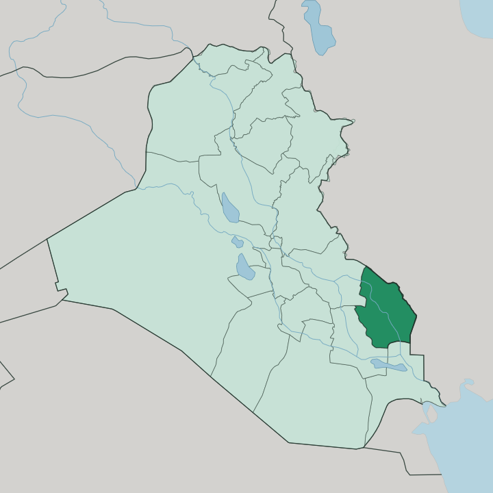
Towns & cities in Maysan Governorate
Pick a town or city — each links to where to stay.
Amarah is the only real base. The capital stands on the Tigris astride Highway 6, and its handful of hotels serve the grain and silver trade of the plain; you stay here and travel out. The Hawizeh Marshes have no lodging of their own, and reaching the reed beds and their water buffalo means a boat from a marsh village.
Ali al-Gharbi, the northern Tigris town on the road down from Kut, is a waypoint more than a destination. Choose Amarah for the river and the crafts; treat the marshes as a day out.
About Maysan Governorate
Maysan is marsh country.
What is Maysan Governorate known for?
Its southern reaches dissolve into the Hawizeh Marshes, part of the Ahwar wetlands that carry a UNESCO World Heritage listing, and the last of Iraq's Marsh Arabs still pole reed boats and herd water buffalo through the reed beds there. Amarah, the provincial capital, sits on the Tigris and trades the grain, dates, and livestock of the surrounding plain, and its silversmiths and weavers gave the town an old reputation for craft. The Halfaya oil field, one of Iraq's largest, pumps just west of the reeds.
Where is Maysan Governorate?
Maysan lies in the far south-east of Iraq, its eastern edge running along the Iranian frontier and its southern rim opening toward Basra. Maysan lies flat across the Mesopotamian plain. It belongs to the lower Mesopotamian plain, and the Tigris is the thread that ties it together, entering from the north-west near Ali al-Gharbi, passing Amarah, and splitting into distributary channels that lose themselves in the wetlands.
Two of those Tigris branches, the Musharrah and the Kahla, feed the Hawizeh Marshes, which straddle the border and take further water from the Karkheh flowing out of Iran. In the south the ground stops being solid at all. Reed beds, open lagoons, and shifting islands of matted vegetation make up the Ahwar, the Mesopotamian Marshes that once spread across the whole southern province.
Amarah stands on a low ridge above the Tigris, the one firm town in a province of water and silt. West of the river the plain dries toward semi-desert. The province covers roughly sixteen thousand square kilometres, most of it low, cultivated near the channels and given over to reeds and buffalo pasture wherever the water pools.
Its geography is written in water more than in rock.
What is Maysan Governorate like?
Maysan's culture grew out of the reeds. For generations the Marsh Arabs, the Madan, lived in houses woven wholly from marsh reeds, raised water buffalo on floating platforms, and moved between islands by narrow canoe, and that amphibious life gave the province an identity unlike the dry towns upriver. Fishing, reed-cutting, and buffalo herding still shape the rhythm of the wetland villages.
The draining of the marshes in the early 1990s scattered most of that population and only a fraction returned when the water came back, so the old way of life now survives in patches rather than across the whole south. The population is overwhelmingly Shia Arab, and Maysan is known within Iraq for a fierce independence of temper. Amarah adds an urban layer to the reed culture.
Its silversmiths worked a distinctive niello and its weavers made cloth that carried the town's name to the wider market, crafts tied to the trade that the Tigris port sustained. Older still are the Mandaeans, a small ancient community whose river baptisms need the running water the province has always had. The result is a province defined by water, reed, and river, more than by any monument.
What is the history of Maysan Governorate?
Maysan carries an ancient name. It comes from Mesene, the Aramaic name for Characene, the small kingdom that Hyspaosines carved out of the collapsing Seleucid state and ruled from Charax Spasinu, the port Alexander the Great had founded near the head of the Gulf. That river-and-marsh kingdom traded for three centuries before the Sasanians absorbed it, and the name Maysan clung to the land ever after.
The modern town of Amarah is far younger, laid out in the 1860s as an Ottoman garrison on the Tigris. The province was called Amara until 1976, when it took back the older name.
What is the climate of Maysan Governorate?
Maysan runs hot and dry. Amarah has a hot desert climate, with summers that push the plain into fierce, cloudless heat and winters that stay mild and bring the year's modest rain. The marshes soften the extremes only in their own reed-lined pockets.
Away from the water the province bakes, and dust carried off the drying wetlands can thicken the air. The best time to travel the Tigris and the reed beds is the cooler stretch from late autumn into early spring, when the heat eases and the birds that winter in the Ahwar arrive in numbers.
How do you get to Maysan Governorate?
Most travellers reach Maysan overland. Highway 6 is the spine, running down from Baghdad through Kut and into Amarah before carrying on south to Basra, and it takes the bulk of the province's traffic. The rail line between Baghdad and Basra crosses the same plain.
There is no busy passenger airport in the province itself, so those flying in usually land at Basra to the south and drive up the Tigris road to Amarah. From the capital the marshes are reached by road to a marsh village and then by boat.
Good for
Updated July 2026