Iraq
Wasit Governorate, Iraq — Towns & Travel Guide


Wasit is the governorate east of Baghdad where the Tigris bends past Kut toward the Iranian frontier.
About Wasit Governorate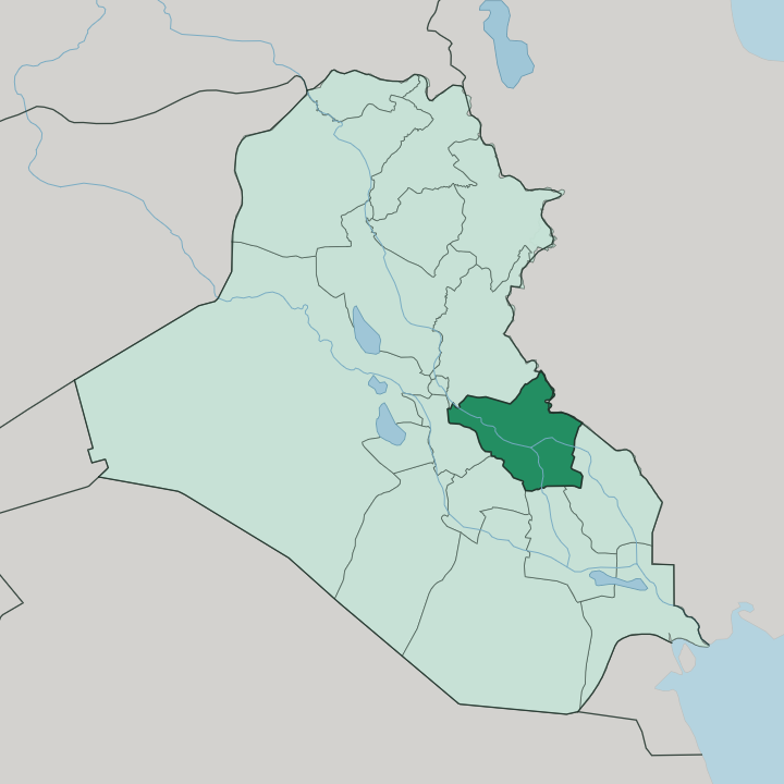
Towns & cities in Wasit Governorate
Pick a town or city — each links to where to stay.
Al-Kut is the practical base. It holds the governorate's river port, its markets and nearly all of its beds, folded into that sharp loop of the Tigris. Al-Suwaira sits far to the north, on the west bank close to Baghdad, ringed by fruit groves and palm orchards.
Badra lies out east toward the Iranian border and the Zurbatiyah crossing. Stay in Al-Kut for the river town and the plain around it; head to Al-Suwaira if you want the orchards near the capital, or Badra if the border is where you are bound.
About Wasit Governorate
What is Wasit Governorate known for?
Wasit takes its name from an Arabic word for "middle", because the medieval city of Wasit sat midway along the Tigris between Baghdad and Basra. That old city is gone. Its ruins lie southeast of Kut, abandoned once the river shifted its course and left the harbour dry.
The living centre now is Al-Kut, wrapped inside a tight U-bend of the Tigris on the river's left bank. Farmland spreads out from there across the plain, and the eastern edge of the governorate runs up against the Iranian border at Zurbatiyah.
Where is Wasit Governorate?
Wasit lies in eastern Iraq, southeast of Baghdad, a lowland province stretched along the middle Tigris. The river is the spine of it. It enters from the northwest near Al-Suwaira, curves down through Al-Aziziyah and Al-Nu'maniya, and swings hard around Al-Kut in the loop that almost makes the old town an island.
At Kut the Shatt al-Gharraf branches south off the Tigris, carrying water toward the Euphrates and the marshes below Nasiriyah. Most of the governorate is flat alluvial plain, the silt the river has laid down over centuries, worked into fields of wheat, barley and rice. The far east is different.
There the plain rises toward low hills along the frontier with Iran, and the border town of Badra sits below them near the Zurbatiyah crossing. Between the cultivated land and the drier ground lie seasonal wetlands. Wasit holds the marshes of Shuwayja, Al-Attariyah and Hor Aldelmj, shallow reed-beds that flood and shrink with the water the Tigris allows them.
Basra lies far downstream to the south. Baghdad is the neighbour to the northwest, and the road between the capital and Kut is the artery that ties the province to the rest of the country.
What is Wasit Governorate like?
Life in Wasit is bound to the river and the land it waters. The population is mostly Shia Arab, with Marsh Arab communities in the wetland districts who have long lived by the reed-beds and buffalo herds of Shuwayja and Hor Aldelmj. Arabic is the everyday language.
The rhythm of the place is agricultural, set by the seasons of wheat, barley and rice on the Tigris plain and by the palm and fruit orchards around Al-Suwaira. History sits close to the surface here. The buried city of Wasit, once the seat of the Umayyad governor of Iraq, still marks the province with the ruins of its great mosque and the tells scattered across the land around it.
Near Badra, out toward the Iranian border, lie the remains of Der, an old city-state of the Mesopotamian world. Kut carries a memory of its own. In the reeds and the mudbrick, in the market on the riverbank and the shrine on the plain, Wasit reads as a working corner of southern Iraq rather than a showpiece.
That is the appeal.
What is the history of Wasit Governorate?
The province is named for a city that no longer stands. Around 702 the Umayyad governor al-Hajjaj ibn Yusuf built Wasit on the Tigris as a garrison and seat of power, midway between Kufa and Basra. It thrived, then died.
The river moved and left it stranded, and Kut inherited the region's centre along with a hard chapter of its own. In the winter of 1915 a British Indian force fell back into the U-bend at Kut, where the Ottoman army surrounded and trapped it. The Siege of Kut ran 147 days and ended in April 1916 with one of the worst British surrenders of the First World War.
What is the climate of Wasit Governorate?
Wasit is hot and dry. Summers on the Tigris plain are long and fierce, with July afternoons that push well past 40 degrees and often touch 50 in the shade. Rain barely falls between spring and autumn, so the marshes of Shuwayja and Al-Attariyah shrink back to cracked mud while the fields lean entirely on river water.
Winters are short and mild, the season when the plain turns green and the crops come in. The land east toward the Iranian hills stays drier still.
How do you get to Wasit Governorate?
Almost everyone comes overland from Baghdad. The capital's airport is the nearest gateway, and from there the highway runs southeast to Al-Kut in roughly two to three hours across the flat Tigris plain. Wasit has no commercial airport of its own.
Shared taxis and private cars do the work between Kut and the towns around it. On the eastern side the province meets Iran at the Zurbatiyah crossing near Badra, a busy land border that ties Wasit to the Iranian city of Mehran and the roads beyond.
Good for
Updated July 2026