Iraq
Muḩāfaz̧at Dhī Qār, Iraq — Towns & Travel Guide


Dhī Qār is the Sumerian heartland of southern Iraq, where the ruins of Ur and the Mesopotamian Marshes meet the lower Euphrates.
About Muḩāfaz̧at Dhī Qār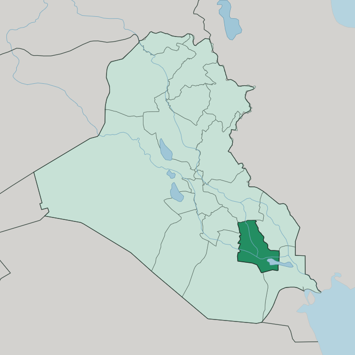
Towns & cities in Muḩāfaz̧at Dhī Qār
Pick a town or city — each links to where to stay.
Nasiriyah is the only practical base, and nearly every trip in the province runs out from it. Two draws pull in opposite directions. The city sits on the lower Euphrates, and the ziggurat of Ur stands a short drive south-west across the dry plain.
The marshes lie the other way, toward Al-Chibayish in the south, where the reeds and open water begin. Beds thin out fast down there. Choose Nasiriyah for the archaeology; push down to the Al-Chibayish edge when the marshes and their reed boats are what you came for.
About Muḩāfaz̧at Dhī Qār
What is Muḩāfaz̧at Dhī Qār known for?
This is Sumer's cradle. Dhī Qār holds the ruins of Ur, whose partly restored Great Ziggurat still rises from the plain, along with Eridu, Lagash, Larsa, Girsu and Umma, cities that helped invent writing and the city itself. Its southern third dissolves into the Mesopotamian Marshes, the reed-and-water world of the Ma'dan, or Marsh Arabs, who pole slender boats between floating islands.
Nasiriyah, the provincial capital, sits on the lower Euphrates and serves as the base from which travellers reach both. Water and mud brick define the whole province.
Where is Muḩāfaz̧at Dhī Qār?
Dhī Qār lies in southern Iraq, on the flat alluvial plain that the Tigris and Euphrates have built up over thousands of years. The lower Euphrates is its spine. The river slides past Nasiriyah, the capital, before spreading southward into standing water.
That water is the Mesopotamian Marshes, the great reed wetland that swallows the southern third of the province and reaches on toward Basra beyond it. Al-Qādisiyyah and Al Muthanna sit to the north and west, Maysan to the east, and Basra to the south-east, so Dhī Qār occupies the low ground where the plain gives way to marsh. Away from the river and the reeds, the land is dry.
Desert and semi-desert stretch across the parts the water never reaches, baked hard for much of the year. The old Sumerian cities were built along channels that have since shifted or dried, which is why ruins like Ur now stand out on open ground rather than beside a living river. Nasiriyah anchors the settled belt, strung along the Euphrates roughly midway between Baghdad and the head of the Gulf.
Everything here is shaped by where the water is, and where it no longer runs.
What is Muḩāfaz̧at Dhī Qār like?
Dhī Qār carries two cultures at once, and both grow straight out of the land. The first is the deep memory of Sumer, whose cities here first pressed writing into clay and raised temple platforms like the ziggurat at Ur. That inheritance is a source of real local pride.
The second is the living world of the marshes, home to the Ma'dan, the Marsh Arabs, whose reed houses, water buffalo and canoe-borne life have persisted in the wetlands for millennia. Arabic is the everyday language, and the population is overwhelmingly Shia, which threads the province into the wider devotional map of southern Iraq and its pilgrim routes to Najaf and Karbala. Reed architecture is a craft in itself.
The mudhif, a great arched guest hall woven entirely from marsh reeds without a single nail, is built the way it has been built since Sumerian times, and its shape appears on cylinder seals four thousand years old. Poetry, tribal hospitality and the buffalo herds tie the marsh communities together. Nasiriyah, for its part, is the province's cultural anchor, with a museum whose Sumerian, Babylonian and later holdings gather the region's long story under one roof.
Old and new sit close here. The reed boat and the mud-brick tell belong to the same province, and both are still very much alive.
What is the history of Muḩāfaz̧at Dhī Qār?
The history here is almost impossibly long. Dhī Qār was the core of Sumer, where Ur, Eridu, Lagash and Larsa flourished more than four thousand years ago and gave the world some of its earliest writing, law and cities. Ur itself was a royal capital, and its Great Ziggurat was raised in the twenty-first century BCE.
The modern capital is far younger: Nasiriyah was founded in 1872 by Nāṣir al-Saʿdūn Pasha, a sheikh of the Muntafiq tribal confederation, and named for him. The province was called Muntafiq Governorate after that same confederation until 1976, when it was renamed Dhī Qār. Ancient and recent history layer directly on top of each other.
What is the climate of Muḩāfaz̧at Dhī Qār?
Dhī Qār runs hot and dry. Summers on the plain are punishing, with cloudless months from June into September pushing well past 45 degrees Celsius, and the desert beyond the Euphrates offers no shade. Rain is scarce and falls mostly in the mild winter, when nights on the marshes can turn genuinely cold.
The wetlands soften the heat only close to the water. Everywhere else, the sun rules the calendar.
How do you get to Muḩāfaz̧at Dhī Qār?
Most travellers reach Dhī Qār overland from Baghdad. Nasiriyah lies on the lower Euphrates roughly 360 km south-southeast of the capital, a long road run down Highway 8 through the open plain. There is an airport at Tallil, south-west of the city near Ur, but scheduled civilian flights have been sporadic.
Many people fly into Baghdad or Basra instead and drive the rest. From Nasiriyah, local roads fan out west to Ur on the dry plain and south to Al-Chibayish at the edge of the marshes. The road does the work here.
Updated July 2026